
Wild Weather leads to travel advisory: Heavy rain, heat, flash flooding and tornado warning issued
Bad weather is rolling in like Elvira Gulch before the tornado that blew Dorothy out of Kansas.

GRAY, MAINE – Bad weather is rolling in like Elvira Gulch before the tornado that blew Dorothy out of Kansas.
Right now it’s not just the heat or the humidity, both of which are oppressive – although there is a severe heat warning in effect. But the National Weather Service in Gray, Maine, has also issued a flash flood warning for Sullivan County in central New Hampshire, Southern Grafton County in northern New Hampshire, Northern Cheshire County in southern New Hampshire, Northwestern Hillsborough County in southern New Hampshire, Northwestern Merrimack County in central New Hampshire until 7:30 p.m.
The Service also issued a Code Red severe thunderstorm alert for Manchester, in effect between 5:30 and 6:30 p.m.
Closer to home, Manchester Police issued a Nixle alert at 5:30 p.m. asking residents to refrain from driving on all city streets, and the National Weather Service added a flash flood warning for Greater Manchester, effective through 8:30 p.m.
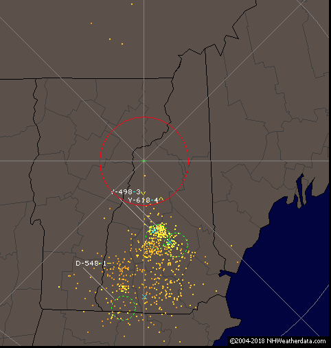
As of 3:24 p.m. Doppler radar indicated thunderstorms producing heavy rain across the warned area, and a brief tornado warning was issued for parts of Merrimack and Sullivan counties.
Flash flooding is ex
pected to follow the heavy rains. Some locations that will experience flooding include Keene, Claremont, Franklin, Henniker, New London, Grafton, Charlestown, Antrim, Hancock, Bradford, Danbury, Harrisville, Nelson, Newport, Gilsum, Windsor, Walpole, Warner, Hillsborough and Alstead. This includes Interstate 89 between mile markers 17 and 42. This also includes Mount Kearsage and Mount Sunapee.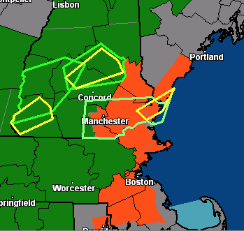
Be prepared to turn around if you encounter flooding. Most flood deaths occur in vehicles, according to the National Weather Service.
NHweatherdata.com shows a flurry of lightning activity on the New Hampshire map, and as of 4:30 p.m. there were lightning strikes happening every three minutes or so. The extreme heat warning also shows on the map as bright orange, and includes the Greater Manchester area.


