
What is the New Hampshire Zoning Atlas?
RELATED STORY⇒ NH Zoning Atlas may be turning point in housing crisis The New Hampshire Zoning Atlas project researched, catalogued, digitized and graphically displays all of New Hampshire’s housing-related zoning regulations, community-by-community, district-by-district. It is a policy-neutral too


RELATED STORY⇒ NH Zoning Atlas may be turning point in housing crisis
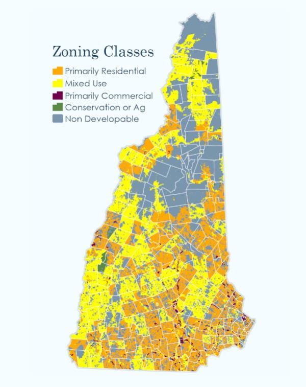
The New Hampshire Zoning Atlas project researched, catalogued, digitized and graphically displays all of New Hampshire’s housing-related zoning regulations, community-by-community, district-by-district.
It is a policy-neutral tool for analysis, available free to the public and part of the National Zoning Atlas project, headed by Sara Bronin, at Cornell University. It’s the third completed zoning atlas in the U.S., after Connecticut and Montana. Bronin said there are two dozen states creating atlases.
The NHZA leadership team includes Max Latona, executive director, Center for Ethics in Society at St. Anselm College; Jason Sorens, senior research faculty, American Institute for Economic Research; Ben Frost, chief legal officer, N.H. Housing; Noah Hodgetts, principal planner, N.H. Office of Planning and
Development; Rick Lederer-Barnes, GIS specialist and environmental planner, Upstate GIS; Sarah Marchant, chief of staff and vice president, ROC-NH, Community Loan Fund.
College interns who worked on the project, all New Hampshire residents, are Jacob Akey, Thomas Donovan, Carolyn Hill and Donald Jepsen, all St. Anselm students; Eli Cronin, Mary Baldwin University; Alyssa Papantonakis, Gettysburg College; Sam Latona, Cornell University; Isabel Blume, Colgate University.
The project took 16 months and involved collecting and synthesizing zoning codes from across the state to create a single spreadsheet cataloging every zoning district. The spreadsheet contains basic information such as the name and abbreviation for each district, whether the district is an overlay, and the primary purpose of the district (residential, mixed use, or non-residential). Mulltiple characteristics were also coded into the spreadsheet regarding treatment of different housing types, dimensional requirements, parking requirements, affordable or elderly housing requirements, and other considerations.
Geographic information systems (GIS) data was collected for each jurisdiction, where available. The GIS files, along with dozens newly created for the project by digitizing print versions of zoning maps, were merged into a single statewide GIS feature layer. That layer was joined with a modified version of the zoning attribute table. Areas considered to be non-developable because of permanent protection status or the presence of 10 or more contiguous acres of water and/or wetlands were clipped out of the statewide zoning layer. The resulting layer allows for the visualization and analysis of the “buildable” areas , which is approximately 61% of the state.
There are two datasets:
1) A Google spreadsheet with the raw data found in local ordinances, including textual descriptions of complex rules that could not be summarized with a single number without some loss of information, and covers all zoning districts in the state. including unmapped districts.
2) A data set available in comma-separated values (csv) format, covers only mapped districts, includes state legal provisions that in some cases override local zoning rules inconsistent with state law, and interprets complex rules as numerical codes suitable for statistical analysis and filtering operations in the map. It also removes base districts that are wholly contained within overlay districts to avoid double-counting. The second dataset links up to the attribute table in the ArcGIS feature class for the state.
– Information from New Hampshire Zoning Atlas


