
Weekend weather: Windy Valentine’s day, then snow + snow = lots of snow
Valentine’s Day Forecast: Expect a mostly sunny day, but be prepared for strong winds with gusts over 40 mph. The high temperature will be 29 degrees, but it will feel like just 14 due to the wind chill. Winds will be coming from the northwest at 15-25 mph. Dress warmly and hold onto your hats!


Rick Gordon’s Weather Watch
Follow our YouTube channel here.
Today’s weather
Valentine’s Day Forecast: Expect a mostly sunny day, but be prepared for strong winds with gusts over 40 mph. The high temperature will be 29 degrees, but it will feel like just 14 due to the wind chill. Winds will be coming from the northwest at 15-25 mph. Dress warmly and hold onto your hats!
5-Day Outlook
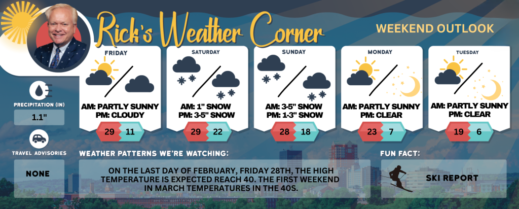
Valentines Day: Mostly sunny, windy (gusts over 40 mph), & colder. High 29 (feel like 14) Winds: WNW 20-30+ mph
Friday night: Clear to partly cloudy & cold. Low 11 Winds: WNW 5-15 mph
Saturday: Cloudy with snow showers developing in the afternoon. High 29 Winds: Light & Variable
Saturday night: Watching a potential winter storm. Periods of snow (3-5″) Low 22 (feel like 17) Winds: ENE 5-15 mph
Sunday: Watching a potential winter storm. Snow & an icy mix during the morning (3-5″) turning to freezing rain & sleet. High 28 (fee like 15) Winds: NE 10-20 mph
Sunday night: Snow (1-3″). Low 18 (feel like 5) Winds: NW 10-15+ mph
Presidents Day: Frigid gusty wind that could gust over 40 mph with clouds & sun. High 23 (feel like 7) Winds: WNW 20-30+ mph
Monday night: Becoming clear, windy, and frigid. Low 7 (feel like -8) Winds: WNW 15-25+ mph
Tuesday: Mostly sunny, windy (winds could occasionally gust over 40 mph), and frigid. High 19 (feel like -1) Winds: WNW 20-25+ mph
Tuesday night: Mainly clear, breezy, and frigid. Low 6 (feel like -8) Winds: NW 10-15 mph
Weather Alert
The weekend will begin as a snowstorm on Saturday night 3-5 inches of snow expected. It will then transition into a wintry mix on Sunday morning with an additional 3-5 inches of snow and ice anticipated. The precipitation will mostly turn into freezing rain and sleet by afternoon. Storm total for Manchester & Nashua 8-12″ of snow with a cover of ice. Ski country getting 1-2 feet of snow!!!! If there is more freezing rain, trees and power lines will be vulnerable, as Monday appears to be very windy with temperatures remaining below freezing with numerous power outages.
Weather Patterns We’re Watching
On the last day of February, Friday 28th, the high temperature is expected reach 40. The first weekend in March temperatures in the 40s.
Skiing and Snowboarding Weather Report
Elevations for summits above 4,000 feet in New Hampshire today: Summits obscured. Snow, freezing rain and sleet. Highs in the mid 20s. Southeast winds around 40 mph in the morning. Winds southwest in the afternoon. At elevations above 5000 feet, southeast winds around 55 mph in the morning. Gusts up to 80 mph. Chance of precipitation 90 percent. Wind chill values as low as 22 below.
Elevations between 2,500 and 4,000 feet in Northern New Hampshire today: Snow and sleet. Freezing rain likely. Highs in the upper 20s. South winds 20 to 30 mph with gusts up to 65 mph. Chance of precipitation near 100 percent. Wind chill values as low as 18 below.


