
Weekend weather: Milder Fri. ending in rain, frigid Sat., and a snowy Ground Hog Day
Prepare for a change in the weather! Expect a cloudy day ahead, with temperatures feeling milder. In the afternoon, some rain is expected, and by evening, it will begin to mix with snow. Don’t forget your umbrella! The high temperature will reach a cool 39 degrees. Stay warm!


Rick Gordon’s Weather Watch
Follow our YouTube channel here.
Today’s Weather
Prepare for a change in the weather! Expect a cloudy day ahead, with temperatures feeling milder. In the afternoon, some rain is expected, and by evening, it will begin to mix with snow. Don’t forget your umbrella! The high temperature will reach a cool 39 degrees. Stay warm!
Weekend Highlights

The first weekend of February will begin with cold sunshine, with highs in the upper 20s, but it will feel like the teens due to winds gusting up to 30 mph.
Saturday night will be frigid, with lows around zero, but it will feel like it’s 6 degrees below zero.
On Sunday, for Groundhog Day, expect snow and flurries in the late afternoon, followed by periods of light snow at night. Accumulation is predicted to be 1-2 inches, with lows in the lower 20s.
5-Day Outlook
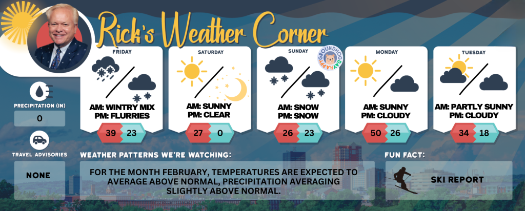
Friday: Cloudy and not as cold with some rain in the afternoon. High 39 Winds: Light & Variable
Friday night: Cloudy with rain to periods of wet snow, accumulating a coating to an inch or two, followed by few flurries by daybreak. Low 23 Winds: NNW 5-10 mph
Saturday (Feb. 1st): Mostly sunny, windy, & cold. High 27 (feel like 15) Winds: NW 15-25+ mph
Saturday night: Mainly clear and frigid. Low 0 (feel like -6) Winds: NNW 5-10 mph
Sunday (Ground Hog Day): Not as cold with snow and flurries late in the afternoon. High 26 (feel like 19) Winds: S 5-10 mph
Sunday night: Periods of light snow (1-2″). Low 23 Winds: Light & Variable
Monday: Mostly cloudy, breezy, and milder. High Near 50 (feel like 42) Winds: SW 10-20+ mph
Monday night: Partly cloudy & breezy. Low 26 (feel like 16) Winds: WNW 10-15 mph
Tuesday: Breezy and colder with some sun & clouds. High 34 (feel like 25) Winds: NW 10-20 mph
Tuesday night: Partly to mostly cloudy. Low 18 (feel like 15) Winds: NW 5-15 mph
Weather Patterns We’re Watching
For the month February, temperatures are expected to average above normal, precipitation averaging slightly above normal.
Skiing and Snowboarding Weather Report
Elevations for summits above 4,000 feet in New Hampshire today: The summits will be obscured, with snow likely to develop in the afternoon. High temperatures will reach the mid-20s. Expect west winds around 35 mph, decreasing to approximately 25 mph later in the afternoon. At elevations above 5,000 feet, west winds will be around 55 mph, decreasing to about 40 mph in the afternoon, with gusts reaching up to 75 mph. There is a 60 percent chance of snow, and wind chill values may drop as low as 7 below zero.
Elevations between 2,500 and 4,000 feet in Northern New Hampshire today: Summits are obscured with a chance of snow in the afternoon. High temperatures will be in the mid-20s. West winds are expected at 10 to 20 mph, with gusts reaching up to 55 mph. The chance of snow is 50 percent.


