
Weekend weather: Friday sun and wind, Saturday showers, with chilly temps back for Sunday
It’s pretty windy today, with a mix of clouds and sun. The high is around 41, but it feels more like 32, with wind gusts coming from the west-northwest at 15-20+ mph.


Rick Gordon’s Weather Watch
Follow our YouTube channel here.
Friday’s Weather
It’s pretty windy today, with a mix of clouds and sun. The high is around 41, but it feels more like 32, with wind gusts coming from the west-northwest at 15-20+ mph.
Weekend Outlook
**Saturday (March 1st) Weather: On Saturday, conditions will be mainly cloudy and breezy, with a few light afternoon showers possible. The daytime high will reach 47°, feeling more like 38°. Winds will be from the southwest at 10-20 mph.
**Saturday Night’s Weather: Saturday night will be partly cloudy, breezy, and cold, with a low of 15° and significant wind chill making it feel like just 1°. Winds will come from the west-northwest at 15-20 mph.
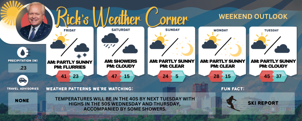
5-Day Outlook
Friday: Windy with some clouds & sun. High 41 (feel like 32) Winds: WNW 15-20+ mph
Friday night: Overcast and breezy. In the evening, light snow is expected to begin, leading to occasional periods of snow later in the night. Accumulation is anticipated to range from a light coating to approximately one or two inches by morning. Low 23 (feel like 4) Winds: SSE 15-20 mph
Saturday (March 1st): Mainly cloudy and breezy with a few spot afternoon showers. High 47 (feel like 38) Winds: SW 10-20 mph
Saturday night: Partly cloudy, breezy, & cold. Low 15 (feel like 1) Winds: WNW 15-20 mph
Sunday: Mainly sunny, windy, and very cold. High 24 (feel like 7) Winds: NW 20-25+ mph
Sunday night: Clear, breezy, & frigid. Low 5 (feel like -9) Winds: NW 10-15 mph
Monday: Sunny, breezy, and very cold. High 28 (feel like 18) Winds: NW 10-15 mph
Monday night: Clear to partly cloudy. Low 15 Winds: Light & Variable
Tuesday: Not as cold with some sun. High 45 Winds: WSW 5-10 mph
Tuesday night: Cloudy. Low 37 Winds: SSW 5-10 mph
Weather Alerts
March arrives like a lion on Saturday, marking the beginning of meteorological spring with another Alberta clipper system producing some rain & snow showers. Sunday will bring some sunshine and cold temperatures, with a gusty wind making the 28 degrees like 15.
Weather Patterns We’re Watching
Temperatures will be in the 40s by next Tuesday with highs in the 50s Wednesday and Thursday, accompanied by some showers.
Skiing and Snowboarding Weather Report
Elevations for summits above 4,000 feet in New Hampshire today: The mountains will be cloudy in the morning but should clear up a bit later on. Expect high temps in the low 20s. Northwest winds will be pretty strong at about 50 mph, dropping to around 40 mph in the afternoon, with gusts hitting up to 85 mph. It’s going to feel super cold too, with wind chills dipping to as low as 22 below!
Elevations between 2,500 and 4,000 feet in Northern New Hampshire today: Looks like we’ll have some peaks poking through the clouds in the morning, but it’s going to get mostly cloudy later on. Expect temps to be in the mid-20s with some pretty strong northwest winds at 20 to 30 mph and gusts hitting up to 70 mph. It’s going to feel really cold, too, with wind chill making it feel like it’s 15 below.


