
Weekend Weather: Fair Friday, high of 55, then return to wintry mix with some accumulation
Start your day with bright morning sunshine that will transition into a blanket of afternoon clouds, accompanied by refreshing breezy conditions. Saturday and Sunday: back to the big chill and a wintry mix.

Rick Gordon’s Weather Watch
Follow our YouTube channel here.
Today’s Weather
Start your day with bright morning sunshine that will transition into a blanket of afternoon clouds, accompanied by refreshing breezy conditions. Expect the high temperature to reach 55 degrees, though it may feel like just 50 degrees. Winds will be coming from the WNW at a brisk 10-15 mph, adding to the invigorating atmosphere.
Weekend Headlines
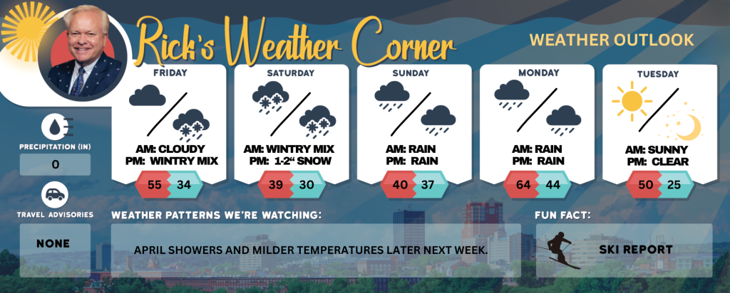
The last weekend of March going out with wintery feel.
Saturday: ** Prepare for a significant drop in temperatures, with a mix of snow and rain that will shift to mainly a cold rain as the day progresses. The high will reach 39°, but it will feel like only 33° due to the wind chill. Expect steady winds from the ENE at 5-15 mph, making it a day to bundle up! Ski country could see 6-10″ of snow!
Saturday Night: ** Conditions will remain overcast, with a wintry mix of snow (accumulating 1-2 inches) and freezing rain. Temperatures will dip to a chilling low of 30°, feeling even colder at 25°. Northeast winds at 5-15 mph will add to the brisk conditions, so be cautious if you’re heading out.
Sunday: ** The morning will bring areas of freezing rain, leading to wet and slippery surfaces. As the day continues, expect periods of rain that could total around 0.25 inches. Temperatures will rise to a high of 40°, but make sure to dress appropriately, as it will feel like 35° with light ENE winds at 5-10 mph.
Sunday Night: ** Rain will persist with drizzle, adding another 0.25 inches to the mix. A low of 37° awaits, along with light winds from the ENE at 5-10 mph. It’s a perfect night to stay cozy indoors!
5-Day Outlook
Friday: Some morning sun giving way to afternoon clouds and breezy. High 55 (feel like 50) Winds: WNW 10-20+ mph
Friday night: Cloudy with rain and snow showers after midnight. Low 34 (feel like 30) Winds: Light & Variable
Saturday: Colder with snow mixed with rain changing to rain. High 39 (feel like 33) Winds: ENE 5-15 mph
Saturday night: Cloudy with a wintery mix of snow (1-2″) & freezing rain. Low 30 (feel like 25) Winds: NE 5-15 mph
Sunday: Areas of freezing rain in the morning followed by periods of rain (.25″). High 40 (feel like 35) Winds: ENE 5-10 mph
Sunday night: Periods of Rain (.25″) & drizzle. Low 37 Winds: ENE 5-10 mph
Monday: Milder & breezy with periods of showers. High 64 Winds: SSW 10-15 mph
Monday night: Mostly cloudy & mild with evening showers or thundershowers. Low 44 Winds: W 10-15 mph
Tuesday (April 1st): Mostly sunny, breezy, and cooler. High 50 (feel like 45) Winds: NW 15-20+ mph
Tuesday night: Mainly clear, breezy, & colder. Low 25 (feel like 22) Winds: NW 10-15 mph
Weather Patterns We’re Watching
April showers and milder temperatures later next week.
Skiing and Snowboarding Weather Report
Elevations for summits above 4,000 feet in New Hampshire Friday: Summits in and out of clouds. A chance of snow showers in the morning. Highs in the mid 20s. Northwest winds 30 to 40 mph with gusts up to 85 mph. Chance of snow 30 percent. Wind chill values as low as 21 below.
Elevations between 2,500 and 4,000 feet in Northern New Hampshire Friday: Summits obscured in the morning, then becoming cloudy. A chance of snow showers in the morning. Highs around 30. West winds 15 to 25 mph with gusts up to 60 mph. Chance of snow 50 percent. Wind chill values as low as 6 below in the morning.