
Weekend Weather: Depths of winter with 3-7 inches of snow Saturday night
Saturday night’s snow is the story for the weekend.


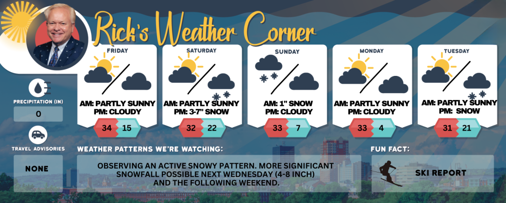
Rick Gordon’s Weather Watch
Follow our YouTube channel here.
Today’s Weather
Prepare for gusty winds occasionally exceeding 40 mph, accompanied by a mix of clouds and sunshine with a passing flurry. The high temperature will reach 34° (though it may feel like 21°). Winds will come from the WNW at 15-25+ mph, so brace yourself for the blustery conditions that can blow around unsecured objects.
Weekend Weather Wrap
Here’s a summary of your weekend. Looks like it’s going to be a wintery weekend!
Saturday: Clouding up with a high of 32°F.
Saturday Night: Snow, becoming heavy at times. Accumulation: 3-7 inches. Expect rapidly deteriorating road conditions, slow and slippery travel.
Sunday: Periods of snow in the morning, up to 1 inch. Storm Total: 4-8 inches. Some sun later in the day. Travel will remain difficult; exercise caution when shoveling. Stay prepared, and make sure to keep that shovel and winter gear handy. Perhaps this would be a good weekend to catch up on indoor activities or enjoy some hot cocoa and the Super Bowl. ☕️❄️ If you need an updated forecast, checking back here might be a good idea. Stay warm and safe!
5-Day Outlook
Today: Gusty winds could occasionally gust over 40 mph with some clouds & sun with a passing flurry. High 34 (feel like 21) Winds: WNW 15-25+ mph
Tonight: Partly cloudy & colder. Low 15 Winds: WNW 5-10 mph
Saturday: Some morning sun followed by clouds. High 32 Winds: WNW 5-10 mph
Saturday night: Snow (3-7″). Low 22 Winds: Light & Variable
Sunday: Early morning snow (1″) with some afternoon sun & windy. High 33 (feel like 25) Winds: NW 10-20 mph
Sunday night: Clear & very cold. Low 7 Winds: Light & Variable
Monday: Sunny & cold. High 33 (feel like 25) Winds: WNW 5-15 mph
Monday night: Mainly clear & very cold. Low 4 Winds: Light & Variable
Tuesday: Some sun with afternoon clouds. High 33 Winds: W 5-10 mph
Tuesday night: Some snow showers (1″). Low 21 Winds: Light & Variable
Weather Patterns We’re Watching
Observing an active snowy pattern. More significant snowfall possible next Wednesday (4-8 inch) and the following weekend.
Skiing and Snowboarding Weather Report
Elevations for summits above 4,000 feet in New Hampshire today: Summits obscured. A chance of snow showers. Highs around 14, except around 8 above at elevations above 5,000 feet. West winds 40 to 50 mph, except west 50 to 70 mph at elevations above 5,000 feet. Chance of snow 50 percent. Wind chill values as low as 31 below.
Elevations between 2,500 and 4,000 feet in Northern New Hampshire today: Summits in and out of clouds. A chance of snow showers. Highs around 17. West winds 25 to 35 mph with gusts up to 75 mph. Chance of snow 50 percent. Wind chill values as low as 19 below.


