
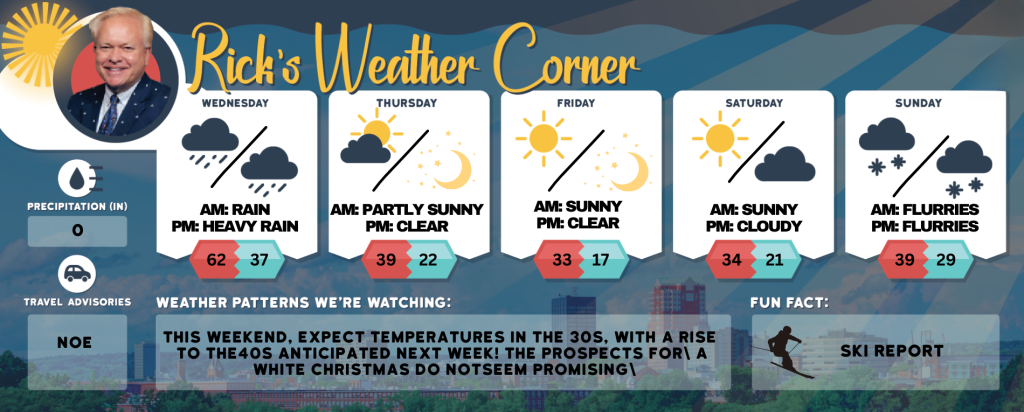
Wednesday’s weather: Wet and windy, high of 62
Windy & very mild with periods of rain (1.25″). Potential for heavy rainfall; there can be flooding in low-lying and poor drainage areas. Near record high of 62 (63 set in 1966) Winds: ESE 15-20+ mph

Rick Gordon’s Weather Watch
Follow our YouTube channel here.
Today’s Weather Outlook
It will be windy with near-record warmth, with periods of rain totaling 1.25 inches. Heavy rainfall is possible, which may cause flooding in low-lying and poorly drained areas. The high temperature will reach 62° (feeling like 51°), with winds from the east-southeast at 15 to 20 mph or more. The record high temperature today is 63, set in 1966.
5-Day Outlook
Today: Windy & very mild with periods of rain (1.25″). Potential for heavy rainfall; there can be flooding in low-lying and poor drainage areas. Near record high of 62 (63 set in 1966) Winds: ESE 15-20+ mph
Tonight: Heavy rain (.80″) early followed by clearing & windy conditions; locally damaging winds gusts over 40 mph can cause widespread power outages. Low 37 (feel like 25) Winds: SW 10-20+ mph
Thursday: Mostly sunny, windy, and colder. High 39 (feel like 29) Winds: W 10-20+ mph
Thursday night: Clear, breezy, and cold. Low 22 (feel like 13) Winds: W 5-15 mph
Friday: Sunny, breezy & cold. High 33 (feel like 25) Winds: WNW 10-15+ mph
Friday night: Clear & very cold. Low 17 Winds: Light & Variable
Saturday: Mostly sunny & cold. High 34 Winds: Light & Variable
Saturday night: Partly to mostly cloudy. Low 21 Winds: Light & Variable
Sunday: Cloudy & cold with a passing snow shower. High 39 Winds: ESE 5-10 mph
Sunday night: Some snow showers (1″). Low 29 Winds: Light & Variable
Weather Alerts
Today’s storm is expected to undergo a rapid drop in central pressure, forming a vast vacuum in the atmosphere and resulting in strong winds. This process, known as bombogenesis, occurs when the central pressure falls by 0.71 inches (24 millibars) or more within 24 hours, which is anticipated for this storm. The resulting bomb cyclone is likely to bring substantial rainfall (1-2+ inches) and possibly severe wind gusts over 40 mph. There is a risk of flash flooding, and coastal regions may suffer from damaging winds.
FLOOD WATCH IN EFFECT FROM WEDNESDAY AFTERNOON THROUGH THURSDAY MORNING.
WHAT: Flooding caused by heavy rain, snowmelt, and ice jams are possible.
WHERE: Portions of Maine, and New Hampshire, including the following areas, Belknap, Cheshire, Eastern Hillsborough, Interior Rockingham, Merrimack, Northern Carroll, Northern Coos, Northern Grafton, Southern Carroll, Southern Coos, Southern Grafton, Strafford, Sullivan and Western and Central Hillsborough.
WHEN: From Wednesday afternoon through Thursday morning. Cold air on the backside of the system will slow runoff on Thursday and end overland flooding, however river responses could last through the end of the week.
IMPACTS: The combination of rain and snowmelt will result in widespread and potentially significant flooding. The heavy rainfall rates could trigger flash flood conditions. For northern streams river ice is expected to move and could result in ice jam flooding.
Weather Patterns We’re Watching
This weekend, expect temperatures in the 30s, with a rise to the 40s anticipated next week! The prospects for a White Christmas do not seem promising at the moment.
Skiing and Snowboarding Weather Report.
Elevations for summits above 4,000 feet in Northern New Hampshire today: Summits will be obscured, with a possibility of freezing rain. Expect highs in the lower 30s. Southwest winds will range from 10 to 20 mph, with gusts up to 35 mph. There is a 40 percent chance of precipitation.
Elevations between 2,500 and 4,000 feet in Northern New Hampshire today: The summits will be obscured. There is a possibility of freezing rain, snow, and sleet in the morning. Expect highs in the lower 30s, with south winds blowing at 10 to 15 mph and gusts reaching up to 30 mph. The chance of precipitation is 50 percent.
Please refer to this link for updates and information on additional ski area openings.
[mailpoet_form id=”3″]