
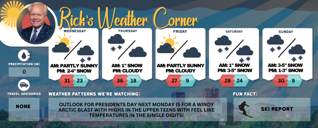
Wednesday’s weather: Partly sunny early on then clouds move in, high of 31
Enjoy a mix of sunshine and clouds this morning but expect overcast skies to take over by the afternoon. The temperature is set to reach a high of 31°, so stay warm!


Rick Gordon’s Weather Watch
Follow our YouTube channel here.
Today’s weather
Enjoy a mix of sunshine and clouds this morning but expect overcast skies to take over by the afternoon. The temperature is set to reach a high of 31°, so stay warm!
5-Day Outlook
Today: Some sun & clouds this morning with skies becoming cloudy this afternoon. High 31 Winds: NE 5-10 mph
Tonight: Expect cloudy conditions with snowfall of 1 to 3 inches beginning after midnight. Plan for a slow and slippery commute in the morning along with school cancellations. Low 23 Winds: E 5-10 mph
Thursday: Morning expects about 1 inch of snow, followed by freezing rain with a cloudy sky this afternoon. High 36 (feel like 31) Winds: NNE 5-10 mph
Thursday night: Partly cloudy, cold, & breezy. Low 18 (feel like 9) Winds: WNW 10-20 mph
Friday: Mostly sunny, windy (gusts near 40 mph), & colder. High 27 (feel like 14) Winds: NW 15-25+ mph
Friday night: Partly cloudy to mostly cloudy & cold. Low 9 Winds: WNW 5-10 mph
Saturday: Cloudy with periods of snow in the afternoon (1″). High 29 Winds: Light & Variable
Saturday night: Watching a potential winter storm. Periods of snow (3-5″) Low 24 Winds: Light & Variable
Sunday: Watching a potential winter storm. Snow during the morning (3-5″) will become a mix of wintry precipitation during the afternoon. High 30 (fee like 21) Winds: N 10-15 mph
Sunday night: Snow (1-3″) in the evening will give way to some clearing overnight. Low 9 (feel like -6) Winds: NW 10-15+ mph
Another winter storm this weekend
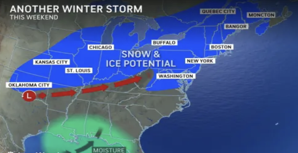
A powerful winter storm is expected to impact New Hampshire this weekend; please check back frequently for updates.
Weather Patterns We’re Watching
Outlook for Presidents Day next Monday is for a windy arctic blast with highs in the upper teens with feel like temperatures in the single digits!
Skiing and Snowboarding Weather Report
Elevations for summits above 4,000 feet in New Hampshire today: Summits obscured. Highs ranging from 8 to 18 degrees. West winds at 15 to 25 mph, gusts up to 45 mph. Wind chill values as low as 34 degrees below.
Elevations between 2,500 and 4,000 feet in Northern New Hampshire today: Summits obscured. Highs 11 to 21. West winds 10 to 15 mph with gusts up to 35 mph.


