
Wednesday’s weather: Partly sunny and humid, late T-storms possible, high of 85
Expect intervals of clouds and sunshine, with a thunderstorm in spots, accompanied by humid conditions and a high of 85 degrees, though it may feel like 89 degrees.


Weather Watch with Rick Gordon
Click below for Rick’s exclusive videocast.
Wednesday’s Weather
Expect intervals of clouds and sunshine, with a thunderstorm in spots, accompanied by humid conditions and a high of 85 degrees, though it may feel like 89 degrees.
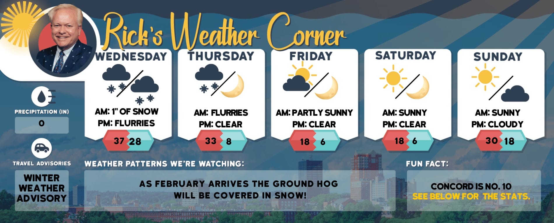
5-Day Outlook, June 5-9Today: The morning is expected to alternate between cloudy and sunny periods, leading up to a humid afternoon with potential thunderstorms. High 85 (feel like 89) Winds: SW 5-10mphTonight: Cloudy, humid, and mild. Low 64 Winds: S 5-10 mphThursday: Expect a cloudy and humid day, not as warm, with occasional showers and a heavy thunderstorm possible. High 73 (feel like 76) Winds: ESE 5-15 mphThursday night: Cloudy & mid with some showers. Low 62 Winds: NE 5-10 mph Friday: Cloudy with some afternoon sun and humid with a few showers. High 76 (feel like 80) Winds: ENE 5-10 mphFriday night: Partly cloudy with a few showers. Low 59 Winds: NE 5-10 mphSaturday: Mostly cloudy with morning showers, followed by occasional showers and a thunderstorm in the afternoon. High 73 (feel like 77) Winds: E 5-10 mphSaturday night: Early showers will decrease in frequency as the night progresses. Low 56 Winds: WNW 5-10 mphSunday: Mostly cloudy with a morning shower passing through, followed by a couple of thundershowers in the afternoon. High 75 Winds: SW 5-10 mphSunday night: Partly cloudy. Low 56 Winds: WSW 5-10 mph
Showers on the Radar
Showers are anticipated to arrive on Thursday due to a low-pressure system advancing from the Ohio Valley. The sporadic showers and thunderstorms may continue throughout the weekend as the system remains over southern New England.
Weather Patterns We’re WatchingMidway through the next week, temperatures are expected to be above average, with highs in the mid-80s.
Hiking/Beach/Lake Forecasts
Take a HikeElevations for summits above 4,000 feet in Northern New Hampshire Today: Summits will be obscured with a possibility of showers. The afternoon may bring scattered thunderstorms. Expect highs in the mid-60s, except for upper 50s at elevations above 5000 feet. Southwest winds will be up to 10 mph, with gusts up to 25 mph. There is a 50 percent chance of rain.Elevations between 2,500 and 4,000 feet in Northern New Hampshire Today: The forecast is mostly cloudy with a possibility of showers. The afternoon may bring scattered thunderstorms. Expect highs in the lower 70s, with light and variable winds. There’s a 50 percent chance of rain.
Hit the Beach
Weather: Mostly sunny. Patchy fog
Thunderstorm Potential: None.
High Temperature: In the lower 70s.
UV Index: High.
Winds: South winds 5 to 10 mph.
Water Temperature: 57 degrees. The US Coast Guard states that if the water temperature falls below 60 degrees, an average person submerged in water may experience a loss of dexterity within minutes, rendering them incapable of performing simple tasks such as fastening a life jacket or using a radio.
Surf Height: Around 1 foot.
Rip Current Risk: Low
Tides Hampton Beach: High 8.7 feet (MLLW) 11:05 AM. Low 0.3 feet (MLLW) 05:15 PM.
Jump in a Lake
Southwest winds will be approximately 5 mph with waves under one foot. Expect partly sunny skies. There’s a slight chance of showers and isolated thunderstorms in the morning, followed by scattered thunderstorms and a chance of showers in the afternoon. Temperatures will reach the upper 70s. The probability of rain is 40 percent. There is a moderate lightning threat, indicating the possibility of thunderstorms. The water temperature will be around 66 degrees Fahrenheit.Precipitation Totals


