
Wednesday’s weather: Cozy sweater weather today – sunshine in the morning, high of 47
The day will kick off with bright sunshine, but as the morning unfolds, those rays will gradually give way to a cloudier sky. Expect a high of 47 degrees, perfect for a cozy sweater!

Rick Gordon’s Weather Watch
Follow our YouTube channel here.
Today’s Weather Outlook
The day will kick off with bright sunshine, but as the morning unfolds, those rays will gradually give way to a cloudier sky. Expect a high of 47 degrees, perfect for a cozy sweater!
5-Day Outlook
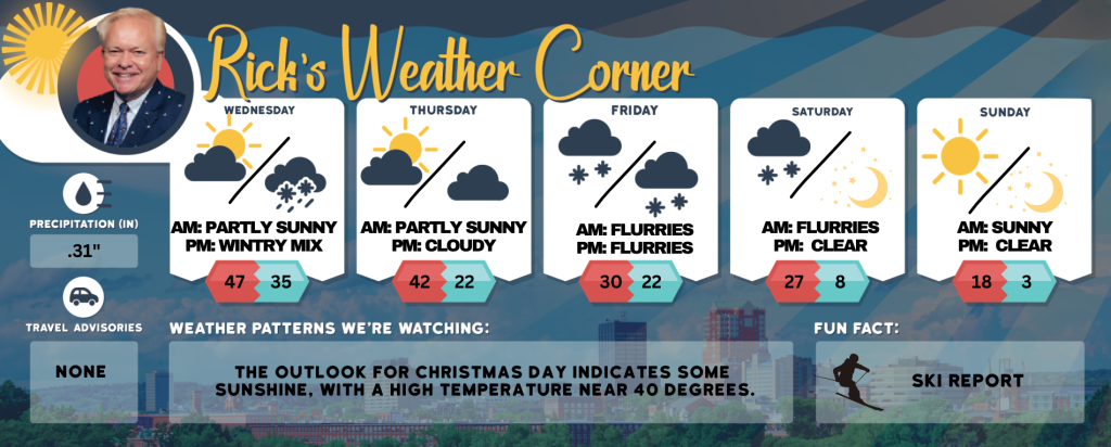
Today: The morning will begin with sunshine, followed by clouds. High 47 Winds: SW 5-10 mph
Tonight: Periods of rain (.25″) mixed with some snow with little or no accumulation. Low 35 Winds: NNE 5-10 mph
Thursday: Some sun, breezy, and turning cooler. High 42 (feel like 34) Winds: NW 10-15 mph
Thursday night: Few clouds & colder. Low 22 Winds: NNW 5-10 mph
Friday: Mainly cloudy and cold with afternoon snow showers. High 30 (feel like 22) Winds: NNE 5-10 mph
Friday night: Some snow showers (Inch or less). Low 22 Winds: N 5-10 mph
Saturday (First Day of Astronomical Winter): Morning flurries with some afternoon sun, windy, and very cold. High 27 (feel like 17) Winds: NW 10-20 mph
Saturday night: Mainly clear & frigid. Low 8 (feel like -2) Winds: NW 10-15 mph
Sunday: Lots of sunshine, breezy, and frigid. High 18 (feel like 5) Winds: NW 15-20+ mph
Sunday night: Clear. breezy, and frigid. Low 3 (feel like -5) Winds: NNW 5-15+ mph
Weather Alert
On the first day of Astronomical Winter, Saturday, December 21, the season’s coldest air will arrive, marking the first weekend of Winter with high temperatures in the mid-20s. A biting wind will make it feel like the teens, and this chilly sensation is expected to persist into the beginning of Christmas week.
Weather Patterns We’re Watching
The outlook for Christmas Day indicates some sunshine, with a high temperature near 40 degrees.
Skiing and Snowboarding Weather Report.
Elevations for summits above 4,000 feet in Northern New Hampshire today: Snow showers are possible in the afternoon with highs near 30 degrees. Westerly winds will be around 30 mph, shifting to the southwest at about 20 mph later in the day. Wind gusts may reach up to 60 mph. There’s a 50 percent chance of snow. Morning wind chill values could drop to as low as 1 degree below zero.
Elevations between 2,500 and 4,000 feet in Northern New Hampshire today: There’s a possibility of intermittent snow showers in the afternoon with temperatures peaking in the lower 30s. Expect west winds of 10 to 20 mph, gusting up to 50 mph. The likelihood of snow is 50 percent.
Please refer to this link for updates and information on additional ski area openings.