
Wednesday’s weather: Cloudy and humid, possible showers, high of 75
Expect cloudy skies with cooler temperatures, accompanied by a few showers, mainly later in the day. The high will be 75 degrees, feeling more like 80.


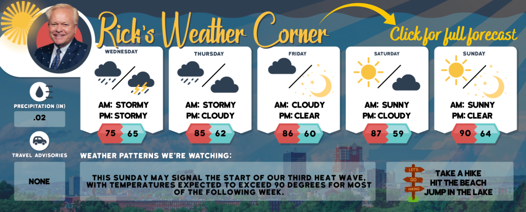
Weather Watch with Rick Gordon
Click below for Rick’s exclusive videocast
Wednesday’s Weather
Expect cloudy skies with cooler temperatures, accompanied by a few showers, mainly later in the day. The high will be 75 degrees, feeling more like 80.
5-Day Forecast July 24-July 28
Today: Cloudy & humid, not as warm temperatures, but with a few showers primarily later in the day. High 75 (feel like 80) Winds: ESE 5-10 mph
Tonight: Cloudy and humid with a thunderstorm in spots. Low 65 Winds: SE 5-10 mph
Thursday: Expect a cloudy and humid day with afternoon showers and a thunderstorm; storms can bring flooding downpours and localized damaging wind gusts. High 85 (feel like 89) Winds: SW 10-15 mph
Thursday night: Partly cloudy and turning less humid. Low 62 Wins: WNW 5-10 mph
Friday: Mostly sunny, breezy, and comfortable. High 86 Winds: NW 10-15mph
Friday night: Mainly clear. Low 60 Winds: NW 5-10 mph
Saturday: Mostly sunny & nice. High 87 Winds: Light & Variable
Saturday night: Partly cloudy. Low 59 Winds: Light & Variable
Sunday: Mostly sunny, hot, and more humid. High 90 (feel like 95) Winds: SW 5-10 mph
Sunday night: Mainly clear and humid. Low 64 Winds: S 5-10 mph
Weather Patterns We’re Watching
This Sunday may signal the start of our third heat wave, with temperatures expected to exceed 90 degrees for most of the following week.
Hiking/Beach/Lake Forecasts
Take a Hike
Elevations for summits above 4,000 feet in Northern New Hampshire Today: The summits will be obscured with a possibility of showers. Expect highs around 60 degrees. South winds will be up to 10 mph, with gusts up to 20 mph. There is a 50 percent chance of rain.
Elevations between 2,500 and 4,000 feet in Northern New Hampshire Today: Expect cloudy skies with a possibility of showers. Temperatures will reach the mid-60s. Southeast winds will be gentle at up to 10 mph, with gusts potentially reaching 20 mph. There’s a 50 percent chance of rain.
Hit the Beach
- Weather: Overcast skies, intermittent fog, and a possibility of rain showers.
- UV Index: Moderate.
- Thunderstorm Potential: Low. Implies that there is little chance of thunderstorms.
- High Temperature: Around 70.
- Winds: East winds 5 to 10 mph.
- Water Temperature: 62 degrees.
- Surf Height: Around 2 feet.
- Rip Tide Current Risk: Low.
- Tides Hampton Beach: Low tide at -1.0 feet (Mean Lower Low Water) will occur at 08:26 AM, followed by a high tide of 9.1 feet (Mean Lower Low Water) at 02:25 PM.
Jump in a Lake
Expect east winds at approximately 5 mph with wave heights around one foot. The morning may bring patchy fog, followed by cloudy skies and a possibility of showers. The afternoon could see isolated thunderstorms. It will be humid with high temperatures in the lower 70s. There’s a 50 percent chance of rain. The threat of lightning is low, indicating a minimal chance of thunderstorms. The water temperature will be around 76 degrees.


