
Wednesday’s weather: Cloudy, hot and humid with severt T-storms that could lead to flash flooding
Expect cloudy conditions, high humidity, and heat, accompanied by intense thunderstorms. These storms may lead to flash flooding, destructive winds, and considerable delays in travel.


Weather Watch with Rick Gordon
Click below for Rick’s exclusive videocast
Wednesday’s Weather
Anticipate cloudy skies, elevated humidity, and heat, along with severe thunderstorms. These conditions could result in flash floods, damaging winds, and significant travel disruptions. The high will be 93 degrees, feeling like 99.
Weather Alert
Today is the fifth straight day of 90-degree weather, marking the second heat wave, with temperatures expected to remain at or above 90 degrees until next Wednesday. The incoming effects from Beryl are expected to impact Manchester between 10 p.m. Wednesday through 8 a.m. Thursday with wind gusts of 13 mph and 1-2 inches of rain.
5-Day Forecast July 10-July 14
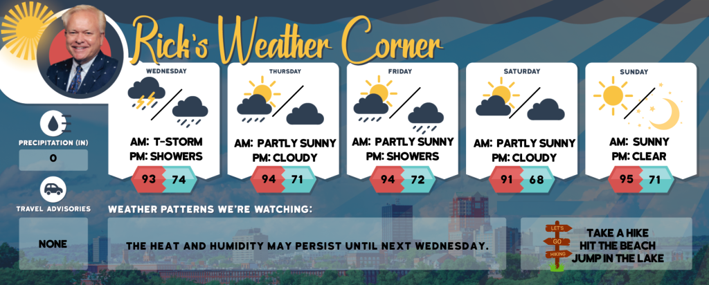
Today: Expect cloudy conditions, high humidity, and heat, accompanied by intense thunderstorms. These storms may lead to flash flooding, destructive winds, and considerable delays in travel. High 93 (feel like 99) Winds: SSW 5-15 mph
Tonight: Tropical feel with occasional showers and thunderstorms due to a tropical rainstorm. Low 74 Winds: S 5-15 MPH
Thursday: Expect hot & humid conditions with intermittent cloud cover and a chance of afternoon thunderstorms. There is a risk of dehydration and heatstroke during vigorous activities. High 94 (feel like 97) Winds: SSW 10-15 mph
Thursday night: Some clouds & humid. Low 71 Winds: SSW 5-10 mph
Friday: Some sun, hot, and not as humid. High 94 (feel like 93) Winds: WNW 10-15 mph
Friday night: Mostly cloudy & humid; expect a few showers late at night. Low 72 Winds: WSW 5-10 mph
Saturday: Hot & humid with intervals of clouds and sunshine. High 91 (feel like 93) Winds: WSW 5-10 mph
Saturday night: Some clouds and humid. Low 68 Winds: Light & Variable
Sunday: Mostly sunny, hot, and humid. High 95 (feel like 98) Winds: WSW 5-10 mph
Sunday night: Mainly clear, warm, and humid. Low 71 Winds: Light& Variable
Weather Patterns We’re Watching
The heat and humidity may persist until next Wednesday.
Hiking/Beach/Lake Forecasts
Take a Hike
Elevations for summits above 4,000 feet in Northern New Hampshire Today: The summits will be obscured. There’s a likelihood of showers and a possibility of thunderstorms in the afternoon. Expect highs around 70 degrees. Westerly winds will be blowing at 10 to 20 mph, with gusts reaching up to 45 mph. The chance of rain is 70 percent.
Elevations between 2,500 and 4,000 feet in Northern New Hampshire Today: Summits will appear intermittently through the clouds. There’s a likelihood of showers and a possibility of thunderstorms in the afternoon. Expect highs in the mid-70s, with west winds at 10 to 15 mph, gusting up to 30 mph. The chance of rain is 70 percent.
Hit the Beach
- Weather: Partly sunny with a possibility of showers and thunderstorms.
- UV Index: High.
- Thunderstorm Potential: Partly sunny. A chance of showers and thunderstorms.
- High Temperature: Around 80.
- Winds: Southwest winds around 5 mph, becoming southeast in the afternoon.
- Water Temperature: 62 degrees.
- Surf Height: Around 2 feet.
- Rip Tide Current Risk: Low.
- Tides Hampton Beach: Low 0.3 feet (MLLW) 09:30 AM. High 8.0 feet (MLLW) 03:29 PM.
Jump in a Lake
Southwest winds around 5 mph shifting to the east in the afternoon. Expect waves around 1 foot. The morning will be partly sunny with a slight chance of showers and thunderstorms, becoming mostly cloudy in the afternoon with a higher likelihood of showers and possible thunderstorms. It will be humid with temperatures peaking in the lower 80s. There’s a 60 percent chance of rain. The moderate lightning threat indicates that thunderstorms are possible. The water temperature will be around 76 degrees.


