
Tuesday’s weather: Rain then sun, with gusty winds, high of 56
Get ready for an intriguing start to your day! Early morning showers with 0.10 inches of rain will allow bright afternoon sunshine. Enjoy the pleasant breeze and milder temperatures as the day progresses, with a high reaching 56 degrees, though it may feel a bit cooler at 49°.

Rick Gordon’s Weather Watch
Follow our YouTube channel here.
Today’s Weather Outlook
Get ready for an intriguing start to your day! Early morning showers with 0.10 inches of rain will allow bright afternoon sunshine. Enjoy the pleasant breeze and milder temperatures as the day progresses, with a high reaching 56 degrees, though it may feel a bit cooler at 49°. Don’t forget to brace yourself for gusty southerly winds, whipping at 15-20+ mph! Embrace the weather and make the most of your day!
5-Day Outlook
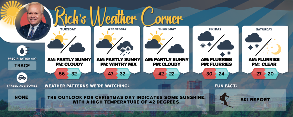
Today: Early morning showers (.10″) with afternoon sunshine, breezy, and milder. High 56 (feel like 49) Winds: SSW 15-20+ mph
Tonight: Partly cloudy. Low 32 Winds: W 5-10 mph
Wednesday: The morning will begin with sunshine, followed by clouds and showers in the afternoon. High 47 Winds: SW 5-10 mph
Wednesday night: Showers to light snow (1-3″) late. Low 32 Winds: Light & Variable
Thursday: Some sun, breezy, and turning cooler. High 42 (feel like 34) Winds: NW 10-20 mph
Thursday night: Few clouds & colder. Low 22 Winds: Light & Variable
Friday: Mainly cloudy and cold with afternoon snow showers (1″). High 30 (feel like 22) Winds: NNE 5-15 mph
Friday night: Some snow showers (1″). Low 24 Winds: N 5-10 mph
Saturday (First Day of Astronomical Winter): Morning flurries or snow showers with some afternoon sun, windy, and very cold. High 27 (feel like 17) Winds: NW 10-20 mph
Saturday night: Mainly clear & frigid. Low 6 Winds: NW 5-10 mph
Weather Alert
On the first day of Astronomical Winter, Saturday, December 21, there will be morning flurries and snow showers, with high temperatures reaching the mid20s, while a frigid wind make it feel like the-teens. The frigid feel will last into the start of Christmas week!!!
Weather Patterns We’re Watching
The outlook for Christmas Day indicates some sunshine, with a high temperature of 38 degrees.
Skiing and Snowboarding Weather Report.
Elevations for summits above 4,000 feet in Northern New Hampshire today: Summits will be obscured in the morning, with rain likely during this time. High temperatures are expected to reach the upper 30s. West winds will range from 35 to45 mph, At elevations above 5,000 feet, west winds will be 70 mph, decreasing to around 55 mph in the. There is a 70 percent chance of, with wind chill values potentially dropping as low as 4 degrees zero
Elevations between 2,500 and 4,000 feet in Northern New Hampshire today: The summits will be obscured the morning. Rain expected in the morning, followed a chance of snow showers in the. temperatures will be around 40 degrees Winds from the west will range from 20 to 3
Please refer to this link for updates and information on additional ski area openings.