
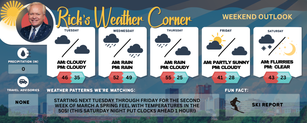
Tuesday’s weather: Partly sunny, milder, high of 46
Early March storm to increase flood risk in New England. Temperatures are expected to rise, heavy rain will occur, and significant snowmelt in New England may increase the risk of flooding in the middle of the first week of March.


Rick Gordon’s Weather Watch
Follow our YouTube channel here.
Today’s Weather
Experience a milder day with a delightful blend of sunshine and clouds! The temperature is expected to reach a high of 46°, although it may feel slightly cooler at 41°. Enjoy a refreshing southwest breeze at 10 to 15 mph as you make the most of the day!
Weather Alerts
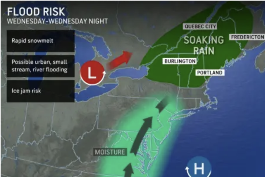
Early March storm to increase flood risk in New England. Temperatures are expected to rise, heavy rain will occur, and significant snowmelt in New England may increase the risk of flooding in the middle of the first week of March.
5-Day Outlook
Today: Milder with some sun & clouds. High 46 (feel like 41) Winds: SW 10-15 mph
Tonight: Partly to mostly cloudy & mild. Low 35 Winds: SSW 5-10 mph
Wednesday: Periods of rain (.25″), breezy, & mild. High 52 Winds: S 10-15+ mph
Wednesday night: Mild & windy with rain (.50″) with street flooding possible. Low 49 (feel like 41) Winds: S 15-25+ mph
Thursday: Cloudy and mild with some rain showers. High 55 (feel like 50) Winds: WSW 5-10 mph
Thursday night: Some clouds, colder, and breezy. Low 25 (feel like 12) Winds: WNW 15-25+ mph
Friday: Very windy with some sun & clouds. High 41 (feel like 29) Winds: WNW 20-30+ (gusts over 40 mph possible)
Friday night: Partly to mostly cloudy & breezy. Low 28 (feel like 20) Winds: W 10-20 mph
Saturday: An early snow flurry with some afternoon sun & breezy. High 43 (feel like 38) Winds:
Saturday night (Put clocks ahead 1 hour before you go to bed.): Becoming clear & cold. Low 23 (feel like 18) Winds: WNW 10-15 mph
Weather Patterns We’re Watching
Starting next Tuesday through Friday for the second week of March a spring feel with temperatures in the 50s! (This Saturday night put clocks ahead 1 hour!)
Skiing and Snowboarding Weather Report
Elevations for summits above 4,000 feet in New Hampshire today: The summits are obscured with scattered snow showers expected in the afternoon. High temperatures will reach the upper 20s, accompanied by west winds of 20 to 30 mph. At elevations above 5,000 feet, west winds will be around 40 mph, increasing to about 50 mph in the afternoon, with gusts possibly reaching up to 70 mph. There is a 30 percent chance of snow. In the morning, wind chill values could drop as low as -19 degrees Fahrenheit.
Elevations between 2,500 and 4,000 feet in Northern New Hampshire today: Cloudy. Highs in the lower 30s. West winds 10 to 20 mph with gusts up to 55 mph.


