
Tuesday’s weather: Partly sunny and hot, possible afternoon T-storm, high of 93
Anticipate a sweltering day with intervals of sunshine giving way to clouds, and the possibility of scattered thunderstorms in the afternoon. Some of the storms could turn severe. There’s an increased risk of dehydration and heatstroke during intense activities. The high will be 93, feeling like 99.


Weather Watch with Rick Gordon
Click below for Rick’s exclusive videocast
Tuesday’s Weather
Anticipate a sweltering day with intervals of sunshine giving way to clouds, and the possibility of scattered thunderstorms in the afternoon. Some of the storms could turn severe. There’s an increased risk of dehydration and heatstroke during intense activities. The high will be 93, feeling like 99.
Weather Alert
Today marks the fourth consecutive day of 90-degree weather, constituting our second heat wave, and temperatures are expected to remain above 90 degrees through Wednesday.
The incoming effects from Beryl are expected to impact Manchester between midnight and 8 a.m.Thursday with wind gusts between 7-11 mph and 1-2 inches of rain.
5-Day Forecast July 9-July 13
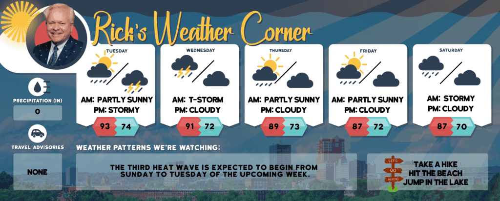
Today: Expect a hot day with periods of sunshine followed by cloud cover, and a chance of isolated thunderstorms in the afternoon. A few storms may be severe. There is a potential risk of dehydration and heatstroke during vigorous activities. High 93 (feel like 99) Winds: SW 10-15 mph
Tonight: A couple of evening thunderstorms; otherwise, partly to mostly cloudy, warm, and humid Low 74 Winds: SSW 5-10 mph
Wednesday: Hot & muggy with a stray thunderstorm. High 91 (feel like 95) Winds: SW 5-10 mph
Wednesday night: Cloudy and muggy with occasional showers and thunderstorms due to a tropical rainstorm. Low 72 Winds: s 5-15 MPH
Thursday: Muggy & very warm with periods of clouds and sunshine; a couple of showers and thunderstorms possible in the afternoon High 89 (feel like 94) Winds: SSW 10-15 mph
Thursday night: A couple of evening showers and a thunderstorm; otherwise, muggy and warm. Low 73 Winds: SSW 5-10 mph
Friday: Muggy, breezy & very warm with intervals of clouds and sunshine with spot showers and a thunderstorm in the afternoon. High 87 (feel like 92) Winds: SW 10-15 mph
Friday night: Few clouds, muggy and warm. Low 72 Winds: SSW 5-10 mph
Saturday: Anticipate a humid and quite warm day with considerable cloud cover; expect scattered showers in the morning, then a few thunderstorms may occur in the afternoon. High 87 (feel like 93) Winds: WSW 5-10 mph
Saturday night: Mostly cloudy and humid. Low 70 Winds: Light & Variable
Weather Patterns We’re Watching
The third heat wave is expected to begin from Sunday to Tuesday of the upcoming week.
Hiking/Beach/Lake Forecasts
Take a Hike
Elevations for summits above 4,000 feet in Northern New Hampshire Today: The morning will be mostly cloudy, followed by intermittent sun and clouds. There’s a possibility of showers and thunderstorms in the afternoon. Expect highs in the lower 70s, except in the upper 60s at elevations above 5,000 feet. Southwest winds will range from 10 to 15 mph, with gusts up to 40 mph. The chance of rain is 30 percent.
Elevations between 2,500 and 4,000 feet in Northern New Hampshire Today: The forecast is mostly cloudy with a possibility of showers and thunderstorms in the afternoon. Temperatures will reach the upper 70s. Expect southwest winds at speeds of up to 10 mph, gusting to 30 mph. There’s a 40 percent chance of rain.
Hit the Beach
- Weather: Partly sunny. Patchy fog. A slight chance of showers and thunderstorms.
- UV Index: Moderate
- Thunderstorm Potential: Low. Implies that there is little chance of thunderstorms.
- High Temperature: In the upper 70s.
- Winds: South winds 5 to 10 mph.
- Water Temperature: 61 degrees.
- Surf Height: Around 2 feet.
- Rip Tide Current Risk: Low.
- Tides Hampton Beach: Low 0.1 feet (MLLW) 08:50 AM. High 8.0 feet (MLLW) 02:47 PM.
Jump in a Lake
Southwest winds will be blowing at 5 to 10 mph, with waves approximately 1 foot high. The day will be mostly sunny, with the possibility of afternoon showers and thunderstorms. It will be humid, with temperatures reaching the mid-80s. There’s a 30 percent chance of rain. The moderate lightning threat indicates that thunderstorms could occur. The water temperature will be around 73 degrees.


