
Tuesday’s weather: Light snow early, high of 33
On Christmas Eve, intermittent snowfall will end around noon, accumulating to a coating of up to one inch. Total storm snowfall is expected to reach one to two inches. Roads may be slippery, and the temperature will be 33 degrees.

Rick Gordon’s Weather Watch
Follow our YouTube channel here.
Today’s Weather Outlook
On Christmas Eve, intermittent snowfall will end around noon, accumulating to a coating of up to one inch. Total storm snowfall is expected to reach one to two inches. Roads may be slippery, and the temperature will be 33 degrees.
5-Day Outlook
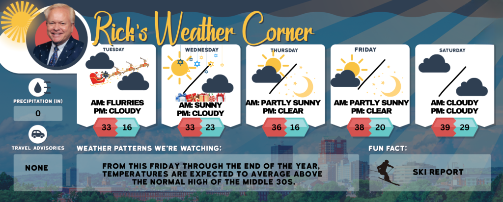
Christmas Eve day: Intermittent snowfall ending by 11 a.m., accumulating to a coating of up to an inch; total storm snowfall of one to two inches; roads may be slippery. High 33 Winds: NE 5-10 mph
Christmas Eve night: Santa will have good weather; partly cloudy & cold. Low 16 Winds: Light & Variable
Christmas & First Day of Hanukkah: Mostly sunny & cold. High 33 Winds: NNW 5-10 mph
Wednesday night: Partly to mostly cloudy. Low 23 Winds: Light & Variable
Thursday: Some sun & clouds. High 36 Winds: Light & Variable
Thursday night: Becoming clear & cold. Low 16 Winds: Light & Variable
Friday: Mostly sunny & milder. High 38 Winds: N 5-10 mph
Friday night: Mainly clear. Low 20 Winds: Light & Variable
Saturday: Morning sun with some afternoon clouds and mild. High 39 Winds: Light & Variable
Saturday night: Mostly cloudy & mild. Low 29 Winds: Light & Variable
Weather Alert
As the Christmas and First Day of Hanukkah holidays rapidly approach and celebrations commence, residents across New England are projected to experience pre-holiday storminess. While the approaching storm present difficulties for some travelers in the region, it will also enhance the likelihood of snow enthusiasts experiencing a White Christmas. On Christmas Eve day, a clipper storm will move across New Hampshire, bringing snowflakes throughout the region. A general accumulation of 1-2 inches of snow is expected, with 3 -6 inches over the White Mountains.
Weather Patterns We’re Watching
From this Friday through the end of the year, temperatures are expected to average above the normal high of the middle 30s.
Skiing and Snowboarding Weather Report.
Elevations for summits above 4,000 feet in Northern New Hampshire today: Summits will be obscured in the morning with intermittent clouds during the afternoon. Snow is likely in the morning, with highs around 16 degrees. Northwest winds will range from 15 to 30 mph with gusts up to 55 mph. The chance of snow is 70. Wind chill values may drop as low as16 below.
Elevations between 2,500 and 4,000 feet in Northern New Hampshire today: Summits will be obscured in the morning, with summits in and of clouds. Snow is likely in the morning. Winds will range from 14 to 24. Northwest winds will 10 15 mph with gusts up to 40 mph. Chance snow is 70 percent.