
Tuesday’s weather: Hot and muggy, high of 98
It sounds like you’re in for a steamy day! With temperatures reaching 98°F and feeling like 102°F, make sure to stay hydrated and find some shade. Those afternoon thunderstorms might bring a bit of relief, but the humidity will still be high.


Weather Watch with Rick Gordon
Click below for Rick’s exclusive videocast
Tuesday’s Weather
It sounds like you’re in for a steamy day! With temperatures reaching 98°F and feeling like 102°F, make sure to stay hydrated and find some shade. Those afternoon thunderstorms might bring a bit of relief, but the humidity will still be high.
Weather Alert
Today is the eleventh straight day of 90-degree weather, making the second heat wave lasting over a week, with temperatures expected to remain at or above 90 degrees through Wednesday. Yesterday’s high broke the record of 95 set in 1955.
5-Day Forecast July 15-July 19
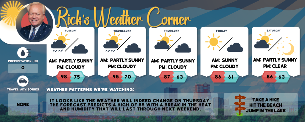
Today: Some sun, very hot, & muggy with a spot afternoon thunderstorm. High 98 (feel like 102) Winds: WSW 10-15 mph
Tonight: A thunderstorm in spots in the evening; otherwise, mainly clear, muggy, and warm. Low 75 Winds: SW 5-10 mph
Wednesday: Hot with clouds and sun; watch for a severe afternoon thunderstorm; thunderstorms can bring flooding downpours, hail, and damaging wind gusts. High 95 (feel like 99) Winds: WSW 10-15 mph
Wednesday night: Cloudy and humid; a couple of evening showers followed by occasional rain and a thunderstorm late. Low 70 Winds: WSW 5-10 mph
Thursday: Not as hot and turning less humid with some sun. High 87 Winds: WNW 5-15 mph
Thursday night: Some clouds. Low 63 Winds: NW 5–10 mph
Friday: Mostly sunny & comfortable. High 86 Winds: WNW 5-10 mph
Friday night: Few clouds. Low 61 Winds: W 5-10 mph Saturday: Very warm with a mix of sun and clouds. High 89 Winds: W 5-10 mph Saturday night: Mainly clear. Low 64 Winds: WSW 5-10 mph
Weather Patterns We’re Watching
It looks like the weather will indeed change on Thursday. The forecast predicts a high of 87 with a break in the heat and humidity that will last through the weekend.
Hiking/Beach/Lake Forecasts
Take a Hike
Elevations for summits above 4,000 feet in Northern New Hampshire Today: It sounds like a mixed day ahead! Expect some clouds around the summits, with a chance of morning showers and thunderstorms. Temperatures will reach the mid-70s, but if you’re heading above 5000 feet, it will be cooler, in the upper 60s. West winds will be quite strong, blowing at 10 to 20 mph with gusts up to 35 mph. There’s a 40% chance of rain, so you might want to keep an umbrella handy!
Elevations between 2,500 and 4,000 feet in Northern New Hampshire Today: It sounds like the weather is going to be quite dynamic! Expect some clouds around the summits, with a possibility of morning showers and thunderstorms. Temperatures will reach the upper 70s, and you’ll feel a west wind blowing at 10 to 15 mph, with gusts up to 30 mph. There’s a 40% chance of rain, so you might want to keep an umbrella handy just in case.
Hit the Beach
- Weather: Mostly sunny. Patchy fog.
- UV Index: High.
- Thunderstorm Potential: None.
- High Temperature: In the upper 80s.
- Winds: Southwest winds around 10 mph
- Water Temperature: 61 degrees.
- Surf Height: Around 2 feet.
- Rip Tide Current Risk: Low.
- Tides Hampton Beach: High 7.0 feet (MLLW) 07:47 AM. Low 1.8 feet (MLLW) 01:55 PM.
Jump in a Lake
It sounds like a mostly pleasant day with west winds at 10 mph and waves around 2 feet. The weather will be mostly sunny, with a slight chance of morning showers and thunderstorms. It’s going to be humid with highs in the upper 80s, and there’s a 20% chance of rain. The lightning threat is low, so thunderstorms are unlikely. The water temperature is a comfortable 78 degrees. Enjoy your day!


