
Tuesday’s weather: Delightful last day of 2024, partly sunny, high of 48
Celebrate New Year’s Eve in delightful weather! Enjoy a mild day with a perfect blend of sun and clouds, reaching a high of 48°.

Rick Gordon’s Weather Watch
Follow our YouTube channel here.
Today’s Weather Outlook
Celebrate New Year’s Eve in delightful weather! Enjoy a mild day with a perfect blend of sun and clouds, reaching a high of 48°. It’s the ideal backdrop for your festivities! As New Year’s Eve rolls in, the night sky is draped in clouds. A gentle breeze stirs the atmosphere, and as the clock strikes midnight, expect rain to hold off until after midnight—about half an inch—embracing the start of the new year. With temperatures hovering around a mild 39 degrees, it’s the perfect backdrop for cozy gatherings and warm wishes as we bid farewell to the old and welcome in the new!
5-Day Outlook
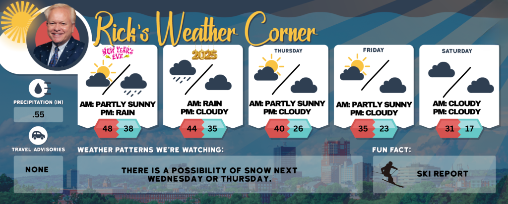
New Year’s Eve Day: Mild with some sun & clouds. High 48 Winds: Light & Variable
New Year’s Eve Night: Cloudy & breezy with rain (.50″) after midnight. Low of 38 (midnight 39). Winds: ENE 10-15 mph
New Year’s Day: Periods of morning rain (.25″}, breezy, and not as mild. High 44 (feel like 36) Winds: WNW 10-15+ mph
Wednesday night: Mainly cloudy & breezy. Low 35 (feel like 24) Winds: W 10-20+ mph Thursday: Stong winds & colder with sun & clouds. High 40 (feel like 26) Winds: WNW 15-25+ with gusts over 40 mph
Thursday night: Partly cloudy & windy. Low 26 (feel like 16) Winds: W 15-20+ mph Friday: Windy with some sun & clouds. High 35 (feel like 22) Winds: W 15-20+ with gusts over 30 mph
Friday night: Partly cloudy & cold. Low 23 (feel like 15) Winds: W 5-15+ mph
Saturday: Partly to mostly cloudy and breezy. High 31(feel like 17) Winds: WNW 10-15 mph
Saturday night: Partly cloudy, breezy, & cold. Low 17 (feel like 7) Winds: NW 10-15 mph
An arctic chill is approaching!
The first weekend of 2025 will be exceptionally cold, with low temperatures in the teens and highs reaching only around 30 degrees. The first full week of January high temperatures staying below freezing with lows in the teens.
Weather Patterns We’re Watching
There is a possibility of snow next Wednesday or Thursday.
Skiing and Snowboarding Weather Report.
Elevations for summits above 4,000 feet in Northern New Hampshire today: Summits will be obscured. Highs will reach the lower 30s. West winds will around 40 mph, decreasing to around 25 mph in the afternoon. Gusts may reach up to70. Wind chill values could be as low as 6 below in the morning.
Elevations between 2,500 and 4,000 feet in Northern New Hampshire today: Summits in and out of clouds in the morning, then becoming cloudy. Highs in the mid 30s. West winds around 25 mph decreasing to around 15 mph in the afternoon. Gusts up to 55 mph. Wind chill values as low as 4 above.