
Tuesday’s weather: Brisk, sunny, windy winter vibe, high of 23 degrees (feels like 3)
Get ready for a day filled with sunshine and blustery winds! With temperatures only reaching a brisk 23°, it will feel more like a chilly 3°. These strong gusts could whip up over 40 mph at times, so bundle up and brace yourself for some serious winter vibes!


Rick Gordon’s Weather Watch
Follow our YouTube channel here.
Today’s weather
Get ready for a day filled with sunshine and blustery winds! With temperatures only reaching a brisk 23°, it will feel more like a chilly 3°. These strong gusts could whip up over 40 mph at times, so bundle up and brace yourself for some serious winter vibes!
5-Day Outlook
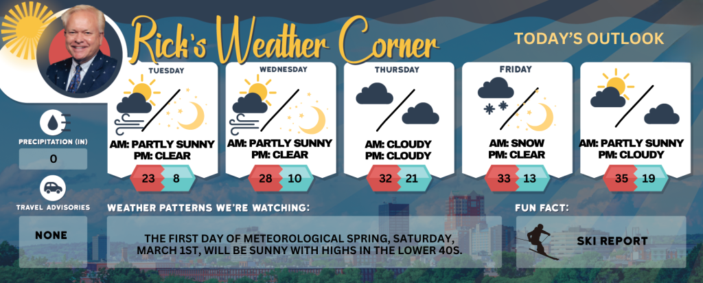
Today: Mostly sunny, very windy (winds could occasionally gust over 40 mph), and very cold. High 23 (feel like 3) Winds: WNW 20-30+ mph
Tonight: Clear to partly cloudy, breezy, and frigid. Low 8 (feel like -9) Winds: WNW 10-20 mph
Wednesday: Breezy and cold with some sun & clouds. High 28 (feel like 15) Winds: WNW 10-15 mph
Wednesday night: Some clouds & very cold. Low 10 (feel like 7) Winds: NW 5-10 mph
Thursday: Cloudy & cold. High 32 (feel like 21) Wind: NW mph5-10 mph
Thursday night: Cloudy & cold. Low 21 (feel like 7) Winds: NW 10-15 mph
Friday: Clouds to sunshine and windy. High 33 (feel like 20) Winds: NW 15-20+ mph
Friday night: Clear & breezy. Low 13 (feel like 3) Winds: NW 10-15 mph
Saturday: Sunshine giving way to some clouds. High 35 Winds: WNW 5-10 mph
Saturday night: Mainly cloudy. Low 19 Winds: WNW 5-10 mph
Weather Outlook
The winter storm on Thursday is to remain to our south over the Virginias and North Carolina, resulting in a cloudy and cold day for us.
Weather Patterns We’re Watching
The first day of Meteorological Spring, Saturday, March 1st, will be sunny with highs in the lower 40s.
Skiing and Snowboarding Weather Report
Elevations for summits above 4,000 feet in New Hampshire today: Summits obscured. Scattered snow showers in the morning. Blowing snow. Visibility one quarter mile or less at times. Highs around 6 below. Northwest winds 45 to 55 mph. At elevations above 5,000 feet, west winds around 85 mph becoming northwest and decreasing to around 75 mph in the afternoon. Gusts up to 130 mph. Chance of snow 30 percent. Wind chill values as low as 62 below.
Elevations between 2,500 and 4,000 feet in Northern New Hampshire today: Summits in and out of clouds. Blowing snow. Scattered snow showers in the afternoon. Visibility one quarter mile or less at times. Highs 7 below to 3 above zero. West winds around 45 mph decreasing to around 35 mph in the afternoon. Gusts up to 95 mph. Chance of snow 50 percent. Wind chill values as low as 51 below.


