
Tuesday’s weather: Breezy, cold with sun giving way to clouds, high of 38 + snow totals!
Today is mainly dry, cooler with partial sunshine this morning with afternoon clouds with a high in the upper 30s. Tonight a passing flurry with a low in the upper 29s.

Weather Watch with Rick Gordon
Below: Watch your weather outlook via YouTube, delivered in two minutes.
Tuesday’s WeatherToday is mainly dry, cooler with partial sunshine this morning with afternoon clouds with a high in the upper 30s. Tonight a passing flurry with a low in the upper 29s.
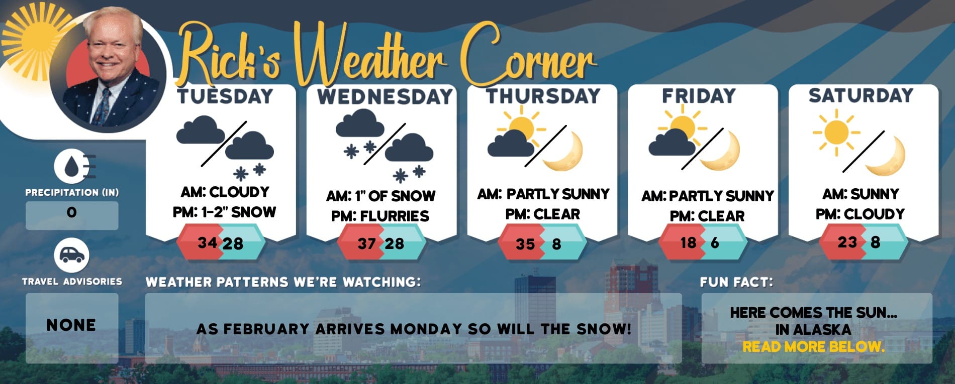
5-Day Outlook, Dec. 5 – 9Today: Some morning sun with afternoon clouds, breezy, and cold. High 38 (feel like 34) Winds: NNW 5-10 mphTonight: Cloudy with a passing flurry. Low 27 (feel like 25) Winds: N 5-10 mphWednesday: Cloudy with some afternoon sun & cold. High 35 (feel like 28) Winds: N 5-10 mphWednesday night: Some clouds & very cold. Low 19 (feel like 13) Winds: NNW 5-10 mphThursday (Hanukkah begins): Some sun & cold. High 35 (feel like 31) Winds: NW 5-10 mphThursday night: Clouding up and not as cold. Low 26 Winds: Light & VariableFriday: Mostly cloudy and milder. High 43 Winds: E 5-10 mphFriday night: Some clouds. Low 32 Winds: Light & VariableSaturday: Some clouds with breaks of sun & mild. High 48 Winds: Light & VariableSaturday night: Partly cloudy. Low 35 Winds: Light & Variable
Snow Totals from Sunday
Belknap County
- New Hampton 6.5″
- Meredith 5.8″
- Belmont 3.0″
- Laconia 1.0 “
Carroll County
- Albany 8.0″
- Jackson 8.0″
- Center Sandwich 6.5″
- North Conway 5.9″
- Wolfeboro 4.8″
- Brookfield 3.0″
Cheshire County
- Rindge 0.5″
- West Chesterfield Trace
- Keene Trace
Coos County
- Gorham 11.5 “
- Pinkham Notch 8.0″
- Berlin 7.0″
- Carroll 6.4″
- Lancaster 2.5″
- Pittsburg 2.0 “
Grafton County
- Waterville Valley 9.7″
- Ashland 8.5″
- Littleton 5.5″
- Holderness 5.0″
- Woodstock 5.0″
- Bristol 4.2″
- Plymouth 4.0″
- Hanover 3.7″
- Sugar Hill 2.8″
- Hanover 2.7″
Hillsborough County
- Windsor 2.2″
- Hillsborough 1.8″
- Manchester Airport Trace (Record rainfall 0.79″ old record 0.69″ 2007)
- Nashua 1.0″
- Greenville 1.0″
- Antrim 0.2″
Merrimack County
- Northfield 5.8″
- Danbury 5.2″
- New London 4.5″
- Contoocook 4.0″
- Henniker 2.0″
- Contoocook 1.5″
- Bow 0.7″
- Concord 0.5″
Rockingham County
- Exeter 6.5″
- Deerfield 0.8″
- Derry Trace
- Epping Trace
- Newington Trace
Weather Patterns We’re Watching
This week will have some sun and cold with temperatures below the normal high of 43. The weekend temperatures are in the 40s & 50s.
Hiking Report/White Mountains Weather
Elevations for summits above 4,000 feet in Northern New Hampshire Today: Summits obscured. A chance of snow showers. Highs around 19. Northwest winds up to 10 mph with gusts up to 30 mph. The chance of snow is 40 percent.
Elevations between 2,500 and 4,000 feet in Northern New Hampshire Today: Summits obscured in the morning, then summits in and out of clouds. A chance of snow showers in the morning. Highs in the lower 20s. North winds up to 10 mph with gusts up to 25 mph. The chance of snow is 40 percent.
NH Ski Season 2023

Check for opening dates for Ski NH resorts.