
Tuesday’s weather: 3-5″ snow ending mid-afternoon, high of 34
Today’s snow outlook is for 3-5″ with snow ending around 3 p.m. this afternoon. Colder air arrives in the wake of the departing storm system for Valentine’s Day along with gusty wind making it feel like the teens!

Weather Watch with Rick Gordon
Below: Watch your weather outlook via YouTube, delivered in two minutes.
Tuesday’s Weather
Windy and colder with snow much of the time, accumulating 3-5 inches with a high of 34.
Snow Forecast

Today’s snow outlook is for 3-5″ with snow ending around 3 p.m. this afternoon. Colder air arrives in the wake of the departing storm system for Valentine’s Day along with gusty wind making it feel like the teens!
WHAT: Snow expected. Total snow accumulations between 2 and 5 inches. * WHERE: Coastal Rockingham, Eastern Hillsborough, and Interior Rockingham Counties.WHEN: From 7 AM to 3 PM on Tuesday.IMPACTS: Light snowfall accumulations are expected as a period of snow impacts the region. Be prepared for variable travel conditions and slow down when you approach areas of heavier snowfall as road conditions could change rapidly. Periods of light to moderate snow will combine with low visibility to create dangerous driving conditions. The hazardous conditions could impact the Tuesday morning and evening commutes.ADDITIONAL DETAILS: This storm has steadily trended southward over the last couple of days. Any continued southward trends will only lessen expected snowfall amounts.PRECAUTIONARY/PREPAREDNESS ACTIONS: Slow down and use caution while traveling. The latest road conditions can be obtained by going to newengland511.org
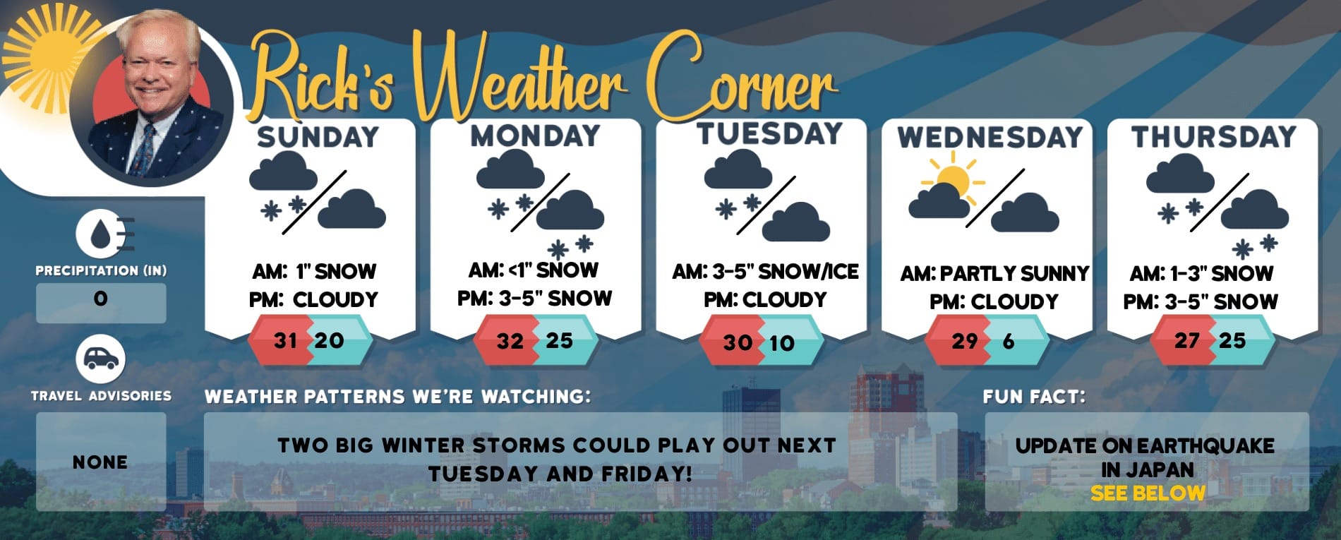
5-Day Outlook, Feb. 13-17
Today: Cloudy, windy, and colder with snow (3-5″). High 34 (feel like 21) Winds: N 10-20+ mphTonight: Becoming partly cloudy. Low 25 (feel like 17) Winds: NW 10-15 mphValentine’s Day: Sunny, windy, & cold. High 31 (feel like 20) Winds: NW 15–25+ mphWednesday night: Clear & breezy. Low 19 (feel like 5) Winds: NW 10-20 mphThursday: Breezy & cold with some sun & clouds. High 38 (feel like 32) Winds: WNW 10-15 mphThursday night: Cloudy with periods of snow (1-2″). Low 28 (feel like 19) Winds: S 5-15 mphFriday: Breezy with some sun & clouds. High 36 (feel like 29) Winds: WNW 10-20 mphFriday night: Some clouds. Low 21(feel like 16) Winds: WNW 10-15 mphSaturday: Cloudy with light snow or flurries. High 33 (feel like 23) Winds: WNW 10-15 mphSaturday night: Partly cloudy. Low 18 Winds W 5-10 mph
Weather Patterns We’re Watching
Next Monday for Presidents Day mostly sunny with highs in the low 40s.
Hiking Report/White Mountains Weather
Elevations for summits above 4,000 feet in Northern New Hampshire Today: Summits obscured. A chance of snow. Highs around 17. East winds around 20 mph increasing to north around 30 mph in the afternoon. Gusts up to 55 mph. The chance of snow is 50 percent. Wind chill values as low as 17 below.
Elevations between 2,500 and 4,000 feet in Northern New Hampshire Today: Summits obscured. A chance of snow. Highs in the lower 20s. Northeast winds around 10 mph increasing to north around 20 mph in the afternoon. Gusts up to 45 mph. The chance of snow is 50 percent. Highs in the lower 20s. Northwest winds 20 to 30 mph with gusts up to 55 mph. Wind chill values as low as 17 below.

Check for current conditions at Ski NH resorts here.