
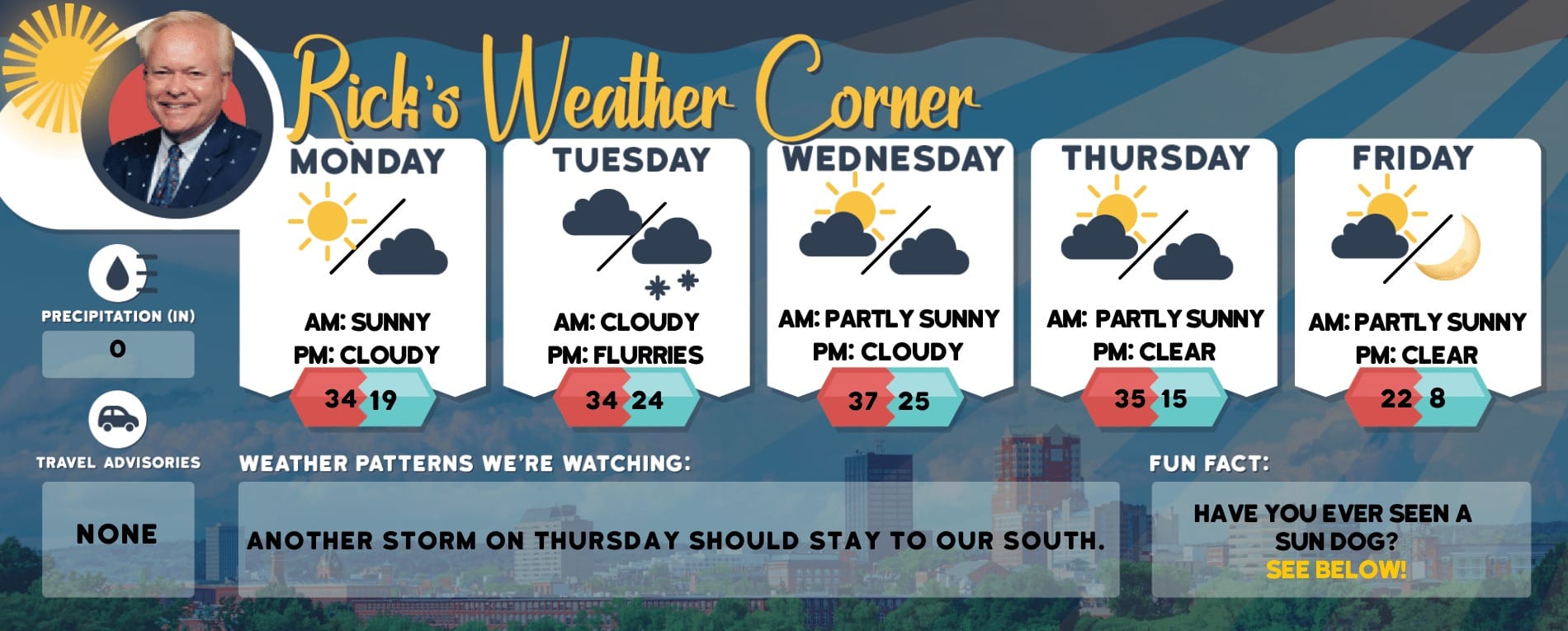
Thursday’s weather: Windy with wet snow, heavy at times, high of 38
Today is windy with wet snow of varying intensity. Temperatures are nearly steady in the mid to upper 30s. Winds NE at 25 to 35 mph. An additional 2-4 inches of snow is expected. Winds could occasionally gust to near 50 mph causing blizzard-like conditions, power outages, and dangerous travel.

Weather Watch with Rick Gordon
Below: Watch your weather outlook via YouTube, delivered in two minutes.
Thursday’s Weather
Today is windy with wet snow of varying intensity. Temperatures are nearly steady in the mid to upper 30s. Winds NE at 25 to 35 mph. An additional 2-4 inches of snow is expected. Winds could occasionally gust to near 50 mph causing blizzard-like conditions, power outages, and dangerous travel.
STORM WATCH

WINTER STORM WARNING IN EFFECT
WHAT: Heavy snow and sleet expected. Total snow accumulations up to 7 inches and sleet accumulations around 1 inch. Winds gusting as high as 55 mph.
WHERE: Coastal Rockingham, Eastern Hillsborough, and Interior Rockingham Counties.
WHEN: Now until 8 PM tonight.
IMPACTS: A nor’easter will bring plowable snow to the region with a period of moderate travel impacts expected. The combination of heavy wet snow and strong winds will lead to snapped branches and downed trees, resulting in power outages. Significant snowfall and periods of heavy snowfall rates will combine with low visibility to create very dangerous driving conditions. The hazardous conditions could impact the morning commute.
ADDITIONAL DETAILS: This is expected to be a long-duration, multi-faceted event. The wet snow in varying intensity will continue today when some of the heaviest rates may fall accompanied by strong, gusty winds. Be prepared for a prolonged duration of impact.
PRECAUTIONARY/PREPAREDNESS ACTIONS: Do not touch downed lines and report any power outages to your electric company. Travel is highly discouraged due to slick roadways and the possibility of downed trees and power lines.
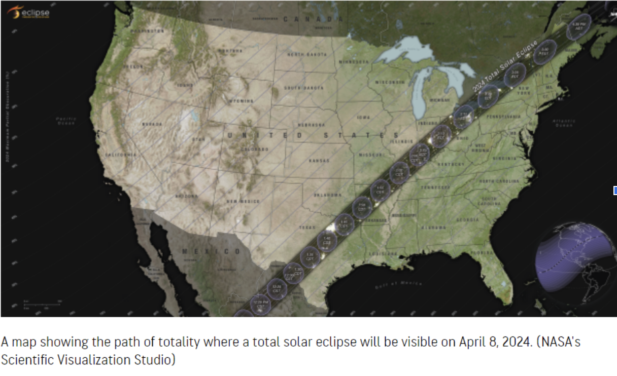
Solar Eclipse Weather Update Solar Eclipse Weather Outlook The final countdown is underway for the astronomy event of the decade – a total solar eclipse on Monday, April 8. The outlook is mostly sunny with a high of 62. We’ll keep you up to date on the forecast here. We’ll keep you up to date on the forecast here.
5-Day Outlook, April 4-April 8Today: Windy with wet snow heavy at times an additional 2-4″ with blizzard-like conditions. High 38 (feel like 27) Winds: NE 25-35+ (gust 50 mph)Tonight: Some snow (1″) to flurries late. Low 34 (feel like 27) Winds: NW 10-20 mphFriday: Cloudy with a few rain & snow showers. High 42 (feel like 35) Winds: NW 10-15 mphFriday night: Cloudy with some rain & snow showers. Low 34 Winds: NNW 5-10 mphSaturday: Chilly with a few rain or snow showers. High 43 (feel like 37) Winds: N 10-15 mphSaturday night: Some clearing late. Low 34 Winds: NNW 5-10 mphSunday: Warmer with a mix of sun & clouds. High 53 Winds: NNW 5-10 mphSunday night: Mainly clear. Low 35 Winds: Light & VariableMonday (Solar Eclipse): Warmer with mostly sunny sky and great viewing conditions. High 62 Winds: NW 5-10 mph Monday night: Mainly clear. Low 38 Winds: NW 5-10 mph
Solar Eclipse Weather Update
Solar Eclipse Weather Update Solar Eclipse Weather Outlook The final countdown is underway for the astronomy event of the decade – a total solar eclipse on Monday, April 8. The outlook is mostly sunny with a high of 62. We’ll keep you up to date on the forecast here. We’ll keep you up to date on the forecast here.
Weather Patterns We’re WatchingWarmer next week with temperatures in the 60s, could reach 70 by week’s end.

Hiking Report/White Mountains Weather
Elevations for summits above 4,000 feet in Northern New Hampshire Today: Snow total of 1-2 feet. Highs in the lower 20s… except 11 to 21 at elevations above 5000 feet. East winds 45 to 55 mph with gusts up to 85 mph. The chance of snow is near 100 percent. Wind chill values are as low as 21 below.
Elevations between 2,500 and 4,000 feet in Northern New Hampshire Today: Snow total of 1-2 feet. Highs in the mid-20s. East winds 30 to 40 mph with gusts up to 75 mph. The chance of snow is near 100 percent. Wind chill values as low as 8 below.

Click here to check out the current conditions at NH Ski Resorts!