
Thursday’s weather: Partly sunny, windy, high of 40
Expect strong winds and colder temperatures today, accompanied by a mix of sun and clouds. The high will reach 40° but feel more like 28°. Winds will come from the WNW at 20-30 mph, with gusts exceeding 40 mph. Stay prepared for blustery conditions!

Rick Gordon’s Weather Watch
Follow our YouTube channel here.
Today’s Weather Outlook
Expect strong winds and colder temperatures today, accompanied by a mix of sun and clouds. The high will reach 40° but feel more like 28°. Winds will come from the WNW at 20-30 mph, with gusts exceeding 40 mph. Stay prepared for blustery conditions!
5-Day Outlook
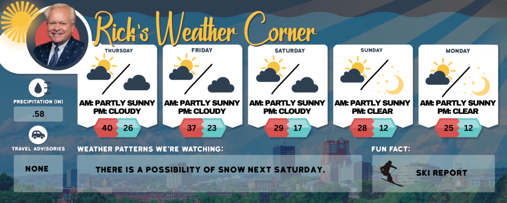
Today: Strong winds & colder with sun & clouds. High 40 (feel like 28) Winds: WNW 20-30+ with gusts over 40 mph
Tonight: Partly cloudy & windy. Low 26 (feel like 14) Winds: W 15-20+ mph
Friday: Windy with some sun & clouds. High 37 (feel like 25) Winds: W 15-20+ with gusts over 30 mph
Friday night: Partly cloudy & cold. Low 23 (feel like 15) Winds: W 5-15+ mph
Saturday: Some sun and breezy. High 29 (feel like 17) Winds: WNW 15-20 mph
Saturday night: Partly cloudy, breezy, & cold. Low 17 (feel like 7) Winds: NW 10-15 mph
Sunday: Cold breeze with sun & clouds. High 28 (feel like 14) Winds: WNW 10-20 mph
Sunday night: Mainly clear, breezy, & frigid. Low 12 (feel like 0) Winds: NW 10-15+ mph
Monday: Breezy with Intervals of clouds and sunshine. High around 25 (feel like 13) Winds: NW 10-15 mph
Monday night: Mainly clear & breezy. Low 12 (feel like 0) Winds: NW 10-15 mph
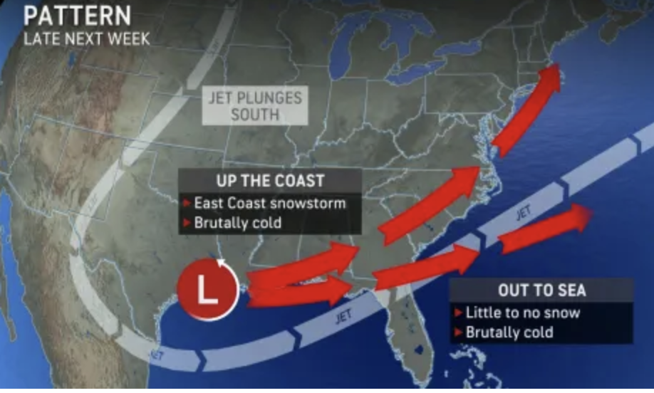
Arctic Express Next Week
Arctic Express Next Week!!!! The first weekend of 2025 will be exceptionally cold, with low temperatures in the teens and highs reaching only around 30 degrees. The first full week of January high temperatures staying below freezing with lows in the teens. The potential for some snow late next week! Here are the two scenarios for the snow late next week.
Weather Patterns We’re Watching
There is a possibility of snow next Saturday.
Skiing and Snowboarding Weather Report.
Elevations for summits above 4,000 feet in Northern New Hampshire today: Summits will be obscured. Snow is likely in the morning, followed by snow showers in the afternoon. Highs will be around 18 degrees. West winds will range from 45 to 55 mph, except for west winds of 55 to 75 mph at elevations above 5000 feet. There is a 70 percent chance of snow. Wind chill values could be as low as 27 degrees below zero.
Elevations between 2,500 and 4,000 feet in Northern New Hampshire today: Summits will experience intermittent cloud cover. Snow is likely in the morning, followed by snow showers in the afternoon. High temperatures will be in the lower 20s. winds will range from30 to 40 mph, with gusts up to 90 mph. The chance of snow is 70 percent. Wind chill values may drop as low as 13 below zero