
Thursday’s weather: Mild with periods of rain with flood watch in effect, a high of 50
Today is mild with periods of rain (.70″) with a high of 52; there can be ponding on roadways.

Weather Watch with Rick Gordon
Below: Watch your weather outlook via YouTube, delivered in two minutes.
WEATHER ALERT
WHAT: Flooding caused by rain and snowmelt is possible.WHERE: Coastal Rockingham, Eastern Hillsborough, Interior Rockingham, Merrimack, Strafford, and Western and Central Hillsborough.WHEN: From Thursday morning through Friday afternoon.IMPACTS: Small streams may rise out of their banks. Flooding may occur in poor drainage and urban areas.ADDITIONAL DETAILS: Rainfall up to 2 inches will combine with over an inch of snowmelt runoff to cause urban, low-lying, and small-stream flooding.PRECAUTIONARY/PREPAREDNESS ACTIONS: You should monitor the latest forecast and be alert for possible Flood Warnings.
Thursday’s Weather
Today is mild with periods of rain (.70″) with a high of 52; there can be ponding on roadways.
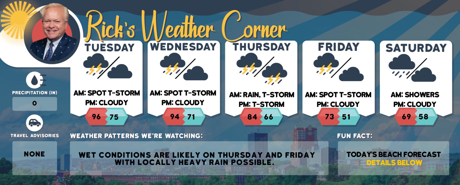
5-Day Outlook, March 28-April 1Today: Periods of rain (.70″) and mild. High 50 Winds: NW 5-10 mphTonight: Periods of rain (.50″) & breezy. Low 39 (feel like 29) Winds: NNW 10-15 mphFriday: Mostly cloudy with some morning showers and windy. High 50 (feel like 41) Winds: NW 20-25+ mphFriday night: Mostly clear & windy. Low 36 (feel like 23) Winds: NW 20-25+ mphSaturday: Sunny with strong gusty winds. High 50 (feel like 42) Winds: 20-30+ mph Saturday night: Clear to partly cloudy. Low 35 (feel like 30) Winds: NW 10-15 mphEaster: Breezy with some sun & clouds. High 51 (feel like 46) Winds: NW 10-20 mphSunday night: Mainly clear. Low 32 Winds: NW 5-10 mphMonday: Some sun & clouds. High 55 Winds: SSW 5-10 mphMonday night: Becoming cloudy with some rain late. Low 36 Winds: SE 5-10 mph
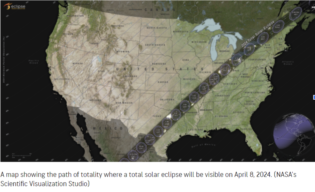
Solar Eclipse Weather Outlook
The final countdown is underway for the astronomy event of the decade – a total solar eclipse on Monday, April 8. The outlook is cloudy with some rain and a high of around 60. We’ll keep you up to date on the forecast here. We’ll keep you up to date on the forecast here.
Weather Patterns We’re WatchingThe outlook for Easter Sunday is some sun & clouds with a high of 51.

Hiking Report/White Mountains Weather
A backcountry Avalanche Warning is in effect.
Elevations for summits above 4,000 feet in Northern New Hampshire Today: Summits obscured. Rain likely. Highs in the upper 30s. West winds 10 to 15 mph with gusts up to 30 mph. Chance of rain 60 percent.
Elevations between 2,500 and 4,000 feet in Northern New Hampshire Today: Summits obscured. Rain likely. Highs in the lower 40s. Northwest winds up to 10 mph with gusts up to 25 mph. Chance of rain 70 percent.

Click here to check out the current conditions at NH Ski Resorts!