
Thursday’s weather: Freezing rain turns to rain, high in the low to mid-30s
Freezing rain is expected in the morning, transitioning to rain later. Some icing is possible. Temperatures will remain steady in the low to mid-30s (feeling like 29). Winds will be from the northwest at 10-15 mph.


Rick Gordon’s Weather Watch
Follow our YouTube channel here.
Today’s weather
Freezing rain is expected in the morning, transitioning to rain later. Some icing is possible. Temperatures will remain steady in the low to mid-30s (feeling like 29). Winds will be from the northwest at 10-15 mph.
5-Day Outlook
Today: Freezing rain in the morning…mixing with rain later. Some icing possible. Temperatures nearly steady in the low to mid 30s (feel like 29) Winds: NW 10-15 mph
Tonight: Partly cloudy, cold, & breezy. Low 18 (feel like 9) Winds: WNW 10-20 mph
Friday: Mostly sunny, windy (gusts near 40 mph), & colder. High 27 (feel like 14) Winds: NW 15-25+ mph
Friday night: Partly cloudy to mostly cloudy & cold. Low 9 Winds: WNW 5-10 mph
Saturday: Cloudy with snow showers developing in the afternoon. High 29 Winds: Light & Variable
Saturday night: Watching a potential winter storm. Periods of snow (3-5″) Low 22 Winds: E 5-10 mph
Sunday: Watching a potential winter storm. Snow & an icy mix during the morning (3-5″) will become freezing rain during the afternoon. High 32 (fee like 21) Winds: NE 10-20 mph
Sunday night: Snow (1″) in the evening will give way to some clearing overnight. Low 18 (feel like 5) Winds: NW 10-15+ mph
Presidents Day: Frigid gusty wind that could gust over 40 mph with clouds & sun. High 23 (feel like 7) Winds: WNW 20-30+ mph
Monday night: Becoming clear, windy, frigid. Low 3 (feel like -11) Winds: WNW 15-25+ mph
Weather Alert
Another winter storm this weekend with a snowstorm turning into an ice storm on Sunday! The weekend will begin as a snowstorm on Saturday night 3-5 inches of snow expected. It will then transition into a wintry mix on Sunday morning with an additional 3-5 inches of snow and ice anticipated. The precipitation will mostly turn into freezing rain in the afternoon. Please check back frequently for updates.
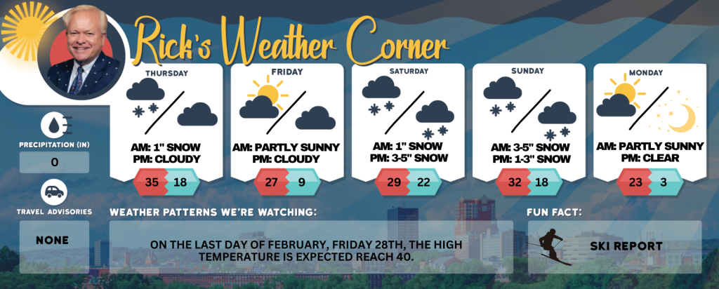
Weather Patterns We’re Watching
On the last day of February, Friday 28th, the high temperature is expected reach 40.
Skiing and Snowboarding Weather Report
Elevations for summits above 4,000 feet in New Hampshire today: Summits obscured. Snow, freezing rain and sleet. Highs in the mid 20s. Southeast winds around 40 mph in the morning. Winds southwest in the afternoon. At elevations above 5000 feet, southeast winds around 55 mph in the morning. Gusts up to 80 mph. Chance of precipitation 90 percent. Wind chill values as low as 22 below.
Elevations between 2,500 and 4,000 feet in Northern New Hampshire today: Snow and sleet. Freezing rain likely. Highs in the upper 20s. South winds 20 to 30 mph with gusts up to 65 mph. Chance of precipitation near 100 percent. Wind chill values as low as 18 below.


