
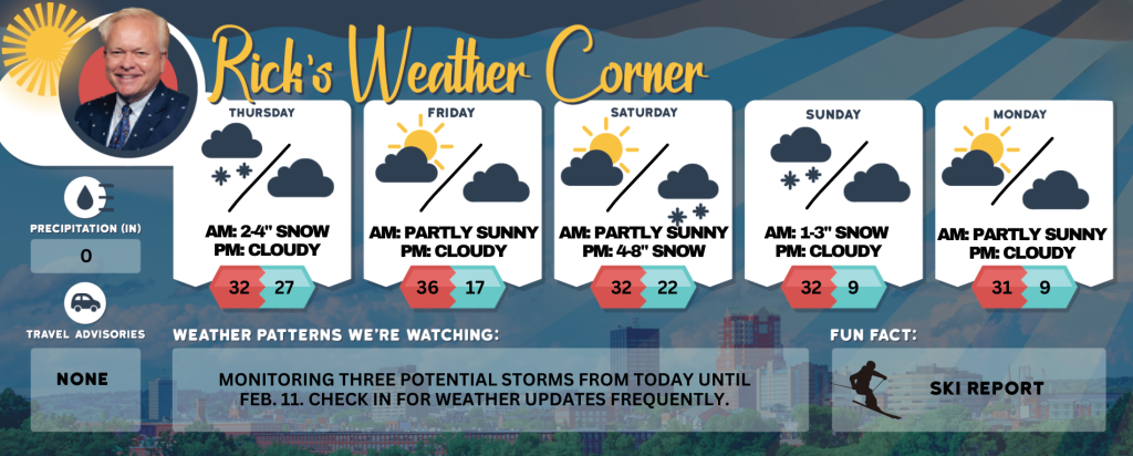
Thursday’s weather: Expect 2-4 inches of snow turning to wintry mix, high of 32
Snow expected to mix with sleet and freezing rain late this afternoon. Total snow accumulations between 2 and 4 inches and ice accumulations around a light glaze.


Rick Gordon’s Weather Watch
Follow our YouTube channel here.
Today’s Weather
We’re gearing up for a classic New England winter day! Make sure to bundle up and drive safely out there. Here’s a quick summary of what to expect: Snowfall: 2-4 inches transitioning to a wintry mix this afternoon. Temperature: High of 32° Winds: ESE at 5-10 mph. Travel: Expect slow and hazardous conditions due to rapidly deteriorating roads. Perfect weather to cozy up with a warm drink, don’t you think? If you need more details, check out Manchester INKLINK for up-to-date information. Stay safe! ❄️🥶🚗
WINTER WEATHER WATCH

WHAT: Snow expected to mix with sleet and freezing rain late this afternoon. Total snow accumulations between 2 and 4 inches and ice accumulations around a light glaze.
IMPACTS: Plan on slippery road conditions. The hazardous conditions could impact the evening commute.
PRECAUTIONARY/PREPAREDNESS ACTIONS: Slow down and use caution while traveling. The latest road conditions can be obtained by going to newengland511.org
5-Day Outlook
Today: Some snow (2-4 inches) transitioning to a wintry mix late this afternoon. High 32 Winds: ESE 5-10 mph
Tonight: Cloudy to partly cloudy. Low 27 Winds: WSW 5-10 mph
Friday: Gusty winds could occasionally gust over 40 mph with some clouds & sun. High 36 (feel like 21) Winds: WNW 15-25+ mph
Friday night: Partly cloudy & colder. Low 17 Winds: WNW 5-10 mph
Saturday: Some morning sun followed by clouds. High 32 Winds: WNW 5-10 mph
Saturday night: Snow (4-8″). Low 22 Winds: Light & Variable
Sunday: Early morning snow (1-3″) with some afternoon sun & windy. High 33 (feel like 25) Winds: NW 10-20 mph
Sunday night: Clear & very cold. Low 9 (feel like 1) Winds: NW 10-15 mph
Monday: Sunny & cold. High 31 Winds: WNW 5-10 mph
Monday night: Clouding up & very cold. Low 9 Winds: Light & Variable
Weather Patterns We’re Watching
Monitoring three potential storms from today until Feb. 11. Check in for weather updates frequently.
Skiing and Snowboarding Weather Report
Elevations for summits above 4,000 feet in New Hampshire today: Snow accumulation of 5 inches is expected. High temperatures will be in the lower 20s. South winds will range 25 to 35 mph, with gusts up to 60 mph. There is a near 100 percent of snow. Wind chill values could be as low as 21 degrees below zero.
Elevations between 2,500 and 4,000 feet in Northern New Hampshire today: A chance of snow in the morning, followed by snow accumulation of 5 inches in the afternoon. High temperatures will be in the lower 20s. South winds will range from 10 to 20 mph, gust reaching up to 50 mph. The probability of snow is near 100 percent.


