
Thursday’s weather: Cloudy, windy, light snow turning to rain, high of 44
Today’s weather is expected to be cloudy and windy, with light snow in the early morning transitioning to rain. The high temperature will reach 44°, but it may feel as cool as 34° due to winds from the south at 15 to 20 mph, with gusts potentially exceeding 20 mph.

Rick Gordon’s Weather Watch
Follow our YouTube channel here.
Today’s weather
Today’s weather is expected to be cloudy and windy, with light snow in the early morning transitioning to rain. The high temperature will reach 44°, but it may feel as cool as 34° due to winds from the south at 15 to 20 mph, with gusts potentially exceeding 20 mph.
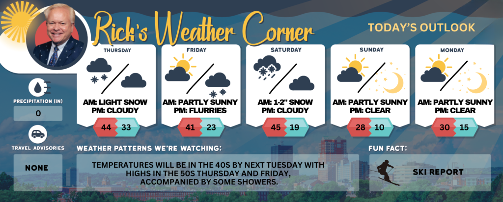
5-Day Outlook
Today: Cloudy & windy with early morning light snow to rain. High 44 (feel like 34) Winds: S 15-20+ mph
Tonight: Becoming partly cloudy & mild. Low 33 Winds: WSW 5-10 mph
Friday: Windy with some clouds & sun. High 41 (feel like 32) Winds: WNW 15-25+ mph
Friday night: Colder & breezy with light snow (1-2″) after midnight. Low 23 (feel like 18) Winds: Light & Variable
Saturday (March 1st): Cloudy with some rain & snow showers. High 45 (feel like 40) Winds: SSW 5-15 mph
Saturday night: Some clouds & cold. Low 19 (feel like 14) Winds: WNW 10-15 mph
Sunday: Cold & windy with some sun & clouds. High 28 (feel like 15) Winds: NW 10-20+ mph
Sunday night: Clear, breezy, & very cold. Low 10 (feel like -3) Winds: NW 10-15 mph
Monday: Mostly sunny, breezy, and cold. High 30 (feel like 19) Winds: NW 10-15 mph
Monday night: Clear to partly cloudy. Low 15 Winds: W 5-10 mph
Weather Alerts
March arrives like a lion on Saturday, marking the beginning of meteorological spring with another Alberta clipper system producing some rain & snow showers. Sunday will bring some sunshine and cold temperatures, with a gusty wind making the 28 degrees like 15.
Weather Patterns We’re Watching
Temperatures will be in the 40s by next Tuesday with highs in the 50s Thursday and Friday, accompanied by some showers.
Skiing and Snowboarding Weather Report
Elevations for summits above 4,000 feet in New Hampshire today: Heads up for those venturing outdoors! Expect the mountains to be shrouded in clouds and blanketed with 2 to 4 inches of fresh snow. High temperatures will only reach the lower 30s, so bundle up! South winds are picking up, gusting between 20 to 30 mph, with some fierce gusts hitting up to 60 mph. There’s an 80 percent chance of snow, which means it’s a great day for winter activities—just be prepared for wind chill values that could drop as low as 5 degrees above zero. Stay warm and enjoy the winter wonderland!
Elevations between 2,500 and 4,000 feet in Northern New Hampshire today: The mountain peaks will be hidden today. Expect 2 to 4 inches of snow, with rain likely arriving in the afternoon. Temperatures will be in the low 30s. There will be a south wind blowing at 10 to 15 miles per hour, with some gusts reaching up to 45 miles per hour. There’s an 80 percent chance of precipitation, so be prepared for wet weather!