
Thursday’s weather: Cloudy, breezy, high of 57, afternoon showers
Expect a mostly cloudy and breezy day with mild temperatures, reaching a high of 57 degrees but feeling like 51. An afternoon shower may roll in, so be prepared! Winds will be brisk, coming from the south-southwest at 15-25 mph. Stay alert and enjoy the day!


Rick Gordon’s Weather Watch
Follow our YouTube channel here.Rick Gordon’s Weather Watch
Follow our YouTube channel here.
Today’s Weather
Expect a mostly cloudy and breezy day with mild temperatures, reaching a high of 57 degrees but feeling like 51. An afternoon shower may roll in, so be prepared! Winds will be brisk, coming from the south-southwest at 15-25 mph. Stay alert and enjoy the day!
Weather Alerts
Following a cold and windy weekend with highs in the upper 30 s, a significant warm-up is expected next week.
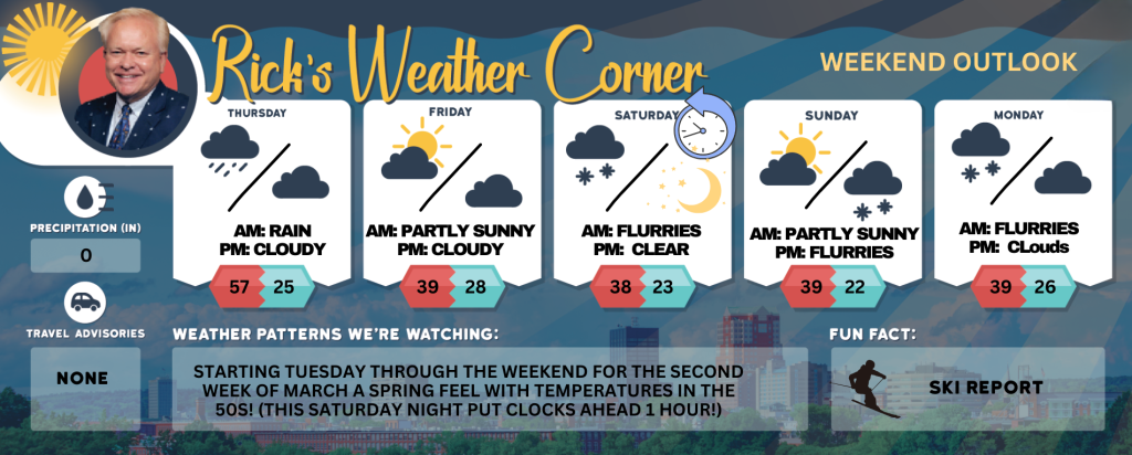
5-Day Outlook
Today: Mostly cloudy, breezy and mild with an afternoon shower in spots. High 57 (feel like 51) Winds: SSW 15-25+
Tonight: Some clouds, colder, and windy. Low 25 (feel like 10) Winds: WNW 15-25+ (some gusts over 40 mph)
Friday: Very windy with some sun & clouds. High 39 (feel like 27) Winds: WNW 25-35+ (gusts over 40 mph possible)
Friday night: Partly cloudy & breezy. Low 28 (feel like 18) Winds: W 10-20 mph
Saturday: Gusty winds with some afternoon sun & clouds. High 38 (feel like 30) Winds: WNW 15-25+ (gusts over 40 mph possible)
Saturday night (Put clocks ahead 1 hour before you go to bed.): Partly cloudy & cold. Low 23 (feel like 12) Winds: WNW 10-20+ mph
Sunday: Some sun & clouds with a cold wind. High 39 (feel like 31) Winds: WNW 10-15+ mph
Sunday night: A few flurries or snow showers possible. Low 22 (feel like 17) Winds: WNW 5-15 mph
Monday: A few flurries or snow showers possible during the morning with some afternoon sunshine. High 39 (feel like 30) Winds: W 10-15 mph
Monday night: Some clouds. Low 26 (feel like 23) Winds: W 5-15 mph
Weather Patterns We’re Watching
Starting next Tuesday through the weekend for the second week of March a spring feel with temperatures in the 50s! (This Saturday night put clocks ahead 1 hour!)
Skiing and Snowboarding Weather Report
Elevations for summits above 4,000 feet in New Hampshire today: The summits are obscured, and rain is likely in the morning, with a chance of rain continuing into the afternoon. High temperatures will be around 40°F. Southwest winds will be around 30 mph, decreasing to about 20 mph later in the afternoon, with gusts reaching up to 60 mph. There is a 70 percent chance of rain, and wind chill values could feel as low as 10°F above zero.
Elevations between 2,500 and 4,000 feet in Northern New Hampshire today: Summits will be obscured in the morning, followed by periods of summits in and out of clouds. There is a chance of rain with highs in the lower40s. Southwest winds will range from 10 to 20 mph, with gusts up to 45 mph. The chance of rain is 50 percent


