
Thursday’s weather: Cloudy and muggy, high of 85
Anticipate a cloudy and muggy day with scattered afternoon showers and a possible thunderstorm; these storms may lead to flooding downpours and localized damaging wind gusts. The high will be around 85, but it will feel more like 87.


Weather Watch with Rick Gordon
Click below for Rick’s exclusive videocast
Thursday’s Weather
Anticipate a cloudy and muggy day with scattered afternoon showers and a possible thunderstorm; these storms may lead to flooding downpours and localized damaging wind gusts. The high will be around 85, but it will feel more like 87.
5-Day Forecast July 25-July 29
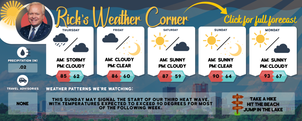
Today: Expect a cloudy and humid day with spot afternoon showers and a thunderstorm; storms can bring flooding downpours and localized damaging wind gusts. High 85 (feel like 87) Winds: SW 10-15 mph
Tonight: Partly cloudy and turning less humid. Low 62 Wins: WNW 5-10 mph
Friday: Mostly sunny, breezy, and comfortable. High 86 Winds: NW 10-15mph
Friday night: Mainly clear. Low 60 Winds: NW 5-10 mph
Saturday: Mostly sunny & nice. High 87 Winds: Light & Variable
Saturday night: Partly cloudy. Low 59 Winds: Light & Variable
Sunday: Mostly sunny, hot, and turning more humid. High 90 (feel like 95) Winds: Light & Variable
Sunday night: Mainly clear and humid. Low 64 Winds: Light & Variable
Monday: Some sun, hot, and humid. High 93 (feel like 95) Winds: SSW 5-10 mph
Monday night: Some clouds & humid. Low 67 Winds: S 5-10 mph
Weather Patterns We’re Watching
This Sunday may signal the start of our third heat wave, with temperatures expected to exceed 90 degrees for most of the following week.
Hiking/Beach/Lake Forecasts
Take a Hike
Elevations for summits above 4,000 feet in Northern New Hampshire Today: Summits will be obscured. There’s a chance of showers in the morning, followed by likely showers and scattered thunderstorms in the afternoon. Expect highs in the mid-60s, except in the upper 50s at elevations above 5000 feet. Westerly winds will range from 15 to 25 mph, with gusts up to 50 mph. The chance of rain is 70 percent.
Elevations between 2,500 and 4,000 feet in Northern New Hampshire Today: Summits in and out of clouds. A chance of showers in the morning then showers likely with scattered thunderstorms in the afternoon. Highs in the upper 60s. Southwest winds 10 to 15 mph with
gusts up to 40 mph. Chance of rain 70 percent.
Hit the Beach
- Weather: Mostly cloudy. Widespread dense fog is expected. Scattered thunderstorms and a possibility of showers are also forecasted.
- UV Index: Low
- Thunderstorm Potential: Moderate. Implies that thunderstorms are possible.
- High Temperature: In the upper 70s.
- Winds: South winds around 5 mph.
- Water Temperature: 61 degrees.
- Surf Height: Around 2 feet.
- Tides Hampton Beach: Low tide at -0.9 feet (MLLW) will occur at 09:14 AM, followed by a high tide of 9.3 feet (MLLW) at 03:14 PM.
Jump in a Lake
South winds will be around 5 mph, becoming southwest in the afternoon. Expect waves about 1 foot high. Morning fog is likely, followed by mostly cloudy skies with a chance of showers. Scattered thunderstorms may occur in the afternoon. It will be humid with high temperatures in the upper 70s. The chance of rain is 50 percent. There is a moderate lightning threat, indicating possible thunderstorms. The water temperature will be 74 degrees.


