Sunday’s weather: Partly sunny and breezy, possible showers, high of 73
Today clouds giving way to some sunshine. Expect periods of rain in the morning and a thundershower in some areas during the afternoon with a high of 73.
Today clouds giving way to some sunshine. Expect periods of rain in the morning and a thundershower in some areas during the afternoon with a high of 73.
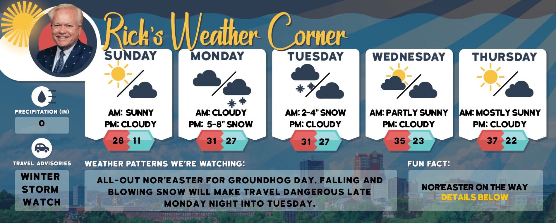
5-Day Outlook, June 9-13
Today: The day will be breezy with clouds giving way to some sunshine. Expect periods of rain in the morning and a thundershower in some areas during the afternoon. High 73 Winds: WSW 10-15 mph
Tonight: Partly cloudy. Low 56 Winds: W 5-10 mph
Monday: Some sun & clouds with a passing afternoon shower. High 77 Winds: W 5-10 mph
Thursday: Some sun and very warm. High 88 Winds: SW 5-10 mph
Thursday night: Some clouds, mild, and more humid. Low 65 Winds: SW 5-10 mph
Weather Patterns We’re WatchingMidway through the next week, temperatures are expected to be above average, with highs in the mid-80s and it could hit 90 degrees next Saturday.
Hiking/Beach/Lake Forecasts
Take a HikeElevations for summits above 4,000 feet in Northern New Hampshire Today: The summits will be obscured with showers expected. Temperatures will reach highs in the lower 50s. Westerly winds will blow at about 30 mph, decreasing to around 20 mph in the afternoon. Wind gusts may reach up to 50 mph. There is an 80 percent chance of rain.Elevations between 2,500 and 4,000 feet in Northern New Hampshire Today: Summits obscured. Rain is likely in the morning, then showers in the afternoon. Highs in the mid-50s. West winds 10 to 15 mph with gusts up to 35 mph. Chance of rain 90 percent.
Hit the BeachWeather: Clouds breaking for some sun, breezy and cooler; periods of rain in the morning followed by a stray thundershower in parts of the area in the afternoonThunderstorm Potential: Slight.High Temperature: In the upper 60s.UV Index: Moderate.Winds: Southwest winds around 10 mph.Water Temperature: 60 degrees.Surf Height: Around 2 feet.Rip Current Risk: LowTides Hampton Beach: Low -0.4 feet (MLLW) 08:29 AM. High 8.2 feet (MLLW) 02:27 PM.
Jump in a LakeWesterly winds will be approximately 10 mph, with gusts reaching up to 20 mph. Expect wave heights of around 2 feet. The morning may bring patchy fog, followed by rain. Temperatures will reach the upper 60s. There is a 90 percent chance of rain. The moderate lightning threat indicates the possibility of thunderstorms. The water temperature will be 68 degrees.