
Sunday’s weather: Breezy, balmy and rainy, high of 60
Winds howl tonight into early tomorrow morning with powerful gusts ranging from 40-45 mph with gusts near 60 mph along the coast of New Hampshire. At this strength, tree damage can occur, which can block some roads, trigger power outages, and cause property damage along with coastal flooding. Not on

Weather Watch with Rick Gordon
Below: Watch your weather outlook via YouTube, delivered in two minutes.
Sunday’s WeatherWinds howl tonight into early tomorrow morning with powerful gusts ranging from 40-45 mph with gusts near 60 mph along the coast of New Hampshire. At this strength, tree damage can occur, which can block some roads, trigger power outages, and cause property damage along with coastal flooding. Not only the wind but rain will be heavy (1-3″) which can cause flooding on streets and highways along with reduced visibility.
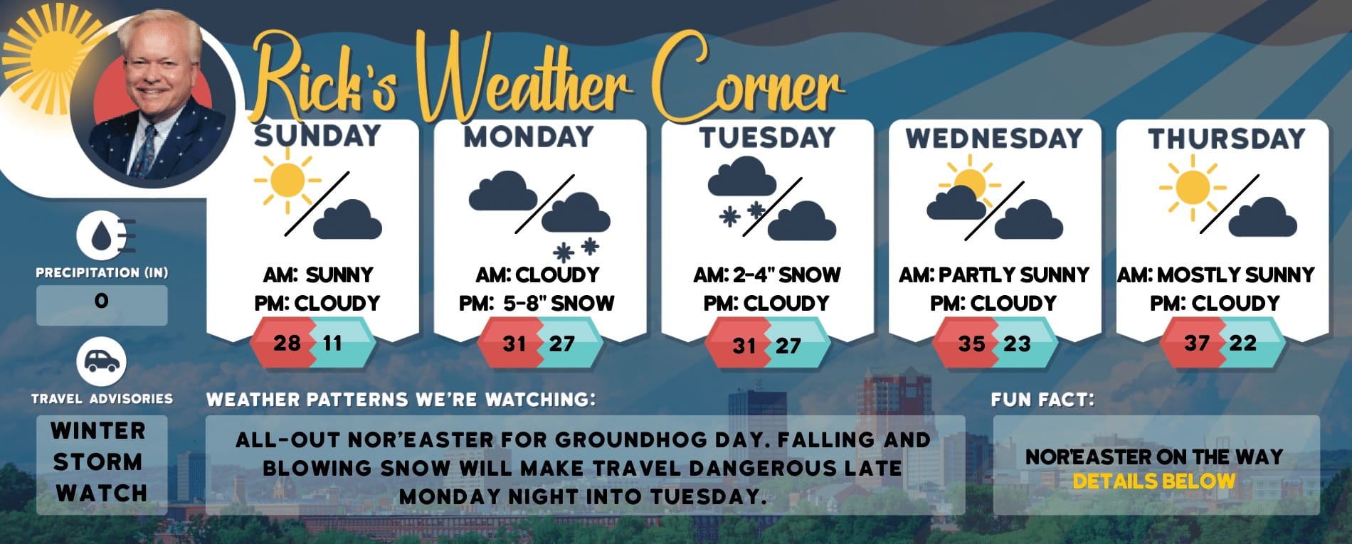
5-Day Outlook, Dec. 9 – 13Today: Breezy, balmy & mild with showers to rain (.20″). High 60 Winds: S 10-15+ mphTonight: Very windy with gusts over 40 mph & mild with heavy rain (1-2″). Low 42 Winds: SSE 20-30+ mphMonday: Morning rain (.50) with afternoon sun & windy with gusts to 40 mph. High 44 with temperatures falling into the 30s Winds: WNW 15-25+ mphMonday night: Clear, breezy, & colder. Low 26 (feel like 17) Winds: W 10-15+ mphTuesday: Mostly sunny. High 42 Winds: WSW 5-10 mphTuesday night: Clear to partly cloudy. Low 30 Winds: SW 5-10 mphWednesday: Cold with a mix of sun & clouds. High 39 (feel like 31) Winds: W 10-15 mphWednesday night: Some clouds. Low 26 Winds: W 5-10 mphThursday: Some sun & clouds. High 40 Winds: W 5-10 mphThursday night: Mainly clear. Low 28 Winds: WSW 5-10 mph
Weather Alert
WHAT: Caused by rain and snowmelt remains possible. Heavy rainfall of 1 to 3 inches with isolated amounts of up to 4 inches is possible across New Hampshire.WHERE: New Hampshire WHEN: From Sunday afternoon through Monday evening.IMPACTS: Creeks and streams may rise out of their banks.ADDITIONAL DETAILS: Heavy rainfall along with warm temperatures will cause melting of the snowpack from the foothills southward. This will increase the runoff into streams and rivers. Moderate to heavy rainfall over partially frozen ground will support the potential for flash flooding as well as river flooding. Disruptions to travel are likely on Monday. PRECAUTIONARY/PREPAREDNESS ACTIONS. You should monitor the latest forecast on ManchesterInkLink and be alert for possible Flood Warnings. Those living in areas prone to flooding should be prepared to take action should flooding develop.
Weather Patterns We’re Watching
Next Tuesday through the weekend will be storm-free with temperatures warming into the 40s.

Hiking Report/White Mountains Weather
Elevations for summits above 4,000 feet in Northern New Hampshire Today: Summits obscured. A chance of rain in the morning, then rain in the afternoon. Highs in the lower 40s. Southwest winds 25 to 35 mph with gusts up to 65 mph. Chance of rain 90 percent.
Elevations between 2,500 and 4,000 feet in Northern New Hampshire Today: Summits obscured. A chance of rain in the morning, then rain in the afternoon. Highs in the lower 40s. Southwest winds 10 to 20 mph with gusts up to 55 mph. Chance of rain 90 percent.
NH Ski Season 2023

Check for opening dates for Ski NH resorts.