
Sunday’s weather: 5-8-inches more of snow, windy, with a high of 30
Winter storm warning through this evening. Snow with an additional 5″ for Manchester and 8″ for coast & windy with blowing snow & drifting. High 30 but feels like 20.

Weather Watch with Rick Gordon
Below: Watch your weather outlook via YouTube, delivered in two minutes.
Sunday’s WeatherWinter storm warning through this evening. Snow with an additional 5″ for Manchester and 8″ for coast & windy with blowing snow & drifting. High 30 but feels like 20.
Weather Alerts
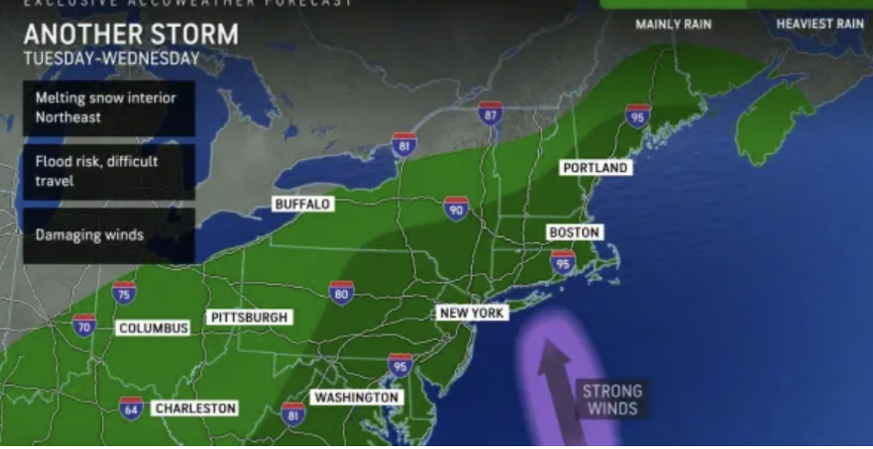
Rain Tuesday night into Wednesday will likely bring a rapid melting of the existing snow cover on the ground beneath that is still wet from prior storms in December. Flooding of city streets, small streams, and even along some major rivers is likely. In addition to the likelihood of heavy rain and flooding is the risk of damaging winds and power outages with winds gusting over 40 mph. Property owners and road crews may be able to help with flood control by keeping storm drains free from piles of snow during storm cleanup operations.
Winter Storm WarningThe National Weather Service has upgraded the Winter Storm Watch to a Winter Storm Warning from Saturday evening through 1 a.m. on Monday.WHAT…Heavy snow is expected. Total snow accumulations of 6 to 12 inches. Winds gusting as high as 35 mph.WHERE…Central and southern New Hampshire.WHEN...From Saturday evening to 1 a.m. Monday.IMPACTS…Travel could be very difficult with blowing snow.ADDITIONAL DETAILS...Snow overspreads the region from west to east roughly between 7 and 9 p.m. Saturday The snow will then become heavy and fall at 1 to 2 inches per hour for a time Saturday night into Sunday morning. Snow will continue Sunday and should finally come to an end sometime early Sunday evening.PRECAUTIONARY/PREPAREDNESS ACTIONS… If you must travel, keep an extra flashlight, food, and water in your vehicle in case of an emergency.
5-Day Outlook, Jan. 7-11

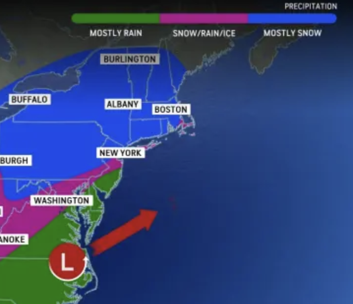
Today: Winter storm warning through this evening. Snow with an additional 5-8″ & windy with blowing snow. High 30 (feel like 20) Winds: NNE 10-20+ mphTonight: Evening flurries with some clearing late. Low 19 Winds: NNW 5-15 mphMonday: Mostly sunny & breezy. High 36 (feeling like 26) Winds: NW 10-15 mphMonday Night: Clear to partly cloudy. Low 16 Winds: NW 5-10 mphTuesday: Partly to mostly cloudy. High 35 Winds: NE 5-10 mphTuesday night: Windy with rain & snow to a heavy rain (1″). Low 32 Winds: ESE 15-20+ mphWednesday: Morning rain (.50″); mostly cloudy, mild, and windy. High 54 Winds: S 15-25+ mphWednesday night: Partial clearing & breezy. Low 34 (feel like 29) Winds: WSW 10-15 mphThursday: Some sun & clouds. High 44 (feel like 37) Winds: WSW 10-15 mphThursday night: Clearing. Low 30 Winds: W 5-10 mph
Weather Patterns We’re Watching
Our next storm Tuesday night into Wednesday will bring heavy rain, strong wind, and flooding. On the coast coastal flooding and beach erosion with power outages.

Hiking Report/White Mountains Weather
Elevations for summits above 4,000 feet in Northern New Hampshire Today: Summits obscured. Snow (2-4″). Highs around 13. East winds 10 to 20 mph with gusts up to 35 mph. The chance of snow is 90 percent.
Elevations between 2,500 and 4,000 feet in Northern New Hampshire Today: Summits obscured. Snow (2-4″). Highs around 15. East winds 10 to 15 mph with gusts up to 30 mph. The chance of snow 90 percent.

Check for opening dates for Ski NH resorts.