
Storm update: Overnight snow, heavy at times, 3-5 inches with another inch Sunday
Snow, becoming heavy at times. Accumulation: 3-5 inches. Expect rapidly deteriorating road conditions, slow and slippery travel.


Rick Gordon’s Weather Watch
Follow our YouTube channel here.
Weekend Weather Wrap
Here’s a summary of Super Bowl weekend. Looks like it’s going to be a wintery weekend! Stay prepared, and make sure to keep that shovel and winter gear handy. Perhaps this would be a good weekend to catch up on indoor activities or enjoy some hot cocoa and the Super Bowl. ☕️❄️ If you need an updated forecast, checking back here might be a good idea. Stay warm and safe!
Saturday night: Snow, becoming heavy at times. Accumulation: 3-5 inches. Expect rapidly deteriorating road conditions, slow and slippery travel.
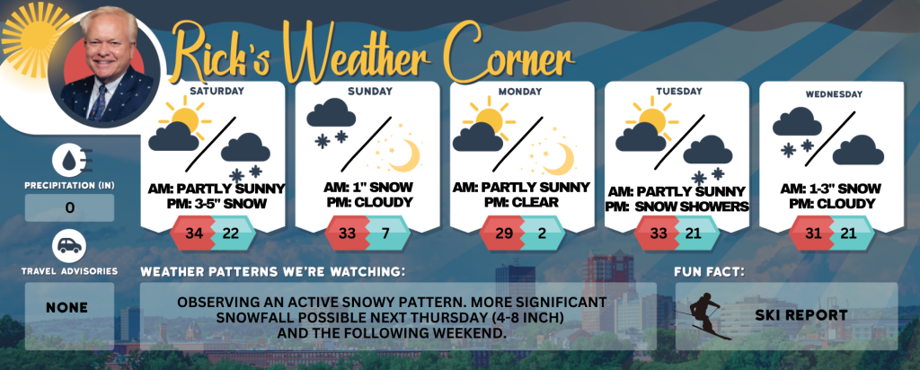
Sunday: Early morning snow, up to 1 inch. Storm Total: 4-6 inches. Some sun later in the day. Travel will remain difficult; exercise caution when shoveling.
5-Day Outlook
Saturday night: Snow (3-5″). Low 22 Winds: ENE 5-10 mph Sunday: Early morning snow (1″) with some afternoon sun & windy. High 33 (feel like 25) Winds: NW 10-20 mph
Sunday night: Clear & very cold. Low 7 Winds: Light & Variable
Monday: Sunny, breezy, & cold. High 29 (feel like 19) Winds: WNW 10-15+ mph
Monday night: Mainly clear & frigid. Low 2 Winds: Light & Variable
Tuesday: Some sun with afternoon clouds. High 33 Winds: W 5-10 mph
Tuesday night: Some snow showers (1″). Low 21 Winds: Light & Variable
Wednesday: Mostly cloudy with morning snow (1-3″). High 33 Winds: N 5-10 mph
Wednesday night: Cloudy. Low 20 Winds: NE 5-10 mph
Thursday’s snow totals
- Belknap County: Meredith 5.1″ Laconia 4.5″ Carroll County: Bridgewater 4.5″ Albany 3.5″
- Cheshire County: Rindge 3.5″ Grafton County: Thornton 3.8″ Plymouth 3.5 ” Lyme 2.4″
- Hillsborough County: Windsor 2.9″ New Boston 2.5″ Hollis 1.9″ Manchester 3.3″ Bedford 3″ Nashua 2″
- Merrimack County: Concord 3,0″ Henniker 3.0″ Hooksett 2.9″
- Rockingham County: Epsom 3.0″ Chester 2.9″ Portsmouth Airport 4.8″
- Strafford County: Strafford 3.0″ Durham 4″ Sullivan County: Unity 4.0″ Washington 3.2″
Weather Patterns We’re Watching
Observing an active snowy pattern. More significant snowfall possible next Thursday (4-8 inch) and the following weekend.
Skiing and Snowboarding Weather Report
Elevations for summits above 4,000 feet in New Hampshire today: The summits will be obscured with scattered snow showers in the morning. High temperatures will be around 15 degrees, dropping to about 10 degrees above zero at elevations above 5,000 feet. Expect west winds at 40 to 50 mph, with gusts reaching up to 85 mph. There is a 50 percent chance of snow. Wind chill values could drop as low as 30 degrees below zero.
Elevations between 2,500 and 4,000 feet in Northern New Hampshire today: Summits are obscured with scattered snow showers in the morning. High temperatures will be around 18°F. West winds will range from 25 to 35 mph, with gusts up to 75 mph. There is a 50 percent chance of snow, and wind chill values can be as low as -18°.


