
Snow closing in for Thursday featuring wind and arctic chill
A coastal winter storm is on the move, arriving Thursday and bringing blizzard conditions.

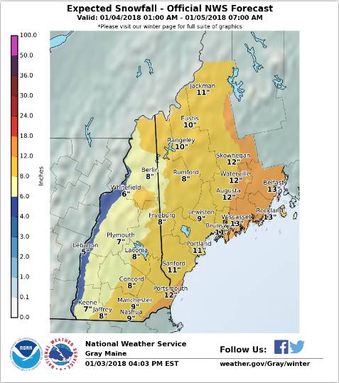
GRAY, MAINE – The latest forecast from the National Weather Service is calling for up to 14 inches of snow in some locations. According to the NWS probability forecast, Manchester is in for 9-12 inches.
Low pressure developing east of the Carolinas Wednesday evening will rapidly intensify as it moves up the eastern seaboard to a position off the New England coast on Thursday and into the Canadian maritimes Thursday night. This storm is forecast to bring heavy snow and strong winds, especially to coastal sections of western Maine and New Hampshire, where blizzard conditions are expected.
As this storm departs on Friday, bitterly cold air will arrive from Canada, along with strong northwesterly winds.
The storm will feature heavy snow and blowing snow. Residents should plan on difficult travel conditions, including during the evening commute on Thursday. Total snow accumulations of 7 to 10 inches, with localized amounts up to 14 inches, are expected for portions of New Hampshire and western Maine.
Snow should begin anytime around 7 a.m. Thursday and continue until 4 a.m. Friday. Winds gusting as high as 35 mph will cause areas of blowing and drifting snow.
A Winter Storm Warning for snow and blowing snow means severe winter weather conditions are expected. If you must travel, keep an extra flashlight, food and water in your vehicle in case of an emergency. For a more precise forecast for your specific location go to www.weather.gov/gray.
Extended forecast:
Wednesday nightA 20 percent chance of snow showers after 4am. Increasing clouds, with a low around 5. Wind chill values as low as -4. South wind around 5 mph becoming calm.ThursdaySnow. Areas of blowing snow after 1pm. High near 25. Wind chill values as low as -1. Blustery, with a north wind 5 to 10 mph increasing to 15 to 20 mph in the afternoon. Chance of precipitation is 100%. New snow accumulation of 5 to 9 inches possible.Thursday NightSnow likely, mainly before 8 p.m. Areas of blowing snow. Mostly cloudy, with a low around 7. Wind chill values as low as -7. Blustery, with a northwest wind around 20 mph, with gusts as high as 30 mph. Chance of precipitation is 60 percent. New snow accumulation of 1 to 2 inches possible.FridayAreas of blowing snow. Partly sunny and cold, with a high near 8. Wind chill values as low as -15. West wind around 15 mph, with gusts as high as 30 mph.Friday NightMostly cloudy, with a low around -7. West wind around 15 mph.SaturdayMostly sunny and cold, with a high near 1.Saturday NightMostly clear, with a low around -15.SundayMostly sunny, with a high near 13.Sunday NightMostly cloudy, with a low around 4.MondayA 40 percent chance of snow. Mostly cloudy, with a high near 29.Monday NightSnow likely. Cloudy, with a low around 23. Chance of precipitation is 70%.TuesdayA 40 percent chance of snow. Mostly cloudy, with a high near 33.Tuesday NightMostly cloudy, with a low around 15.WednesdayMostly sunny, with a high near 22.


