
Saturday’s weather: Sunny, breezy, pleasant and high of 78
Today partly to mostly sunny, breezy, and pleasant, signaling the start of an extended dry spell. The high will be 78 degrees.


Weather Watch with Rick Gordon
Click below for Rick’s exclusive videocast.
Saturday’s Weather
Today partly to mostly sunny, breezy, and pleasant, signaling the start of an extended dry spell. The high will be 78 degrees.
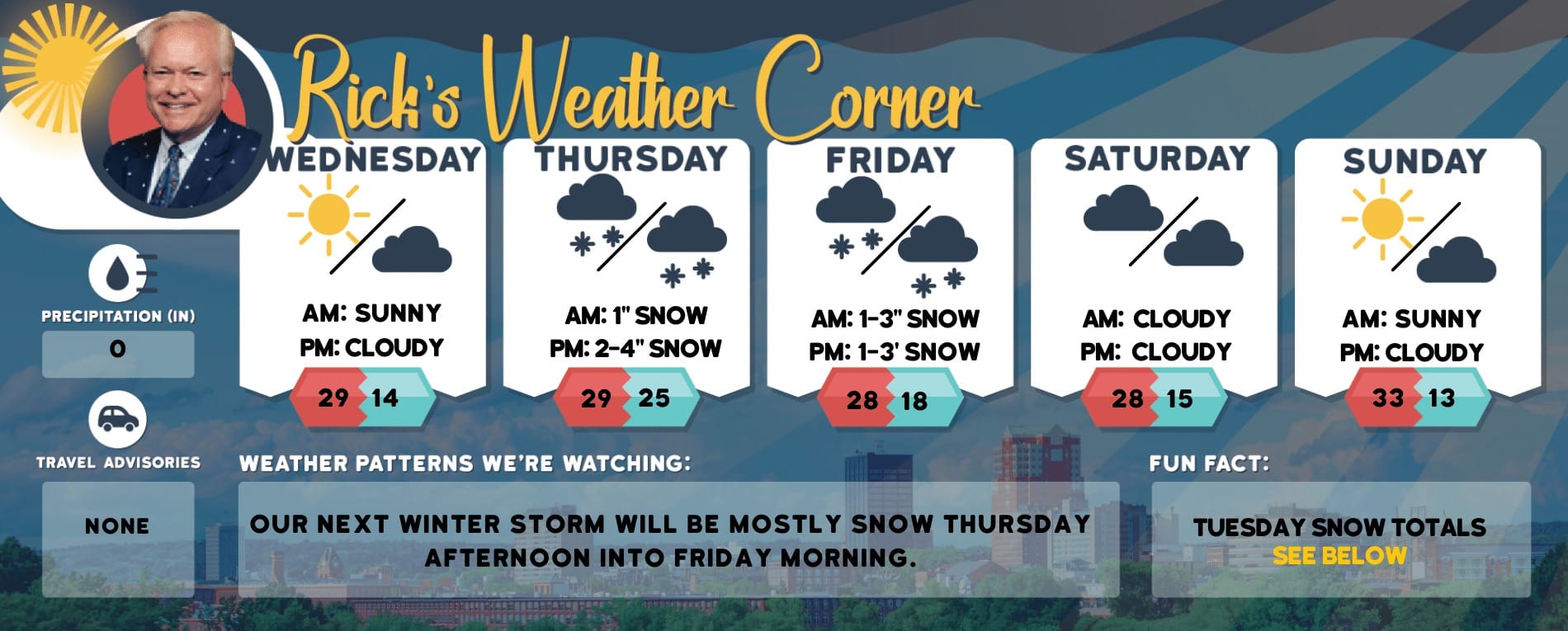
5-Day Forecast June 15-19
Today: Partly to mostly sunny, breezy, and pleasant, marking the beginning of a prolonged period of dry weather. High 78 Winds: NNW 10-20 mph
Tonight: Mostly clear and crisp. Low 48 Wind: NNW5-15 mph
Father’s Day: Comfortable sunshine & few clouds. High 79 Winds: Light & Variable
Sunday night: Partly cloudy. Low 57 Winds: S 5-10 mph
Monday: Some sun & clouds. High 85 Winds: SW 5-10 mph
Monday night: Some clouds & more humid. Low 65 Winds: SSW 5-10 mph
Tuesday: Hazy sun, hot, and muggy with a record high. High 95 (feel like 100) breaking the record of 94 set in 2018.
Tuesday night: Hazy, muggy, and warm. Low 71 tying the record for a record-high low set in 2006
Wednesday: Hazy sun, very hot, and muggy. High 99 (feel like 104) breaking the record of 96 set in 1941.
Wednesday night: Hazy, muggy, and warm. Low 74 tying the record for a record-high low set in 2012.
The Heat is On
Next week’s escalating heat and humidity will create conditions reminiscent of July, with temperatures approaching record highs. The season’s first heat wave is expected to begin on Tuesday, becoming an official heat wave by Thursday, coinciding with the start of astronomical summer. https://manchester-ink-link.ghost.io/content/images/manchester-local/wp-content/uploads/2022/10/610temp-new_-scaled-1.gif
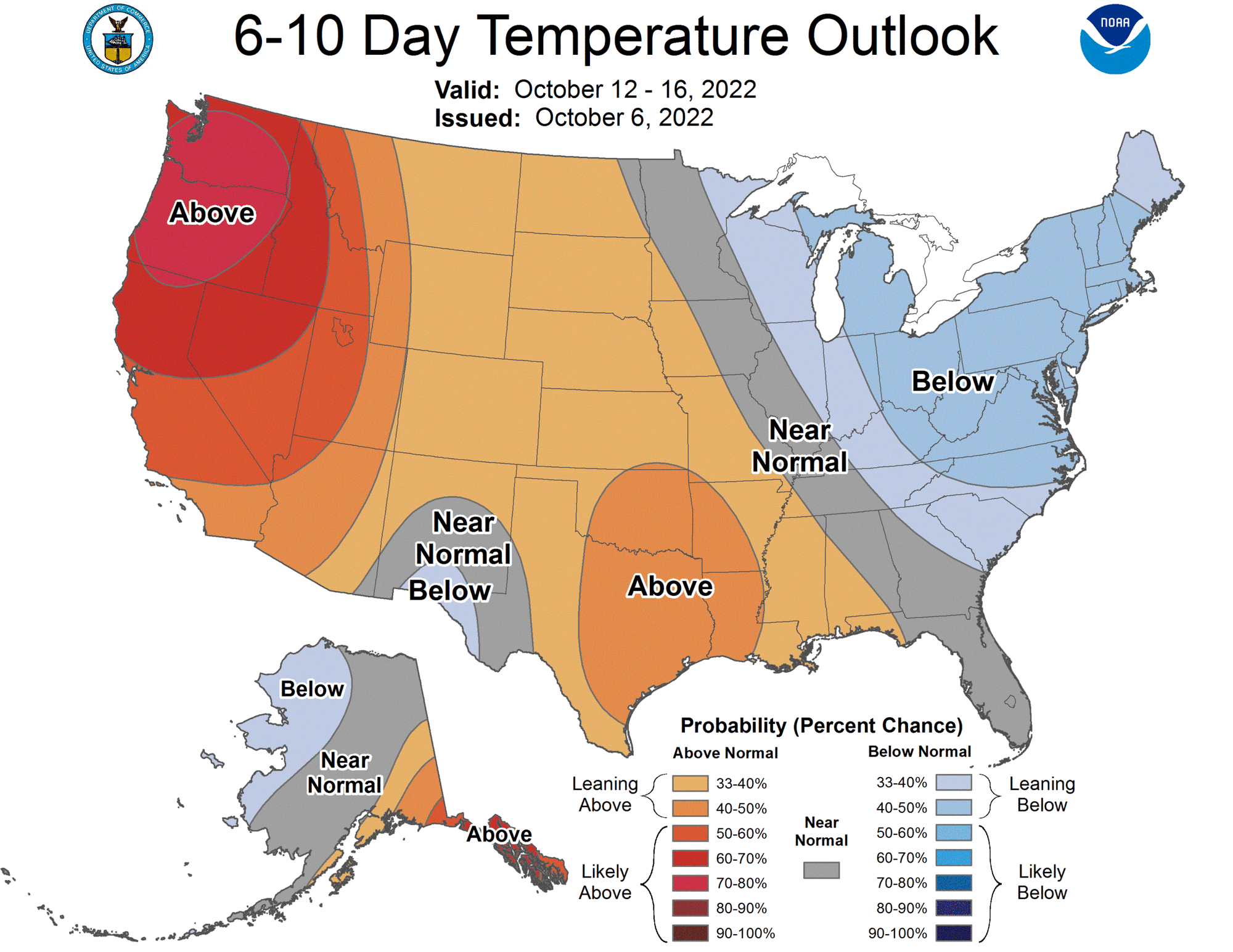
Weather Patterns We’re Watching
Next Thursday and Friday temperatures hit record heat with highs of 100-104 degrees approaching Manchester’s record high of 105 degrees. The heat index will be dangerously high.
Hiking/Beach/Lake Forecasts

Take a Hike
Elevations for summits above 4,000 feet in Northern New Hampshire Today: In the morning, summits will be obscured, followed by summits appearing intermittently through the clouds. Temperatures will reach the mid-50s, except for areas above 5,000 feet where it will be in the upper 40s. Expect northwest winds at 15 to 25 mph, with gusts up to 50 mph.
Elevations between 2,500 and 4,000 feet in Northern New Hampshire Today: Morning summits will be shrouded in clouds before clearing up. Expect highs around 60 degrees. Northwest winds will blow at 10 to 20 mph, with gusts reaching up to 40 mph.
Hit the Beach
Weather: Partly sunny until 4 PM, then sunny.
Thunderstorm Potential: None.
High Temperature: In the lower 70s.
UV Index: High.
Winds: Northeast winds around 10 mph.
Surf Height: Around 2 feet.
Rip Current Risk: Low.
Tides Hampton Beach: High 7.4 feet (MLLW) 06:46 AM. Low 1.4 feet (MLLW) 01:13 PM.
Jump in a Lake
Northwest winds 10 to 15 mph with gusts up to 25 mph. Waves 2 to 4 feet. Patchy fog in the morning. Mostly sunny. Highs in the lower 70s. Thunderstorms are not forecast for this period. The water temperature is 68 degrees.


