
Saturday’s weather: Sun, then clouds with a high of 41
Today is dry & milder as we start the holiday weekend with highs in the lower 40s. Above-normal temperatures will persist through Christmas day and last through the middle of next week.

Weather Watch with Rick Gordon
Below: Watch your weather outlook via YouTube, delivered in two minutes.
Saturday’s WeatherToday is dry & milder as we start the holiday weekend with highs in the lower 40s. Above-normal temperatures will persist through Christmas day and last through the middle of next week.
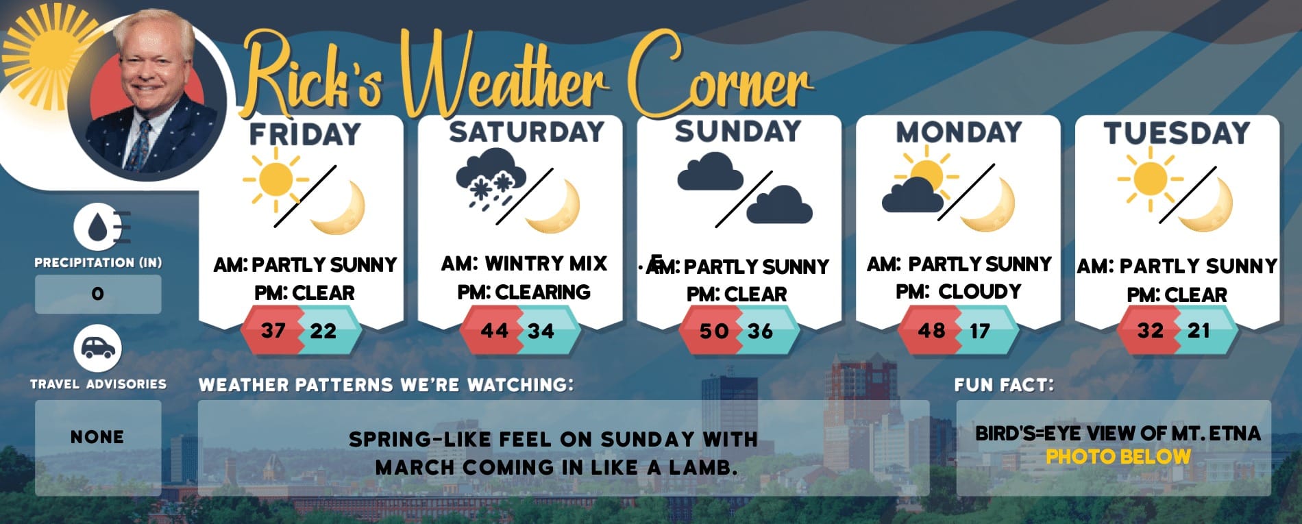
5-Day Outlook, Dec. 23 – 27Today: Some sun then clouds & milder. High 41 Winds: SSW 5-10 mph Tonight: Some clouds & not as cold. Low 30 Winds: SSW 5-10 mphChristmas Eve Day: Mostly cloudy & mild. High 45 Winds: Light & VariableChristmas Eve: Some clouds & mild for Santa. Low 34 Winds: Light & VariableChristmas: Some sunny breaks & mild. High 49 Winds: Ligh & VariableMonday night: Mostly cloudy & mild. Low 37 Winds: Light & VariableTuesday: Mostly cloudy & mild. High 52 Winds: SSW 5-10 mphTuesday night: Mostly cloudy with showers moving in late. Low 42 Winds: Light & VariableWednesday: Periods of rain (.40″) and mild. High 53 Winds: E 5-10 mphWednesday night: Early thunderstorm or a shower & mild. Low 44 Winds: SSE 5-10 mph
Weather Patterns We’re Watching
New Year’s Eve forecast: Mainly clear and mild. Low 30 Winds: NW 5-10 mph

Hiking Report/White Mountains Weather
Elevations for summits above 4,000 feet in Northern New Hampshire Today: Mostly cloudy. Highs in the upper 20s. West winds 10 to 15 mph with gusts up to 35 mph.
Elevations between 2,500 and 4,000 feet in Northern New Hampshire Today: Mostly cloudy. Highs in the upper 20s. Southwest winds up to 10 mph with gusts up to 25 mph.

Check for opening dates for Ski NH resorts.