
Weather Watch: Snow, freezing rain moving in, potential for 4-8 inches Saturday, Sunday ice storm
Expect a chilly day ahead, with overcast skies and the promise of snow showers rolling in by evening with steadier snow at night. Get ready to cozy up as temperatures reach a high of 29 degrees!


Rick Gordon’s Weather Watch
Follow our YouTube channel here.
Today’s weather
Expect a chilly day ahead, with overcast skies and the promise of snow showers rolling in by evening with steadier snow at night. Get ready to cozy up as temperatures reach a high of 29 degrees! A winter parking ban is in effect for Manchester overnight Saturday into Sunday. Potential for major power outages due to high winds Monday.
5-Day Outlook
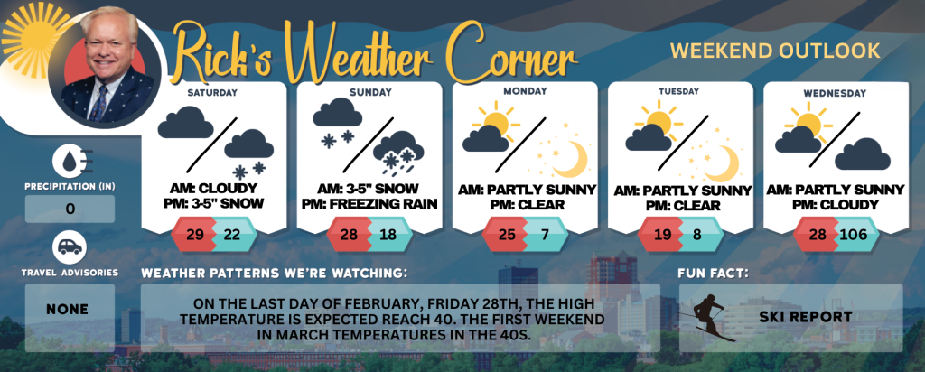
Saturday: Cloudy with snow showers developing by evening. High 29 Winds: Light & Variable
Saturday night: Watching a potential winter storm. Periods of snow (3-5″) Low 22 (feel like 17) Winds: ENE 5-15 mph
Sunday: Watching a potential winter storm. Snow (1-3″) turning to freezing rain & sleet. High 28 (fee like 15) Winds: NE 10-20 mph
Sunday night: Some freezing rain; ice on roadways and sidewalks can make travel difficult. Low 18 (feel like 2) Winds: NW 10-20 mph
Presidents Day: Frigid with a gusty wind that could gust over 40 mph with clouds & sun. High 25 (feel like 5) Winds: WNW 20-30+ mph
Monday night: Becoming clear, very windy, and frigid. Low 7 (feel like -14) Winds: WNW 15-25+ mph
Tuesday: Mostly sunny, windy (winds could occasionally gust over 40 mph), and frigid. High 19 (feel like -1) Winds: WNW 20-25+ mph
Tuesday night: Mainly clear, breezy, and frigid. Low 8 (feel like -7) Winds: WNW 10-15 mph
Wednesday: Breezy and not as cold with some sun & clouds. High 28 (feel like 19) Winds: WNW 10-15 mph
Wednesday night: Some clouds & very cold. Low 10 (feel like 3) Winds: WNW 5-15 mph A major winter storm can impact the area later this week; check back often for updates.

Weekend Weather Advisory
Preparing for a Snowstorm and Ice storm. This weekend, we are anticipating a significant winter weather event beginning with a snowstorm on Saturday night. Here’s what you can expect:
Saturday Night: Snowstorm Arrival.
- Snowfall is projected to range from 3 to 5 inches.
- The snow will start accumulating later in the evening.
Sunday Morning: Transitioning Weather.
- Expect an additional accumulation of 1 to 3 inches of snow throughout the morning.
- As temperatures change, the snow will transition into sleet and freezing rain.
Snow Accumulation Summary.
- For the areas of Manchester and Nashua, total snow accumulation is forecasted to be between 4 to 8 inches.
- Alongside the snow, there could be a layer of sleet and ice forming, estimated to be between 0.50 to 1 inch thick.
Impact on Ski Areas.
- Ski country likely to receive even more snow, with predictions of 1 to 2 feet of fresh powder, providing excellent conditions for winter sports enthusiasts.
Potential Hazards: Freezing Rain.
- It’s important to note that if freezing rain predominates over sleet, it could pose a risk to trees and power lines, making them vulnerable to damage and major power outages.
Monday Outlook.
- Preparing for Monday, we expect very windy conditions and temperatures that will remain below freezing. This scenario could result in major power outages, so it’s wise to have an emergency plan in place.
Conclusion: Stay Prepared.
- As we approach this winter storm, it’s essential to stay informed and take necessary precautions. Ensure your emergency supplies are stocked and consider adjusting travel plans if needed. Stay safe and warm!
Weather Patterns We’re Watching
On the last day of February, Friday 28th, the high temperature is expected reach 40. The first weekend in March temperatures in the 40s.
Skiing and Snowboarding Weather Report
Elevations for summits above 4,000 feet in New Hampshire today: Cloudy in the morning, then summits becoming obscured. Highs around 12. Northwest winds around 35 mph becoming west around 20 mph in the afternoon. At elevations above 5,000 feet, northwest winds around 55 mph becoming west and decreasing to around 30 mph in the afternoon. Gusts up to 75 mph. Wind chill values as low as 42 below.
Elevations between 2,500 and 4,000 feet in Northern New Hampshire today: Cloudy in the morning, then summits becoming obscured. Highs 9 to 19 above. Northwest winds around 25 mph decreasing to around 15 mph in the afternoon. Gusts up to 60 mph. Wind chill values as low as 37 below.


