
Saturday’s weather: Partly sunny, high of 46
Today will be partly to mostly cloudy with highs in the middle 40s.

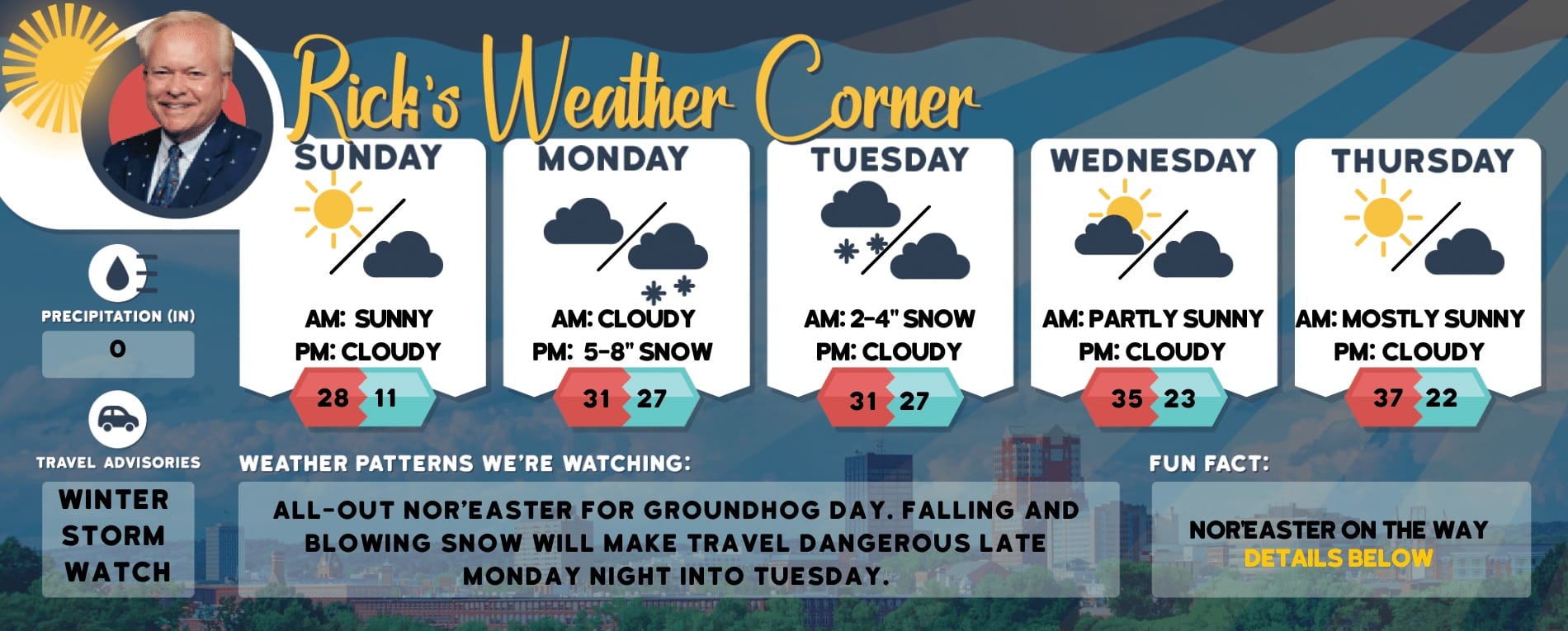
Weather Watch with Rick Gordon
Below: Watch your weather outlook via YouTube, delivered in two minutes.
Saturday’s Weather
Today will be partly to mostly cloudy with highs in the middle 40s.
5-Day Outlook, March 9-13Today: Partly to mostly cloudy. High 46 Winds: SE 5-10 mphTonight: (Set clocks ahead 1 hour.) Cloudy & windy with rain (.80″) late. Low 37 Winds: ESE 10-20+ mphSunday: Morning rain (.25″) with some afternoon sunshine. High 49 (feel like 42) Winds: Shifting to NW at 10 to 20+ mph Sunday night: Breezy with some light snow late (less than 1″) Low 32 (feel like 18) Winds: NW 10-20 mphMonday: Mostly cloudy & very windy with flurries in the morning. High 43 (feel like 32) Winds: NW 20-30+ mphMonday Night: Partly cloudy & windy. Low 32 (feel like 18) Winds: NW 15-25+ mphTuesday: Breezy with lots of sun. High 50 (feel like 42) Winds: NW 10-20 mphTuesday night: Mainly clear & breezy. Low 30 (feel like 20) Winds: NW 10-15 mphWednesday: Milder with a mix of sun & clouds. High 57 Winds: WNW 5-10 mphWednesday night: Partly cloudy. Low 35 Winds: Light & Variable
Weather Alert
Another system moves in late tonight through tomorrow morning with around 1″ of rain. Heavy rain can cause flooding on streets and poor drainage areas and lead to slow travel. High astronomical tides will continue to increase through this weekend. Minor to moderate coastal flooding is a possibility for noon high tide Sunday depending on the track of low pressure, resulting surge, winds, and high seas. Subsequent high tides may also produce minor flooding on Sunday evening and Monday morning.
FLOOD WATCH IN EFFECT FROM SUNDAY MORNING THROUGH SUNDAY AFTERNOON.
WHAT: Urban, small streams and flash flooding caused by excessive rainfall is possible.
WHERE: Belknap, Coastal Rockingham, Eastern Hillsborough, Interior Rockingham, Merrimack, Southern Carroll, and Strafford counties.
WHEN: From Sunday morning through Sunday afternoon.
IMPACT: Excessive runoff may result in flooding of rivers, creeks, streams, and other low-lying and flood-prone locations.
ADDITIONAL DETAILS: Heavy rain will fall on saturated and partially frozen ground conditions causing rapid runoff. This runoff will cause already swollen small streams to flood.
Weather Patterns We’re WatchingNext week the above-normal temperatures will continue along with mainly dry conditions.

Hiking Report/White Mountains Weather
Elevations for summits above 4,000 feet in Northern New Hampshire Today: Summits obscured. A chance of snow in the afternoon. Highs in the upper 20s. South winds 20 to 30 mph with gusts up to 70 mph. Chance of snow 30 percent. Wind chill values are as low as 2 below in the afternoon.
Elevations between 2,500 and 4,000 feet in Northern New Hampshire Today: Summits obscured. Highs in the mid-30s. Southeast winds 15 to 25 mph with gusts up to 55 mph. Wind chill values are as low as zero.

Click here to check out the current conditions at NH Ski Resorts!