
Saturday’s weather: Muggy, with T-storms and potential flash flooding
Expect muggy conditions with a morning thunderstorm in some areas, followed by a strong thunderstorm in the afternoon. These thunderstorms could lead to flash flooding and localized damaging wind gusts. High 88° (feels like 96°)


Weather Watch with Rick Gordon
Click below for Rick’s exclusive videocast
Saturday’s Weather
Expect muggy conditions with a morning thunderstorm in some areas, followed by a strong thunderstorm in the afternoon. These thunderstorms could lead to flash flooding and localized damaging wind gusts. High 88° (feels like 96°)
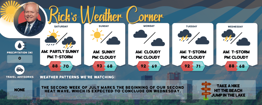
5-Day Forecast July 6-July 10
Today: Muggy; expect a morning thunderstorm in areas, with a potent thunderstorm in the afternoon. These thunderstorms may cause flash flooding and localized damaging wind gusts. High 88 (feel like 96) Winds: SSW 10-15 mph
Tonight: Expect scattered thunderstorms in the evening, followed by partly cloudy skies & muggy conditions overnight. Low 70 Winds: S 5-10 mph
Sunday (Start of our 2nd heat wave): Hazy sun, hot, and not as muggy; but still humid. High 93 (feel like 97) Winds: SSW 5-10 mph
Sunday night: Some clouds & humid. Low 68 Winds: Light & Variable
Monday: Hot with hazy sun & humid. High 92 (feel like 98) Winds: SSE 5-10 mph
Monday night: Some clouds & humid. Low 69 Winds SSE 5-10 mph
Tuesday: Mostly cloudy with heat; expect sporadic morning rain and a thunderstorm, then isolated thunderstorms in the afternoon. High 92 (feel like 94) Winds: SSW 5-10 mph
Tuesday night: Cloudy, warm, and humid. Low 72 Winds: S 5-10 mph
Wednesday: Mostly cloudy & humid with occasional rain and a thunderstorm expected in the morning, followed by scattered thunderstorms in the afternoon. High 88 (feel like 92) Winds: WSW 5-10 mph
Wednesday night: Partly cloudy & humid. Low 68 Winds: WSW 5-10 mph
Weather Patterns We’re Watching
The second week of July marks the beginning of our second heat wave, which is expected to conclude on Wednesday.
Hiking/Beach/Lake Forecasts
Take a Hike
Elevations for summits above 4,000 feet in Northern New Hampshire Today: The summits will be obscured, with showers likely and a possibility of thunderstorms. Temperatures will reach the upper 60s. Expect southwest winds at 10 to 15 mph, gusting up to 30 mph. The probability of rain is 80 percent.
Elevations between 2,500 and 4,000 feet in Northern New Hampshire Today: Expect cloudy skies with showers and possible thunderstorms. Temperatures will reach the lower 70s. Winds will be light and variable, shifting to the southwest at around 10 mph in the afternoon, with gusts up to 25 mph. The likelihood of rain is 90 percent.
Hit the Beach
- Weather: Mostly cloudy. Patchy fog. Showers are likely and a chance of thunderstorms.
- UV Index: Moderate
- Thunderstorm Potential: Moderate. Implies that thunderstorms are possible.
- High Temperature: In the mid-70s.
- Winds: South winds around 5 mph.
- Water Temperature: 60 degrees.
- Surf Height: Around 3 feet.
- Rip Tide Current Risk: Low.
- Tides Hampton Beach: Low -0.4 feet (MLLW) 06:40 AM. High 8.1 feet (MLLW) 12:36 PM.
Jump in a Lake
Expect south winds at 5 to 10 mph with waves around one foot. The morning may bring patchy fog, followed by likely showers and a chance of thunderstorms. It will be humid with high temperatures in the upper 70s. The probability of rain is 70 percent, and there is a high lightning threat, indicating probable or expected thunderstorms. The water temperature will be around 70 degrees.


