
Saturday’s weather: Chilly breeze with rain or snow showers, high of 44
Today low pressure will linger in the Gulf of Maine for continued chances of rain & snow showers along with a chilly breeze with highs in the middle 40s but feeling like the upper 30s.

Weather Watch with Rick Gordon
Click below for Rick’s exclusive videocast.
Saturday’s Weather
Today low pressure will linger in the Gulf of Maine for continued chances of rain & snow showers along with a chilly breeze with highs in the middle 40s but feeling like the upper 30s.
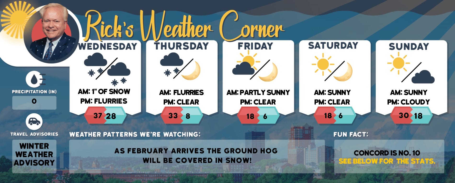
5-Day Outlook, April 6-April 10Today: Chilly breeze with a few afternoon rain or snow showers. High 44 (feel like 37) Winds: NNW 10-20 mphTonight: Cloudy & breezy with a few early showers. Low 34 (feel like 31) Winds: N 10-15 mphSunday: Cloudy with some sunny breaks. High 53 (feel like 46) Winds: N 10-15 mphSunday night: Mainly clear. Low 33 Winds: Light & VariableMonday (Solar Eclipse): Warmer with mostly sunny sky and great viewing conditions. High 62 Winds: NW 5-10 mphMonday night: Mainly clear. Low 38 Winds: WNW 5-10 mphTuesday: Mostly sunny & nice. High 61 Winds: Light & VariableTuesday night: Clear to partly cloudy. Low 37 Winds: E 5-10 mphWednesday: Mostly cloudy and cooler. High 50 Winds: SE 5-10 mphWednesday night: Mostly cloudy with periods of rain (.25″) Low 41 Winds: SSE 5-10 mph
Solar Eclipse Weather Update
Solar Eclipse Weather Update The final countdown is underway for the astronomy event of the decade – a total solar eclipse for northern New Hampshire with a partial solar eclipse for the rest of the state. Monday’s forecast is warmer with a high of 62. We’ll keep you up to date on the forecast here.
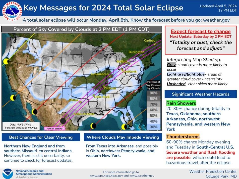
Weather Patterns We’re WatchingWarmer next Monday & Tuesday with temperatures in the low 60s, with a few showers by week’s end.
Hiking Report/White Mountains Weather
**The US Forest Service Mount Washington Avalanche Center has issued a backcountry avalanche warning. This avalanche warning does not apply to operating ski areas.
Elevations for summits above 4,000 feet in Northern New Hampshire Today: Summits obscured. Snow (1-2″) likely. Highs in the upper 20s. North winds 20 to 30 mph with gusts up to 55 mph. The chance of snow is 70 percent. Wind chill values are as low as 9 below.
Elevations between 2,500 and 4,000 feet in Northern New Hampshire Today: Summits in and out of clouds. Snow (1″) likely. Highs in the lower 30s. North winds 15 to 25 mph with gusts up to 45 mph. The chance of snow is 70 percent. Wind chill values as low as 2 above.

Click here to check out the current conditions at NH Ski Resorts!