
Roller coaster weather weekend – warm, sunny and dry, then temp drop Sunday, possible late flurries
The first weekend of spring is expected to be dry with some sunshine. It will start off mild but end up feeling chilly.


Rick Gordon’s Weather Watch
Follow our YouTube channel here.
Weekend Headlines
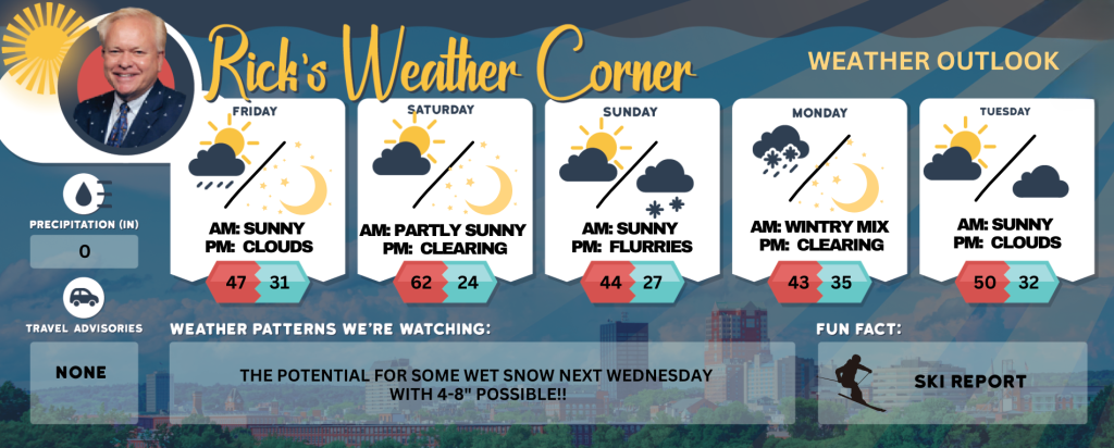
The first weekend of spring is expected to be dry with some sunshine. It will start off mild but end up feeling chilly. On Saturday, temperatures will be in the low 60s, creating a pleasant spring-like atmosphere. However, on Sunday, temperatures will drop to the mid-40s, and with the wind, it will feel more like the 30s, the perfect opportunity to embrace the outdoors and soak in the refreshing vibes of the season!
5-Day Outlook
Today: Windy and cooler conditions with morning rain (0.25″), followed by clouds breaking for afternoon sunshine. High 47 (feel like 38) Winds: NW 20-30+ mph (gusts over 40 mph possible)
Tonight: Mainly clear, windy, and colder. Low 31 (feel like 27) Winds: WNW 10-20 mph
Saturday: Breezy with morning sun followed by some afternoon clouds and mild. High 62 (feel like 58) Winds: SW 10-20 mph
Saturday night: Clearing, breezy, and cold. Low 24 (feel like 10) Winds: WNW 10-20 mph
Sunday: Mainly sunny, windy, and cooler. High 44 (feel like 34) Winds: NW 15-20+ mph
Sunday night: Increasing clouds with flurries late & chilly. Low 27 Winds: SE 5-10 mph
Monday: Cold rain that may be mixed with some snow. High 43 (feel like 37) Winds: ESE 5-10 mph
Monday night: Early showers with some clearing late. Low 35 Winds: Light & Variable
Tuesday: Some sun & clouds. High 50 (feel like 45) Winds: WSW 10-15 mph
Tuesday night: Partly cloudy & chilly. Low 32 Winds: WNW 5-10 mph
Weather Patterns We’re Watching
The potential for some wet snow next Wednesday with 4-8″ possible!!
Skiing and Snowboarding Weather Report
Elevations for summits above 4,000 feet in New Hampshire Friday: Summits obscured. Rain likely in the morning changing to Snow (2-4″). Highs in the lower 30s. Northwest winds around 40 mph increasing to around 60 mph in the afternoon. Gusts up to 90 mph. Chance of precipitation 80 percent. Wind chill values as low as 7 below in the afternoon.
Elevations between 2,500 and 4,000 feet in Northern New Hampshire Friday: Summits obscured. Rain in the morning changing to Snow (1-3″). Highs in the mid 30s. West winds around 25 mph increasing to northwest around 35 mph in the afternoon. Gusts up to 80 mph. Chance of precipitation 80 percent. Wind chill values as low as 1 above in the afternoon.


