
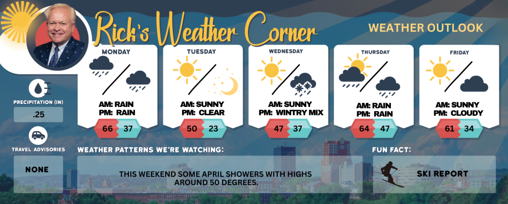
Monday’s weather: Warmer but gray and cloudy, high of 66
For the last day of March, expect a mostly cloudy and noticeably warmer day ahead, beginning with brief morning showers that will give way to light rain in the afternoon. The high will reach 66 degrees, with gentle winds coming from the south-southwest at 5 to 15 mph. Don’t forget your umbrella as y


Rick Gordon’s Weather Watch
Follow our YouTube channel here.
Today’s Weather
For the last day of March, expect a mostly cloudy and noticeably warmer day ahead, beginning with brief morning showers that will give way to light rain in the afternoon. The high will reach 66 degrees, with gentle winds coming from the south-southwest at 5 to 15 mph. Don’t forget your umbrella as you head out.
Weather Alerts
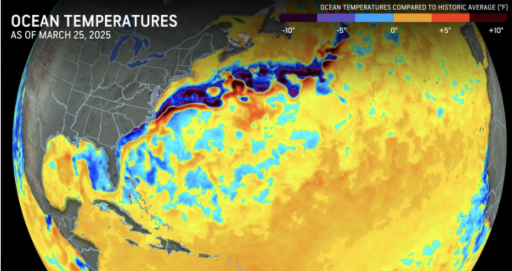
The forecast for the 2025 Atlantic hurricane season is being described as both “dynamic” and potentially more volatile than average. The Atlantic hurricane season commences on June 1, and preliminary indications have raised concerns among forecasters that it may bear similarities to the 2024, which was one of the most devastating and costliest on record. **Keys to Hurricane Forecasting** One of the biggest factors influencing tropical development in 2025 is the abundance of warm water that fuels storms. Ocean water temperatures, as well as those in the Gulf of Mexico and the Caribbean, are currently well above historical averages and are expected to remain warm throughout much of the year. This situation creates ideal conditions for storms to develop explosively.
5-Day Outlook
Today: Mostly cloudy, breezy, and warmer, with a brief shower or two in morning, followed by light rain in the afternoon. High 66 Winds: SSW 10-15+ mph
Tonight: A few evening showers and a potential thunderstorm, followed by breezy conditions and intermittent rain. Low 37 (feel like 29) Winds: WSW 10-15+ mph
Tuesday (April 1st): Mostly sunny, windy, and cooler. High 50 (feel like 43) Winds: NW 20-25+ mph
Tuesday night: Mainly clear, breezy, & colder. Low 23 (feel like 20) Winds: NW 10-15+ mph
Wednesday: Morning sun with afternoon clouds & cool. High 47 Winds: SSW 5-15 mph
Wednesday night: Cloudy with light snow to showers late. Low 37 Winds: SSE 5-10 mph
Thursday: Morning rain; otherwise, considerable cloudiness and warmer, becoming breezy in the afternoon. High 64 (feel like 59) Winds: SSW 15-20+ mph
Thursday night: Evening showers with partial clearing late. Low 47 Winds: W 5-15 mph
Friday: Some sun and mild. High 61 Winds: NW 5-15 mph
Friday night: Partly cloudy & chilly. Low 34 Winds: NW 5-10 mph
Weather Patterns We’re Watching
This weekend some April showers with highs around 50 degrees.
Skiing and Snowboarding Weather Report
Elevations for summits above 4,000 feet in New Hampshire today: Summits obscured. A chance of rain in the morning, then a chance of rain showers in the afternoon. Highs in the mid 40s. Southwest winds 35 to 45 mph… except southwest 50 to 60 mph at elevations above 5000 feet. Chance of rain 50 percent.
Elevations between 2,500 and 4,000 feet in Northern New Hampshire today: Summits obscured. A chance of rain in the morning, then a chance of rain showers in the afternoon. Highs in the upper 40s. Southwest winds 15 to 25 mph with gusts up to 65 mph. Chance of rain 50 percent. Wind chill values as low as 17.


