
Monday’s weather: Sunny and mild, high of 48, with snow starting late and into Tuesday
Today will be another mild day with highs in the upper 40s with lots of sunshine.

Weather Watch with Rick Gordon
Below: Watch your weather outlook via YouTube, delivered in two minutes.
Monday’s Weather
Today will be another mild day with highs in the upper 40s with lots of sunshine.
Snow Forecast

Heavy snowstorm expected with snow starting at 2 a.m. Tuesday and ending at 6 p.m. Tuesday. Snow totals 7-12″. Tuesday morning commute will be a slow one with snow-covered roads.
WINTER STORM WATCH IN EFFECT FROM LATE MONDAY NIGHT THROUGH TUESDAY EVENING.
WHAT: Heavy snow possible. Total snow accumulations greater than 6 inches possible.
WHERE: Portions of central and southern New Hampshire.
WHEN: From late Monday night through Tuesday evening.
IMPACTS: Roads, and especially bridges and overpasses, will likely become slick and hazardous. Periods of moderate and heavy snow will combine with low visibility to create dangerous driving conditions. The hazardous conditions could impact the Tuesday morning and evening commutes.
PRECAUTIONARY/PREPAREDNESS ACTIONS: Monitor the latest forecasts for updates here on INK LINK.
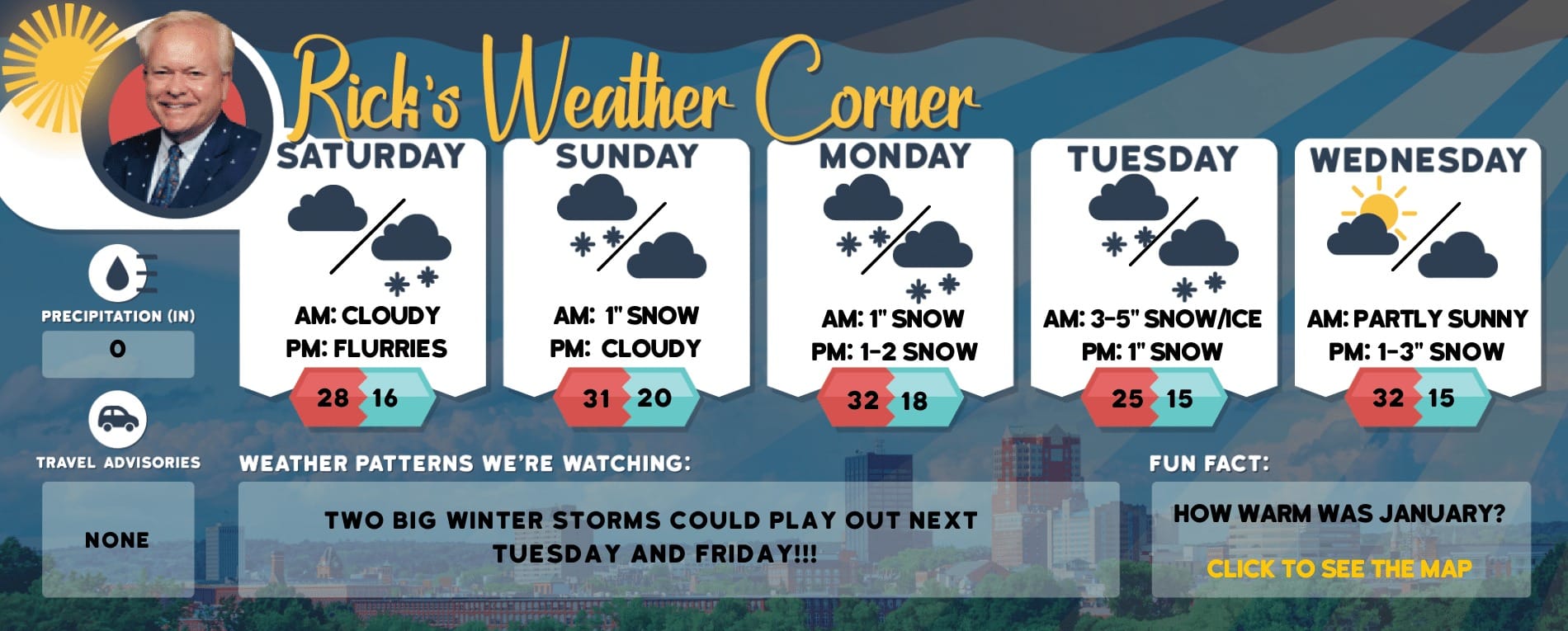
5-Day Outlook, Feb. 12-16
Today: Sunny & mild with some clouds by evening. High 48 Winds: WNW 5-10 mphTonight: Cloudy with some snow late; snow-covered roads for the morning commute. Low 29 Winds: N 5-15 mphTuesday: Cloudy, windy, and colder with snow (7-12″); potential for an impactful storm that will slow travel; check back to Ink Link for updates. High 34 (feel like 25) Winds: N 10-20+ mphTuesday night: Becoming partly cloudy. Low 21 (feel like 11) Winds: NW 10-15 mphValentine’s Day: Sunny, windy, & cold. High 29 (feel like 16) Winds: NW 15-25 mphWednesday night: Clear & breezy. Low 19 (feel like 5) Winds: NW 10-20 mph Thursday: Breezy & cold with some sun & clouds. High 33 (feel like 22) Winds: WNW 15-20 mphThursday night: Cloudy with snow late (1-2″). Low 25 Winds: Light & VariableFriday: Breezy with some sun & clouds. High 36 Winds: WNW 10-20 mphFriday night: Some clouds. Low 21(feel like 16) Winds: WNW 10-15 mph
Weather Patterns We’re Watching
Next weekend will be dry with highs in the low to middle 30s.

Hiking Report/White Mountains Weather
Elevations for summits above 4,000 feet in Northern New Hampshire Today: Summits obscured. Highs in the lower 20s. Northwest winds 20 to 30 mph with gusts up to 55 mph. Wind chill values as low as 17 below.
Elevations between 2,500 and 4,000 feet in Northern New Hampshire Today: Summits obscured. Highs in the lower 20s. Northwest winds 20 to 30 mph with gusts up to 55 mph. Wind chill values as low as 17 below.

Check for current conditions at Ski NH resorts here.