
Monday’s weather: Mostly cloudy and cooler, humid with a high of 76
Expect mostly cloudy skies, cooler temperatures, and humid conditions, with a chance of a few showers. The high will be 76 degrees, feeling like 79.


Weather Watch with Rick Gordon
Click below for Rick’s exclusive videocast
Monday’s Weather
Expect mostly cloudy skies, cooler temperatures, and humid conditions, with a chance of a few showers. The high will be 76 degrees, feeling like 79.
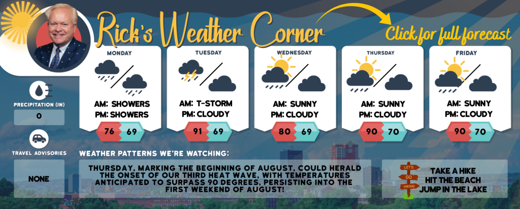
5-Day Forecast July 29-Aug. 2
Today: Mostly cloudy, cooler, and humid conditions with a few showers possible. High 76 (feel like 79). Winds: WSW 5-10 mph
Tonight: Some clouds & more humid with a few showers. Low 69 Winds: Light & Variable
Tuesday: Some sun, hot, & humid with a thunderstorm in spots in the afternoon. High 91 (feel like 94) Winds: SSW 10-15 mph
Tuesday night: Some clouds & humid. Low 69 Winds: S 10-15 mph
Wednesday (the last day of July): Some sun, not as warm, and muggy with spot afternoon thundershowers. High 80 (feel like 84) Winds: S 5-15 mph
Wednesday night: Mostly cloudy & muggy. Low 69 Winds: SSW 5-10 mph
Thursday (August 1st) Some sun, hot, and muggy with a hit-or-miss thunderstorm in spots. High 90 (feel like 96) Winds: WNW 5-15 mph
Thursday night: Some clouds, warm, and muggy. Low 70 Winds: Light & Variable
Friday: Some sun, muggy, and hot with a spotty thunderstorm in spots, High 90 (feel like 96) Winds: S 5-10 mph
Friday night: Some clouds, muggy, and warm. Low 70 Winds: Light & Variable
Weather Patterns We’re Watching
Thursday, marking the beginning of August, could herald the onset of our third heat wave, with temperatures anticipated to surpass 90 degrees, persisting into the first weekend of August!
Hiking/Beach/Lake Forecasts
Take a Hike
Elevations for summits above 4,000 feet in Northern New Hampshire Today: The summits will be obscured with a possibility of showers. Expect highs in the lower 60s. East winds will range from 10 to 15 mph, with gusts up to 25 mph. There is a 50 percent chance of rain.
Elevations between 2,500 and 4,000 feet in Northern New Hampshire Today: Summits will be obscured. There’s a possibility of showers later in the day. Expect highs in the upper 60s, with light and variable winds shifting to the east at around 10 mph in the afternoon. The chance of rain is 50 percent.
Hit the Beach
- Weather: Cloudy. Patchy fog is expected. There is a possibility of showers and a slight chance of thunderstorms.
- Thunderstorm Potential: A low chance of thunderstorms indicates that the probability of such weather events occurring is minimal.
- High Temperature: Around 70.
- Winds: Winds from the north at approximately 10 mph will shift to the south in the afternoon.
- Water Temperature: 61 degrees.
- Surf Height: 4 to 5 feet.
- Rip Tide Current Risk: Moderate. A moderate risk of rip currents suggests that anyone intending to enter the surf should first consult with local beach patrols. It’s crucial to swim near a lifeguard, never by yourself or during nighttime. Always bring a flotation device when in the water.
- Tides Hampton: High tide of 8.2 feet (Mean Lower Low Water) at 06:32 AM. Low tide of 0.6 feet (Mean Lower Low Water) at 12:49 PM.
Jump in a Lake
Northeast winds will be approximately 5 mph with wave heights around 1 foot. Expect patchy fog in the morning, followed by cloudy skies and a possibility of showers. There’s a slight chance of thunderstorms in the afternoon. Temperatures will be cooler, with highs in the lower 70s. The chance of rain is 50 percent. The low lightning threat indicates a minimal chance of thunderstorms. The water temperature will be 74 degrees.


