
Monday’s weather: Mix of clouds and sun, wind gusts up to 40 mph, high of 24, feels like 9
Prepare for cold conditions with strong winds gusting over 40 mph. Expect a mix of clouds and sun, along with potential localized power outages. Secure any loose objects to avoid damage. The high will reach 24°, but it will feel like 9°. Stay safe and alert!


Rick Gordon’s Weather Watch
Follow our YouTube channel here.
Today’s weather
Prepare for cold conditions with strong winds gusting over 40 mph. Expect a mix of clouds and sun, along with potential localized power outages. Secure any loose objects to avoid damage. The high will reach 24°, but it will feel like 9°. Stay safe and alert!
5-Day Outlook
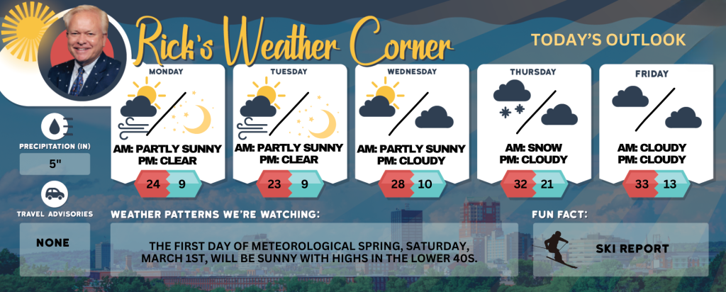
Presidents Day: Frigid with a gusty wind that could gust over 40 mph with clouds & sun; localized power outages; secure loose objects. High 24 (feel like 9) Winds: WNW 25-35+ mph
Tonight: Becoming clear, very windy, and frigid. Low 9 (feel like -14) Winds: WNW 20-30+ mph
Tuesday: Mostly sunny, very windy (winds could occasionally gust over 40 mph), and frigid. A major winter storm can impact the area on Thursday; check back often for updates. High 23 (feel like 3) Winds: WNW 20-30+ mph
Tuesday night: Mainly clear, breezy, and frigid. Low 8 (feel like -7) Winds: WNW 10-15 mph
Wednesday: Breezy and not as cold with some sun & clouds. High 28 (feel like 19) Winds: WNW 10-15 mph
Wednesday night: Some clouds & very cold. Low 10 (feel like 3) Winds: WNW 5-15 mph
Thursday: Cloudy with some snow or snow showers (1-2″). High 32 (feel like 21) Wind: NNW 10-15 mph
Thursday night: Cloudy. Low 21 (feel like 7) Winds: NW 10-15 mph
Friday: Lots of clouds and windy. High 33 (feel like 21) Winds: NW 15-20+ mph
Friday night: Partly cloudy & breezy. Low 13 (feel like 3) Winds: NW 10-15 mph
Weather Advisory

There is a significant concern regarding the winds today. The combination of gusts reaching up to 50 mph and the existing ice load could lead to power outages in some areas. Therefore, it’s advisable to have an emergency plan in place.
Snow Totals for Saturday into Sunday
Hillsborough County:
Nashua 6.1″
Milford 5.5″
Manchester Airport 5.5″
New Boston 4.9″
Merrimack County:
Tilton 7.8″
Hooksett 5.2″
Concord 5″
Contoocook 4.5″
Rockingham County:
Stratham 7.0″
Sandown 6.5″
Plaistow 5.8″
Exeter 5.5″
Chester 5.4″
Londonderry 5.2″
Strafford County:
Dover 7.0″
Durham 7.0″
Northwood 5.2″
Weather Patterns We’re Watching
The first day of Meteorological Spring, Saturday, March 1st, will be sunny with highs in the lower 40s.
Skiing and Snowboarding Weather Report
Elevations for summits above 4,000 feet in New Hampshire today: Summits obscured. A chance of snow showers. Highs around 1 above. West winds 50 to 60 mph. At elevations above 5,000 feet, west winds around 75 mph increasing to around 85 mph in the afternoon. Gusts up to 125 mph. Chance of snow 40 percent. Wind chill values as low as 52 below.
Elevations between 2,500 and 4,000 feet in Northern New Hampshire today: Summits obscured. A chance of snow showers. Highs around 5 above. West winds 35 to 45 mph with gusts up to 95 mph. Chance of snow 50 percent. Wind chill values as low as 37 below.


