
Monday’s weather: Hot and steamy with some wild storm action possible, high of 97
Very hot and turning steamy with clouds & sun. It sounds like you’re in for some intense weather! Make sure to stay safe and keep an eye on the forecast. Thunderstorms can be quite dramatic, especially with the potential for flash flooding and strong winds. High 97 (feel like 99) Winds SW 10-15 mph


Weather Watch with Rick Gordon
Click below for Rick’s exclusive videocast
Monday’s Weather
It sounds like a scorcher! Make sure to stay hydrated and find some shade when you can. Thunderstorms late this afternoon can be quite dramatic, especially with the potential for flash flooding and strong winds. With temperatures feeling like 99, staying hydrated and cool is also crucial. Stay safe!
Weather Alert
Today is the tenth straight day of 90-degree weather, making the second heat wave lasting over a week, with temperatures expected to remain at or above 90 degrees through Wednesday. A heavy thunderstorm is expected late this afternoon, bringing the potential for flash flooding and damaging winds. Stay safe and keep an eye on weather updates!
5-Day Forecast July 14-July 18
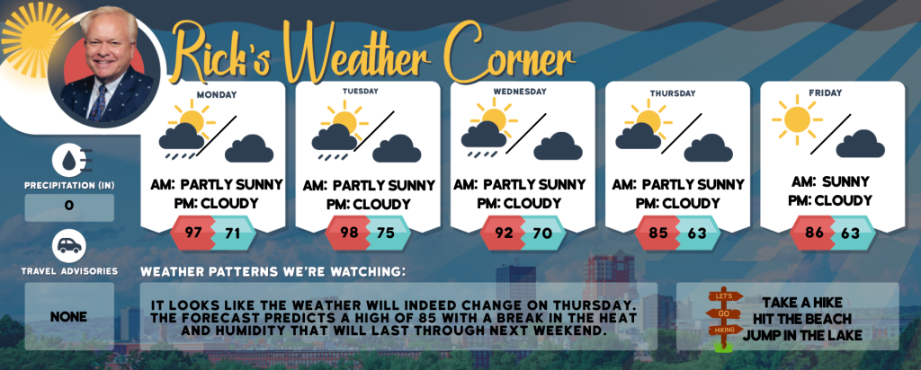
Today: Very hot and turning steamy with clouds & sun. It sounds like you’re in for some intense weather! Make sure to stay safe and keep an eye on the forecast. Thunderstorms can be quite dramatic, especially with the potential for flash flooding and strong winds. High 97 (feel like 99) Winds SW 10-15 mph
Tonight: Spotty thunderstorms during the evening, then some clouds, warm, & muggy. Low 71 Winds: SW 5-10 mph
Tuesday: Some sun, very hot, & muggy with a spot afternoon thunderstorm. High 98 (feel like 102) Winds: WSW 10-15 mph
Tuesday night: A thunderstorm in spots in the evening; otherwise, mainly clear, muggy, and warm. Low 75 Winds: SW 5-10 mph
Wednesday: Hot with clouds and sun; watch for a severe afternoon thunderstorm; thunderstorms can bring flooding downpours, hail, and damaging wind gusts. High 92 (feel like 99) Winds: WSW 10-15 mph
Wednesday night: Cloudy and humid; a couple of evening showers followed by occasional rain and a thunderstorm late. Low 70 Winds: WNW 5-10 mph
Thursday: Not as hot and turning less humid with some sun. High 85 Winds: WNW 5-15 mph
Thursday night: Some clouds. Low 63 Winds: NW 5–10 mph
Friday: Mostly sunny & comfortable. High 86 Winds: WNW 5-10 mph
Friday night: Few clouds. Low 63 Winds: WNW 5-10 mph
Weather Patterns We’re Watching
It looks like the weather will indeed change on Thursday. The forecast predicts a high of 85 with a break in the heat and humidity that will last through next weekend.
Hiking/Beach/Lake Forecasts
Take a Hike
Elevations for summits above 4,000 feet in Northern New Hampshire Today: It sounds like the weather will be quite variable! Expect some clouds around the summits, with a possibility of showers and thunderstorms in the afternoon. Temperatures will be in the mid-70s, and you’ll feel a west wind blowing at 10 to 20 mph, with gusts up to 35 mph. There’s a 40% chance of rain.
Elevations between 2,500 and 4,000 feet in Northern New Hampshire Today: Mostly cloudy skies and a chance of afternoon showers and thunderstorms, it might be a good idea to keep an umbrella handy. The temperatures in the upper 70s should be quite comfortable, but those southwest winds could get pretty gusty. Stay safe and enjoy your day!
Hit the Beach
- Weather: Mostly sunny. A chance of showers and thunderstorms.
- UV Index: Very high.
- Thunderstorm Potential: Moderate. Implies that thunderstorms are possible.
- High Temperature: In the lower 80s.
- Water Temperature: 60 degrees.
- Surf Height: Around 2 feet.
- Rip Tide Current Risk: Low.
- Tides Hampton Beach: High 7.1 feet (MLLW) 06:50 AM. Low 1.6 feet (MLLW) 01:03 PM.
Jump in a Lake
It sounds like a perfect day to enjoy the lake! With gentle west winds at 5 mph, waves less than 1 foot, and sunny skies with highs in the upper 80s, it’s ideal for some outdoor fun. Plus, with no thunderstorms forecasted and the water temperature at a comfortable 76 degrees, it’s a great time for a swim.


