
Got mittens? Wind chill + actual chill = bundle-up weather
Our Winter Weather Watcher sees some frigid temperatures on the horizon. Not only will temperatures dip into the single digits by Monday morning, but a persistent wind chill will keep the air temperature dangerously cold throughout the day.


MANCHESTER, NH — Our Winter Weather Watcher sees some frigid temperatures on the horizon. Not only will temperatures dip into the single digits by Monday morning, but a persistent wind chill will keep the air temperature feeling dangerously cold throughout the day.
According to the National Weather Service, temperatures Sunday will remain above freezing until about 8 p.m. when they start dropping as the wind slowly picks up. By Monday the temperature will sink into the single digits around 7 a.m. and continue to drop Monday night into Tuesday, when the windchill factor will make the air feel like -8 degrees at its lowest, before the mercury rises again.
That means make sure you’ve got your gloves, hats and scarves with you, bundle the kids up if they’re heading out to the bus stop or walking to school, and keep your cats and dogs safe from the elements.
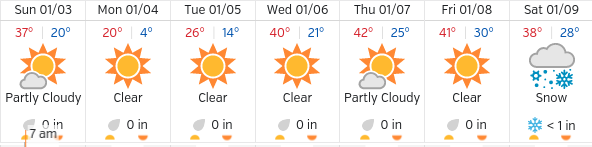
As you can see from the sunny outlook above, precipitation is not on the radar until Saturday Jan. 9, when we may get about an inch or so of snow in the Manchester area.
The regional NWS forecast out of our closest weather station in Gray, Maine, indicates the current conditions are due to a low pressure front moving east across southern Quebec, which will drive a cold front through New Hampshire late Sunday. High pressure will gradually build in from the West and crest over the region Tuesday, with another low pressure system moving north up the East Coast for next weekend, which will bring us some precipitation.
And of course, the 10-day forecast is always subject to change because, well, it’s winter in New Hampshire.
You’re one click away! Sign up for our free eNewsletter and never miss another thing


