
Get ready for snow: Back-to-back storms on the way
Be prepared for the wintry mix.

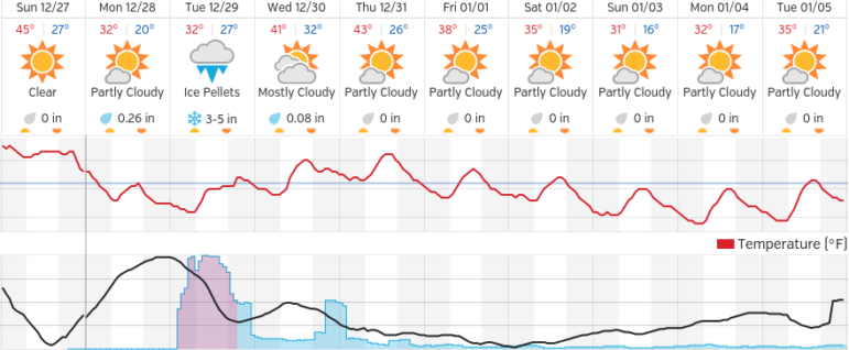
MANCHESTER, NH — A dip in temperatures could cause black ice overnight Sunday into Monday, and then — drum roll please — snow.
Yes, back-to-back storms Monday night and Tuesday morning will make for some wintry and hazardous weather conditions, and accumulation of 3 to 6 inches of snow here in Manchester, with even more up north – up to 10 inches.
According to the National Weather Service a winter weather advisory is in effect from 2 a.m. until 7 p.m. Dec. 28, calling for snow, sleet and freezing rain.
Snow will begin late Monday night, possibly heavy at times into Tuesday morning when it will begin to mix with sleet and freezing rain through the afternoon.
Expect hazardous travel conditions, including icy roads, poor visibility, isolated power outages and winds up to about 20 m.p.h. Temperatures will be in the 20s.
You’re one click away! Sign up for our free eNewsletter and never miss another thing


