
Friday’s weather: Heat alert in effect; hot & muggy, some sun with possible T-storm, high of 96
xpect hot and humid weather with periods of sunshine and clouds; there’s a chance of an afternoon spot thunderstorm. During strenu

Weather Watch with Rick Gordon
Click below for Rick’s exclusive videocast
Friday’s Weather
Expect hot and humid weather with periods of sunshine and clouds; there’s a chance of an afternoon spot thunderstorm. During strenuous activities, there is a risk of dehydration and heatstroke. The high will be 96 degrees, feeling like 100.
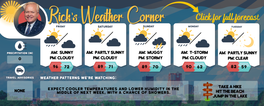
5-Day Forecast Aug. 2-Aug. 6
Today: Hot and muggy conditions with intervals of sunshine and clouds; an afternoon spot thunderstorm is possible. There’s a risk of dehydration and heatstroke during intense activities. High 96 (feel like 100) Winds: W 5-10 mph
Tonight: An evening thunderstorm; otherwise, some clouds, muggy, and warm. Low 72 Winds: SSE 5-10 mph
Saturday: Expect alternating periods of clouds and sunshine, with very warm and humid conditions, and the possibility of a thunderstorm in some areas. High 89 (feel like 94) Winds: SSW 5-10 mph
Saturday night: An evening thunderstorm in spots with some clouds, warm, and muggy. Low 71 Winds: SW 5-10 mph
Sunday: Lots of clouds, very warm, and muggy with spotty afternoon thunderstorms. High 89 (feel like 95) Winds: WSW 5-10 mph
Sunday night: Spot evening thunderstorm then mostly cloudy, warm, and muggy. Low 70 Winds: Light & Variable
Monday: Some sun, hot, and humid with some spotty thunderstorms in the afternoon. High 90 (feel like 92) Winds: W 5-10 mph
Monday night: Some clouds and turning less humid. Low 62 Winds: NW 5-10 mph
Tuesday: Comfortable with a mix of sun & clouds. High 82 Winds: NW 5-10 mph
Tuesday night: Mainly clear and comfortably cool. Low 59 Winds: NW 5-10 mph
Weather Alert
A Heat Alert is in effect today from 11 a.m. to 8 p.m. The combination of hot temperatures and high humidity may lead to heat-related illnesses. As a precaution, it is advised to drink ample fluids, remain in air-conditioned environments, avoid sun exposure, and ensure relatives, neighbors, and pets are safe and well.
Weather Patterns We’re Watching
Expect cooler temperatures and lower humidity in the middle of next week, with a chance of showers.
Hiking/Beach/Lake Forecasts
Take a Hike
Elevations for summits above 4,000 feet in Northern New Hampshire Today: Expect partly sunny skies with highs in the lower 70s, except for mid-60s at elevations above 5000 feet. Northwest winds will be blowing at 10 to 15 mph, with gusts reaching up to 30 mph.
Elevations between 2,500 and 4,000 feet in Northern New Hampshire Today: Expect partly sunny skies with highs in the upper 70s. Northwest winds will be around 10 mph, with gusts reaching up to 25 mph.
Hit the Beach
- Weather: Sunny.
- UV Index: Very high.
- Thunderstorm Potential: None.
- High Temperature: In the lower 80s.
- Winds: Westerly winds at approximately 5 mph will shift to the south in the afternoon.
- Water Temperature: 64 degrees.
- Surf Height: Around 2 feet.
- Rip Tide Current Risk: Low.
- Hampton Beach Tides: High tide at 7.8 feet (MLLW) will occur at 10:42 AM, followed by a low tide at 1.0 feet (MLLW) at 04:51 PM.
Jump in a Lake
Westerly winds are expected at approximately 5 mph, with wave heights under one foot. Conditions will be sunny, with high temperatures reaching the upper 80s. There is no forecast for thunderstorms during this period, and the water temperature will be around 74 degrees.